Property Record
420 H St, Hawthorne, NV 89415
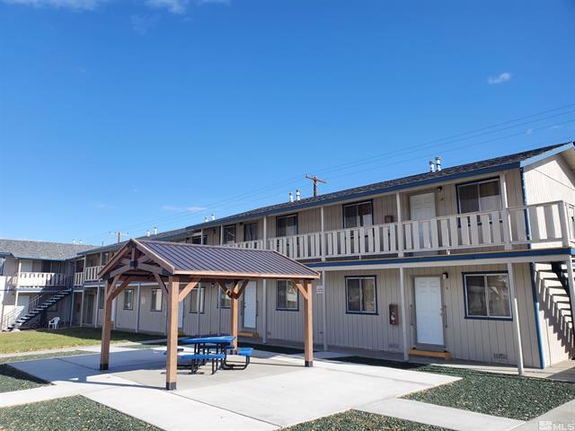
This Property Is For Sale
NEARBY LISTINGS FOR SALE OR LEASE
-
-
View all Hawthorne listings for sale on LoopNet.com
Property Detail
420 H St
001-233-11
Hawthorne
Multifamilydwelling
HAWTHORNE-LTS 32-38
AO
Mineral
32021C1015C
Nevada
2024
38
2025
0.36 AC
970700
Carson City/Nevada Area
7,824 SF
Other Market Areas
DEMOGRAPHICS near 420 H St
1 Mile
3 Mile
5 Mile
2024 Total Population
2,731
3,030
3,157
2029 Population
2,648
2,948
3,073
Pop Growth 2024-2029
(3.04%)
(2.71%)
(2.66%)
Average Age
45
45
44
2024 Total Households
1,259
1,389
1,447
HH Growth 2024-2029
(3.10%)
(2.81%)
(2.76%)
Median Household Inc
$51,839
$51,272
$50,470
Avg Household Size
2.10
2.10
2.10
2024 Avg HH Vehicles
2.00
2.00
2.00
Median Home Value
$164,055
$159,533
$153,319
Median Year Built
1969
1970
1970
Nearby Places
- Restaurants
- Banks
- Shops
- Fitness
- Groceries
Nearby Properties
Address
Land Use
TOTAL SIZE
Lot Size
Zoning
Address
Land Use
TOTAL SIZE
Lot Size
Zoning
68,761 SF
52.99 AC
P;PUBLIC
Address
Land Use
TOTAL SIZE
Lot Size
Zoning
74,176 SF
0.83 AC
C1;COMMERC
Address
Land Use
TOTAL SIZE
Lot Size
Zoning
42,236 SF
2.30 AC
C1;COMMERC
Address
Land Use
TOTAL SIZE
Lot Size
Zoning
27,300 SF
13 AC
C1;COMMERC
Address
Land Use
TOTAL SIZE
Lot Size
Zoning
7,200 SF
7.14 AC
C1
Address
Land Use
TOTAL SIZE
Lot Size
Zoning
10,411 SF
3.40 AC
P;PUBLIC
Address
Land Use
TOTAL SIZE
Lot Size
Zoning
43.70 AC
M1;INDUSTR
Address
Land Use
TOTAL SIZE
Lot Size
Zoning
13,098 SF
5.93 AC
C1;COMMERC
Address
Land Use
TOTAL SIZE
Lot Size
Zoning
25,488 SF
18.18 AC
P;PUBLIC
Address
Land Use
TOTAL SIZE
Lot Size
Zoning
10,956 SF
2.58 AC
P;PUBLIC
Address
Land Use
TOTAL SIZE
Lot Size
Zoning
20,225 SF
0.68 AC
C1;COMMERC
Address
Land Use
TOTAL SIZE
Lot Size
Zoning
4,790 SF
2 AC
C1;COMMERC
Address
Land Use
TOTAL SIZE
Lot Size
Zoning
16,836 SF
1.84 AC
R3;MULTI F
Address
Land Use
TOTAL SIZE
Lot Size
Zoning
3,275 SF
2 AC
M3;OPEN US
Address
Land Use
TOTAL SIZE
Lot Size
Zoning
26,564 SF
2.40 AC
C1;COMMERC
Address
Land Use
TOTAL SIZE
Lot Size
Zoning
5,742 SF
0.62 AC
C1;COMMERC
Address
Land Use
TOTAL SIZE
Lot Size
Zoning
7,200 SF
Address
Land Use
TOTAL SIZE
Lot Size
Zoning
8,000 SF
0.92 AC
C1;COMMERC
Address
Land Use
TOTAL SIZE
Lot Size
Zoning
9,100 SF
0.97 AC
C1;COMMERC
Address
Land Use
TOTAL SIZE
Lot Size
Zoning
14,492 SF
1.15 AC
C1;COMMERC
Address
Land Use
TOTAL SIZE
Lot Size
Zoning
13,602 SF
0.92 AC
C1;COMMERC
Address
Land Use
TOTAL SIZE
Lot Size
Zoning
2,304 SF
1.17 AC
C1;COMMERC
Address
Land Use
TOTAL SIZE
Lot Size
Zoning
9,120 SF
0.76 AC
P;PUBLIC
Address
Land Use
TOTAL SIZE
Lot Size
Zoning
11,609 SF
2.50 AC
P;PUBLIC
Address
Land Use
TOTAL SIZE
Lot Size
Zoning
13,600 SF
0.88 AC
C1;COMMERC
Address
Land Use
TOTAL SIZE
Lot Size
Zoning
4,484 SF
0.10 AC
R2T;LTD MU
Address
Land Use
TOTAL SIZE
Lot Size
Zoning
3,280 SF
0.31 AC
C1;COMMERC
Address
Land Use
TOTAL SIZE
Lot Size
Zoning
6.01 AC
M1;INDUSTR
Address
Land Use
TOTAL SIZE
Lot Size
Zoning
7,344 SF
0.69 AC
C1;COMMERC
The World's #1 Commercial Real Estate Marketplace
Connect with us
© 2025 CoStar Group
The information above has been obtained from sources believed reliable. While we do not doubt its accuracy we have not verified it and make no guarantee, warranty or representation about it. It is your responsibility to independently confirm its accuracy and completeness. Any projections, opinions, assumptions, or estimates used are for example only and do not represent the current or future performance of the property. The value of this transaction to you depends on tax and other factors which should be evaluated by your tax, financial, and legal advisors. You and your advisors should conduct a careful, independent investigation of the property to determine to your satisfaction the suitability of the property for your needs.