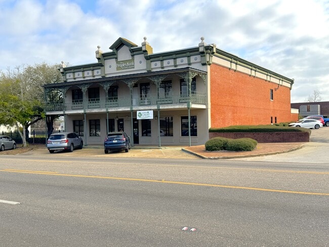
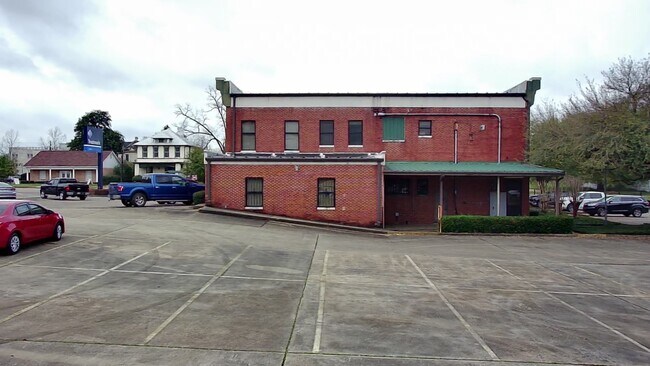
Property Record
420 Broad St, Selma, AL 36701

Save to a Folder
{{folder.Name}}
{{folder.ListingIds.length}} Properties
{{folder.ListingIds.length}} Property
Create a New Folder
Property Detail
420 Broad St
11-07-36-1-004-034.0000
LOT 26 & W 20' LOT 27 & S 5' VACATED ALLEY BLK 61 BROAD ST. DB-1027 PG-543 DB-1333 PG-243
Officebuilding
DALLAS
C
Alabama
B and X Area of moderate flood hazard, usually the area between the limits of the 100-year and 500-year floods.
26-27
2025
0.26 AC
2025
Alabama South Area
956500
Other Market Areas
14,734 SF
Selma, AL
NEARBY LISTINGS FOR SALE OR LEASE
DEMOGRAPHICS near 420 Broad St
1 mile
3 mile
5 mile
2025 Total Population
6,272
17,869
22,162
2030 Population
6,135
16,877
20,942
Pop Growth 2025-2030
(2.18%)
(5.55%)
(5.50%)
Average Age
39
40
41
2025 Total Households
2,617
7,432
9,196
HH Growth 2025-2030
(2.10%)
(5.69%)
(5.64%)
Median Household Inc
$23,958
$32,960
$35,058
Avg Household Size
2.30
2.30
2.30
2025 Avg HH Vehicles
1.00
2.00
2.00
Median Home Value
$78,550
$91,433
$96,363
Median Year Built
1955
1967
1969
Nearby Places
Map Layers
Map Styles
 Street
 Aerial
Layers
 Traffic
 Biking
Places
Listings with unknown addresses are not visible on the map
- Restaurants
- Banks
- Shops
- Fitness
- Groceries
SALE & LEASE HISTORY
LISTING DATE
SALE/LEASE

Mar 27, 2025
For Sale
Nearby Properties
Address
Land Use
TOTAL SIZE
Lot Size
Zoning
Address
Land Use
TOTAL SIZE
Lot Size
Zoning
230,750 SF
7.34 AC
C
Address
Land Use
TOTAL SIZE
Lot Size
Zoning
180,393 SF
19.10 AC
C
Address
Land Use
TOTAL SIZE
Lot Size
Zoning
87,391 SF
2.66 AC
Address
Land Use
TOTAL SIZE
Lot Size
Zoning
27,185 SF
1.96 AC
C
Address
Land Use
TOTAL SIZE
Lot Size
Zoning
42,285 SF
0.53 AC
C
Address
Land Use
TOTAL SIZE
Lot Size
Zoning
53,225 SF
7.51 AC
C
Address
Land Use
TOTAL SIZE
Lot Size
Zoning
112,856 SF
11.02 AC
I
Address
Land Use
TOTAL SIZE
Lot Size
Zoning
44,944 SF
0.17 AC
N
Address
Land Use
TOTAL SIZE
Lot Size
Zoning
18,260 SF
10 AC
N
Address
Land Use
TOTAL SIZE
Lot Size
Zoning
145,338 SF
6.82 AC
C
Address
Land Use
TOTAL SIZE
Lot Size
Zoning
156,542 SF
46 AC
C
Address
Land Use
TOTAL SIZE
Lot Size
Zoning
4,814 SF
6 AC
M
Address
Land Use
TOTAL SIZE
Lot Size
Zoning
6,650 SF
10 AC
O
Address
Land Use
TOTAL SIZE
Lot Size
Zoning
64,854 SF
2.31 AC
O
Address
Land Use
TOTAL SIZE
Lot Size
Zoning
6,374 SF
3.18 AC
S
Address
Land Use
TOTAL SIZE
Lot Size
Zoning
62,913 SF
0.92 AC
Address
Land Use
TOTAL SIZE
Lot Size
Zoning
7,788 SF
8 AC
M
Address
Land Use
TOTAL SIZE
Lot Size
Zoning
1,494 SF
12 AC
S
Address
Land Use
TOTAL SIZE
Lot Size
Zoning
7,606 SF
4.80 AC
C
Address
Land Use
TOTAL SIZE
Lot Size
Zoning
53,100 SF
7.15 AC
O
Address
Land Use
TOTAL SIZE
Lot Size
Zoning
100,410 SF
22.11 AC
I
Address
Land Use
TOTAL SIZE
Lot Size
Zoning
34,495 SF
5.68 AC
N
Address
Land Use
TOTAL SIZE
Lot Size
Zoning
8,034 SF
22 AC
S
Address
Land Use
TOTAL SIZE
Lot Size
Zoning
49,699 SF
3.70 AC
C
Address
Land Use
TOTAL SIZE
Lot Size
Zoning
2,941 SF
22.98 AC
C
Address
Land Use
TOTAL SIZE
Lot Size
Zoning
2,608 SF
10 AC
M
Address
Land Use
TOTAL SIZE
Lot Size
Zoning
12,051 SF
1.04 AC
C
Address
Land Use
TOTAL SIZE
Lot Size
Zoning
50,267 SF
5.77 AC
C
Address
Land Use
TOTAL SIZE
Lot Size
Zoning
24,657 SF
4.23 AC
N
Address
Land Use
TOTAL SIZE
Lot Size
Zoning
18,248 SF
16.02 AC
N
The World's #1 Commercial Real Estate Marketplace
Connect with us
© 2026 CoStar Group
The information above has been obtained from sources believed reliable. While we do not doubt its accuracy we have not verified it and make no guarantee, warranty or representation about it. It is your responsibility to independently confirm its accuracy and completeness. Any projections, opinions, assumptions, or estimates used are for example only and do not represent the current or future performance of the property. The value of this transaction to you depends on tax and other factors which should be evaluated by your tax, financial, and legal advisors. You and your advisors should conduct a careful, independent investigation of the property to determine to your satisfaction the suitability of the property for your needs.