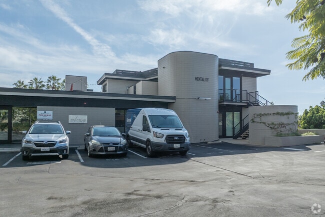
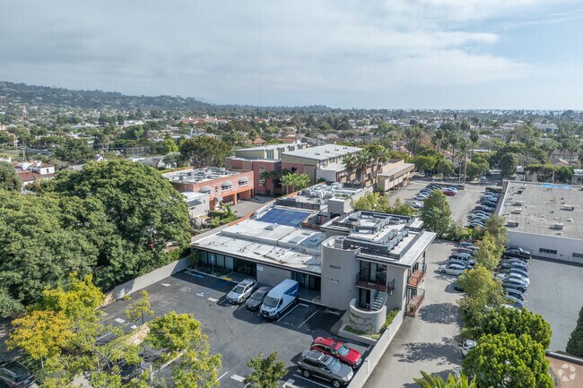
Property Record
420 E Carrillo St, Santa Barbara, CA 93101


Property Detail
420 E Carrillo St
Santa Maria-Santa Barbara, CA
TRACT 11464 LOT 23
029-302-028
Santa Barbara
Officebuilding
California
B and X Area of moderate flood hazard, usually the area between the limits of the 100-year and 500-year floods.
23
2024
0.45 AC
2025
N Santa Barbara/Goleta
000900
Santa Barbara/Sta Maria/Goleta
NEARBY LISTINGS FOR SALE OR LEASE
DEMOGRAPHICS near 420 E Carrillo St
1 mile
3 mile
5 mile
2025 Total Population
21,860
86,956
109,315
2030 Population
21,615
86,558
109,231
Pop Growth 2025-2030
(1.12%)
(0.46%)
(0.08%)
Average Age
40
41
43
2025 Total Households
9,732
34,318
43,398
HH Growth 2025-2030
(1.17%)
(0.50%)
(0.12%)
Median Household Inc
$81,768
$101,658
$105,692
Avg Household Size
2.10
2.40
2.40
2025 Avg HH Vehicles
1.00
2.00
2.00
Median Home Value
$1,121,509
$1,120,556
$1,115,451
Median Year Built
1958
1962
1964
Nearby Places
Map Layers
Map Styles
 Street
 Aerial
Layers
 Traffic
 Biking
Places
Listings with unknown addresses are not visible on the map
- Restaurants
- Banks
- Shops
- Fitness
- Groceries
PUBLIC TRANSPORTATION
COMMUTER RAIL
Drive
Walk
Distance
4 min
1.2 mi
AIRPORT
Santa Barbara Municipal
Drive
Walk
Distance
Santa Barbara Municipal
30 min
12.4 mi
SALE & LEASE HISTORY
LISTING DATE
SALE/LEASE

May 14, 2018
For Lease
Feb 27, 2023
For Lease
Apr 08, 2021
For Lease
Apr 03, 2025
For Lease
Nearby Properties
Address
Land Use
TOTAL SIZE
Lot Size
Zoning
Address
Land Use
TOTAL SIZE
Lot Size
Zoning
710 SF
9.92 AC
SP8
Address
Land Use
TOTAL SIZE
Lot Size
Zoning
21.85 AC
HRC1SP
Address
Land Use
TOTAL SIZE
Lot Size
Zoning
16.87 AC
E3SD2
Address
Land Use
TOTAL SIZE
Lot Size
Zoning
0.39 AC
C2
Address
Land Use
TOTAL SIZE
Lot Size
Zoning
7.06 AC
R240R
Address
Land Use
TOTAL SIZE
Lot Size
Zoning
Address
Land Use
TOTAL SIZE
Lot Size
Zoning
1.16 AC
Address
Land Use
TOTAL SIZE
Lot Size
Zoning
77.82 AC
A2SD3
Address
Land Use
TOTAL SIZE
Lot Size
Zoning
183,552 SF
50.14 AC
SP5
Address
Land Use
TOTAL SIZE
Lot Size
Zoning
1.12 AC
HRC1SD
Address
Land Use
TOTAL SIZE
Lot Size
Zoning
0.75 AC
HRC2SD
Address
Land Use
TOTAL SIZE
Lot Size
Zoning
0.37 AC
C2
Address
Land Use
TOTAL SIZE
Lot Size
Zoning
1.35 AC
CM
Address
Land Use
TOTAL SIZE
Lot Size
Zoning
6.59 AC
R2SD3
Address
Land Use
TOTAL SIZE
Lot Size
Zoning
0.57 AC
CM
Address
Land Use
TOTAL SIZE
Lot Size
Zoning
4.32 AC
CP
Address
Land Use
TOTAL SIZE
Lot Size
Zoning
0.99 AC
Address
Land Use
TOTAL SIZE
Lot Size
Zoning
9.21 AC
R2
Address
Land Use
TOTAL SIZE
Lot Size
Zoning
1.32 AC
Address
Land Use
TOTAL SIZE
Lot Size
Zoning
7.44 AC
OM1SD3
Address
Land Use
TOTAL SIZE
Lot Size
Zoning
1 AC
HRC1SD
Address
Land Use
TOTAL SIZE
Lot Size
Zoning
1.65 AC
HRC2SD
Address
Land Use
TOTAL SIZE
Lot Size
Zoning
0.48 AC
HRC2SD
Address
Land Use
TOTAL SIZE
Lot Size
Zoning
2.62 AC
C2
Address
Land Use
TOTAL SIZE
Lot Size
Zoning
1.29 AC
HRC1SD
Address
Land Use
TOTAL SIZE
Lot Size
Zoning
11.37 AC
E1
Address
Land Use
TOTAL SIZE
Lot Size
Zoning
27,346 SF
8.72 AC
SP7
Address
Land Use
TOTAL SIZE
Lot Size
Zoning
1,525 SF
2.40 AC
SP8
Address
Land Use
TOTAL SIZE
Lot Size
Zoning
0.30 AC
C2
Address
Land Use
TOTAL SIZE
Lot Size
Zoning
1 AC
C2
The World's #1 Commercial Real Estate Marketplace
Connect with us
© 2026 CoStar Group
The information above has been obtained from sources believed reliable. While we do not doubt its accuracy we have not verified it and make no guarantee, warranty or representation about it. It is your responsibility to independently confirm its accuracy and completeness. Any projections, opinions, assumptions, or estimates used are for example only and do not represent the current or future performance of the property. The value of this transaction to you depends on tax and other factors which should be evaluated by your tax, financial, and legal advisors. You and your advisors should conduct a careful, independent investigation of the property to determine to your satisfaction the suitability of the property for your needs.