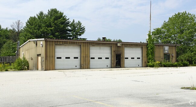
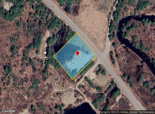
Property Record
420 Hancock Rd, Peterborough, NH 03458

NEARBY LISTINGS FOR SALE OR LEASE
Property Detail
420 Hancock Rd
PTBR-000011R-000043-000200
Hillsborough
Autorepair
New Hampshire
A
200
33011C0287D
3.05 AC
2024
Hillsborough
2024
Boston
023002
Manchester-Nashua, NH
DEMOGRAPHICS near 420 Hancock Rd
1 Mile
3 Mile
5 Mile
2024 Total Population
401
3,660
10,000
2029 Population
413
3,743
10,228
Pop Growth 2024-2029
+ 2.99%
+ 2.27%
+ 2.28%
Average Age
44
45
46
2024 Total Households
156
1,495
4,210
HH Growth 2024-2029
+ 3.21%
+ 2.27%
+ 2.30%
Median Household Inc
$95,088
$97,499
$98,512
Avg Household Size
2.50
2.40
2.30
2024 Avg HH Vehicles
2.00
2.00
2.00
Median Home Value
$311,842
$352,388
$372,549
Median Year Built
1982
1974
1969
Nearby Places
Map Layers
Map Styles
 Street
 Aerial
- Restaurants
- Banks
- Shops
- Fitness
- Groceries
PUBLIC TRANSPORTATION
AIRPORT
Manchester Boston Regional
DRIVE
WALK
Distance
Manchester Boston Regional
70 min
39.9 mi
Freight Ports
Port of Boston
DRIVE
WALK
Distance
Port of Boston
118 min
74.6 mi
Nearby Properties
Address
Land Use
TOTAL SIZE
Lot Size
Zoning
Address
Land Use
TOTAL SIZE
Lot Size
Zoning
30 AC
FAMILY
Address
Land Use
TOTAL SIZE
Lot Size
Zoning
88.50 AC
R
Address
Land Use
TOTAL SIZE
Lot Size
Zoning
24.24 AC
R
Address
Land Use
TOTAL SIZE
Lot Size
Zoning
369.99 AC
R
Address
Land Use
TOTAL SIZE
Lot Size
Zoning
331.37 AC
FAMILY
Address
Land Use
TOTAL SIZE
Lot Size
Zoning
8.31 AC
GEN.RE
Address
Land Use
TOTAL SIZE
Lot Size
Zoning
7.50 AC
GEN.RE
Address
Land Use
TOTAL SIZE
Lot Size
Zoning
Address
Land Use
TOTAL SIZE
Lot Size
Zoning
12.71 AC
R
Address
Land Use
TOTAL SIZE
Lot Size
Zoning
10 AC
INDUST
Address
Land Use
TOTAL SIZE
Lot Size
Zoning
23.06 AC
INDUST
Address
Land Use
TOTAL SIZE
Lot Size
Zoning
19.84 AC
R
Address
Land Use
TOTAL SIZE
Lot Size
Zoning
Address
Land Use
TOTAL SIZE
Lot Size
Zoning
14.27 AC
GEN.RE
Address
Land Use
TOTAL SIZE
Lot Size
Zoning
73.43 AC
R
Address
Land Use
TOTAL SIZE
Lot Size
Zoning
16.17 AC
R
Address
Land Use
TOTAL SIZE
Lot Size
Zoning
5.02 AC
COMMER
Address
Land Use
TOTAL SIZE
Lot Size
Zoning
35 AC
R
Address
Land Use
TOTAL SIZE
Lot Size
Zoning
3,879 SF
37 AC
RURALR
Address
Land Use
TOTAL SIZE
Lot Size
Zoning
138.16 AC
R
Address
Land Use
TOTAL SIZE
Lot Size
Zoning
108.42 AC
RURALR
Address
Land Use
TOTAL SIZE
Lot Size
Zoning
2.10 AC
COMMER
Address
Land Use
TOTAL SIZE
Lot Size
Zoning
19.09 AC
R
Address
Land Use
TOTAL SIZE
Lot Size
Zoning
Address
Land Use
TOTAL SIZE
Lot Size
Zoning
Address
Land Use
TOTAL SIZE
Lot Size
Zoning
Address
Land Use
TOTAL SIZE
Lot Size
Zoning
0.82 AC
COMMER
Address
Land Use
TOTAL SIZE
Lot Size
Zoning
3.52 AC
R
Address
Land Use
TOTAL SIZE
Lot Size
Zoning
61.75 AC
R
Address
Land Use
TOTAL SIZE
Lot Size
Zoning
85.33 AC
R
The World's #1 Commercial Real Estate Marketplace
Connect with us
© 2025 CoStar Group
The information above has been obtained from sources believed reliable. While we do not doubt its accuracy we have not verified it and make no guarantee, warranty or representation about it. It is your responsibility to independently confirm its accuracy and completeness. Any projections, opinions, assumptions, or estimates used are for example only and do not represent the current or future performance of the property. The value of this transaction to you depends on tax and other factors which should be evaluated by your tax, financial, and legal advisors. You and your advisors should conduct a careful, independent investigation of the property to determine to your satisfaction the suitability of the property for your needs.