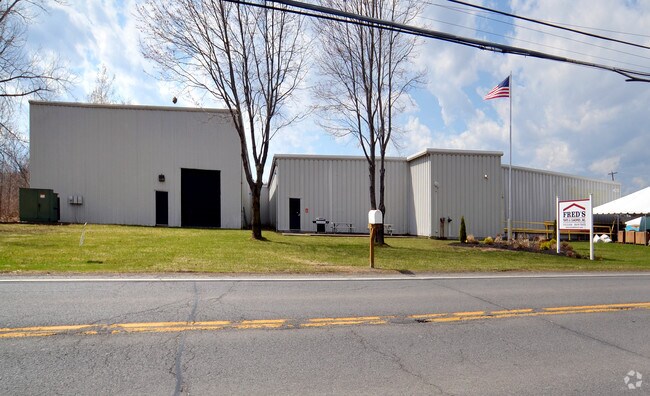
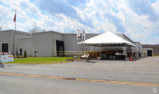
Property Record
420 Hudson River Rd, Waterford, NY 12188

NEARBY LISTINGS FOR SALE OR LEASE
Property Detail
420 Hudson River Rd
Albany-Schenectady-Troy, NY
WAREHOUSE/LAND
413800-286-000-0001-054-000-0000
Saratoga
Warehouse
New York
2025
54.000
2024
5.25 AC
062404
Saratoga County
79,555 SF
Albany/Schenectady/Troy
DEMOGRAPHICS near 420 Hudson River Rd
1 Mile
3 Mile
5 Mile
2024 Total Population
255
13,877
59,463
2029 Population
255
13,926
58,964
Pop Growth 2024-2029
0.00%
+ 0.35%
(0.84%)
Average Age
48
43
42
2024 Total Households
111
5,895
26,616
HH Growth 2024-2029
0.00%
+ 0.39%
(0.95%)
Median Household Inc
$98,437
$74,352
$69,648
Avg Household Size
2.30
2.30
2.20
2024 Avg HH Vehicles
2.00
2.00
2.00
Median Home Value
$304,545
$232,316
$220,789
Median Year Built
1989
1964
1966
Nearby Places
Map Layers
Map Styles
 Street
 Aerial
- Restaurants
- Banks
- Shops
- Fitness
- Groceries
PUBLIC TRANSPORTATION
AIRPORT
Albany International
DRIVE
WALK
Distance
Albany International
21 min
12.3 mi
Freight Ports
Albany, NY Port
DRIVE
WALK
Distance
Albany, NY Port
28 min
15.8 mi
Nearby Properties
Address
Land Use
TOTAL SIZE
Lot Size
Zoning
Address
Land Use
TOTAL SIZE
Lot Size
Zoning
173.09 AC
Address
Land Use
TOTAL SIZE
Lot Size
Zoning
5,000 SF
48.44 AC
CR
Address
Land Use
TOTAL SIZE
Lot Size
Zoning
39.06 AC
Address
Land Use
TOTAL SIZE
Lot Size
Zoning
Address
Land Use
TOTAL SIZE
Lot Size
Zoning
193,144 SF
41.18 AC
Address
Land Use
TOTAL SIZE
Lot Size
Zoning
4,680 SF
26.74 AC
Address
Land Use
TOTAL SIZE
Lot Size
Zoning
723,643 SF
27.56 AC
Address
Land Use
TOTAL SIZE
Lot Size
Zoning
5,500 SF
15.31 AC
MU2
Address
Land Use
TOTAL SIZE
Lot Size
Zoning
3,844 SF
3.18 AC
Address
Land Use
TOTAL SIZE
Lot Size
Zoning
Address
Land Use
TOTAL SIZE
Lot Size
Zoning
52 AC
CR
Address
Land Use
TOTAL SIZE
Lot Size
Zoning
95,800 SF
23.50 AC
Address
Land Use
TOTAL SIZE
Lot Size
Zoning
75,872 SF
8.26 AC
SF
Address
Land Use
TOTAL SIZE
Lot Size
Zoning
15,562 SF
1.91 AC
WMU
Address
Land Use
TOTAL SIZE
Lot Size
Zoning
88.48 AC
Address
Land Use
TOTAL SIZE
Lot Size
Zoning
30,600 SF
258.51 AC
Address
Land Use
TOTAL SIZE
Lot Size
Zoning
30,390 SF
1.20 AC
03 - MULTI
Address
Land Use
TOTAL SIZE
Lot Size
Zoning
114,539 SF
11.64 AC
Address
Land Use
TOTAL SIZE
Lot Size
Zoning
44,500 SF
6.71 AC
WMU
Address
Land Use
TOTAL SIZE
Lot Size
Zoning
49.19 AC
Address
Land Use
TOTAL SIZE
Lot Size
Zoning
60,794 SF
7.87 AC
Address
Land Use
TOTAL SIZE
Lot Size
Zoning
16,712 SF
11.64 AC
Address
Land Use
TOTAL SIZE
Lot Size
Zoning
1.46 AC
Address
Land Use
TOTAL SIZE
Lot Size
Zoning
3,408 SF
4 AC
Address
Land Use
TOTAL SIZE
Lot Size
Zoning
23,688 SF
25.75 AC
06 - INDUS
Address
Land Use
TOTAL SIZE
Lot Size
Zoning
0.01 AC
Address
Land Use
TOTAL SIZE
Lot Size
Zoning
10,044 SF
5.02 AC
06 - INDUS
Address
Land Use
TOTAL SIZE
Lot Size
Zoning
121,620 SF
7.19 AC
06 - INDUS
Address
Land Use
TOTAL SIZE
Lot Size
Zoning
16,281 SF
1.84 AC
WMU
Address
Land Use
TOTAL SIZE
Lot Size
Zoning
9,100 SF
5.89 AC
02 - SINGL
The World's #1 Commercial Real Estate Marketplace
Connect with us
© 2025 CoStar Group
The information above has been obtained from sources believed reliable. While we do not doubt its accuracy we have not verified it and make no guarantee, warranty or representation about it. It is your responsibility to independently confirm its accuracy and completeness. Any projections, opinions, assumptions, or estimates used are for example only and do not represent the current or future performance of the property. The value of this transaction to you depends on tax and other factors which should be evaluated by your tax, financial, and legal advisors. You and your advisors should conduct a careful, independent investigation of the property to determine to your satisfaction the suitability of the property for your needs.