Property Record
420 Mcnulty St, Blythewood, SC 29016


NEARBY LISTINGS FOR SALE OR LEASE
-
-
View all Blythewood listings for sale on LoopNet.com
Property Detail
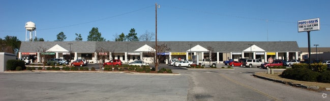
420 Mcnulty St
15200-02-30
Longcreek Plantation
Commercialnec
178.1X217.4X60X65.1X20X365.4X 283.5 #SU
X
Richland
45079C0128L
South Carolina
2025
1.41 AC
2024
Northeast Columbia
010106
Columbia
20,482 SF
Columbia, SC
DEMOGRAPHICS near 420 Mcnulty St
1 Mile
3 Mile
5 Mile
2024 Total Population
1,529
11,613
32,000
2029 Population
1,576
11,954
32,788
Pop Growth 2024-2029
+ 3.07%
+ 2.94%
+ 2.46%
Average Age
37
39
38
2024 Total Households
533
4,134
11,437
HH Growth 2024-2029
+ 3.00%
+ 2.98%
+ 2.56%
Median Household Inc
$73,499
$85,242
$85,985
Avg Household Size
2.90
2.80
2.80
2024 Avg HH Vehicles
2.00
2.00
2.00
Median Home Value
$287,152
$285,842
$266,606
Median Year Built
2001
2007
2006
Nearby Places
Map Layers
Map Styles
 Street
 Aerial
- Restaurants
- Banks
- Shops
- Fitness
- Groceries
PUBLIC TRANSPORTATION
AIRPORT
Columbia Metro
DRIVE
WALK
Distance
Columbia Metro
44 min
28.5 mi
Freight Ports
North Charleston Terminal
DRIVE
WALK
Distance
North Charleston Terminal
143 min
125.6 mi
SALE & LEASE HISTORY
LISTING DATE
SALE/LEASE

Apr 15, 2018
For Sale
Nearby Properties
Address
Land Use
TOTAL SIZE
Lot Size
Zoning
Address
Land Use
TOTAL SIZE
Lot Size
Zoning
18,000 SF
52.20 AC
GC
Address
Land Use
TOTAL SIZE
Lot Size
Zoning
33.32 AC
M-1
Address
Land Use
TOTAL SIZE
Lot Size
Zoning
287.63 AC
D-1
Address
Land Use
TOTAL SIZE
Lot Size
Zoning
65,665 SF
7.03 AC
GC
Address
Land Use
TOTAL SIZE
Lot Size
Zoning
184,000 SF
9.67 AC
M-1
Address
Land Use
TOTAL SIZE
Lot Size
Zoning
52,568 SF
1.93 AC
D-1
Address
Land Use
TOTAL SIZE
Lot Size
Zoning
2,740 SF
5 AC
D-1
Address
Land Use
TOTAL SIZE
Lot Size
Zoning
41,025 SF
6.80 AC
C-3
Address
Land Use
TOTAL SIZE
Lot Size
Zoning
112,228 SF
20.34 AC
M-1
Address
Land Use
TOTAL SIZE
Lot Size
Zoning
43,988 SF
1.64 AC
D-1
Address
Land Use
TOTAL SIZE
Lot Size
Zoning
112,975 SF
21.20 AC
M-1
Address
Land Use
TOTAL SIZE
Lot Size
Zoning
20,760 SF
12.68 AC
GC
Address
Land Use
TOTAL SIZE
Lot Size
Zoning
23,492 SF
84.58 AC
GC
Address
Land Use
TOTAL SIZE
Lot Size
Zoning
51,493 SF
2.08 AC
C-3
Address
Land Use
TOTAL SIZE
Lot Size
Zoning
2,124 SF
231.26 AC
PD
Address
Land Use
TOTAL SIZE
Lot Size
Zoning
56,511 SF
8.16 AC
D-1
Address
Land Use
TOTAL SIZE
Lot Size
Zoning
10.40 AC
RU
Address
Land Use
TOTAL SIZE
Lot Size
Zoning
89.20 AC
M-1
Address
Land Use
TOTAL SIZE
Lot Size
Zoning
23.52 AC
M-1
Address
Land Use
TOTAL SIZE
Lot Size
Zoning
59,248 SF
3.90 AC
TC
Address
Land Use
TOTAL SIZE
Lot Size
Zoning
20,000 SF
2.03 AC
M-1
Address
Land Use
TOTAL SIZE
Lot Size
Zoning
3,454 SF
1.52 AC
C-3
Address
Land Use
TOTAL SIZE
Lot Size
Zoning
3.31 AC
OI
Address
Land Use
TOTAL SIZE
Lot Size
Zoning
12,727 SF
14.64 AC
RU
Address
Land Use
TOTAL SIZE
Lot Size
Zoning
70.10 AC
M-1
Address
Land Use
TOTAL SIZE
Lot Size
Zoning
51,004 SF
12 AC
M-1
Address
Land Use
TOTAL SIZE
Lot Size
Zoning
13,340 SF
1.97 AC
PD
Address
Land Use
TOTAL SIZE
Lot Size
Zoning
56,674 SF
3.01 AC
C-3
Address
Land Use
TOTAL SIZE
Lot Size
Zoning
11,106 SF
5 AC
RU
Address
Land Use
TOTAL SIZE
Lot Size
Zoning
43,745 SF
5.30 AC
M-1
The World's #1 Commercial Real Estate Marketplace
Connect with us
© 2026 CoStar Group
The information above has been obtained from sources believed reliable. While we do not doubt its accuracy we have not verified it and make no guarantee, warranty or representation about it. It is your responsibility to independently confirm its accuracy and completeness. Any projections, opinions, assumptions, or estimates used are for example only and do not represent the current or future performance of the property. The value of this transaction to you depends on tax and other factors which should be evaluated by your tax, financial, and legal advisors. You and your advisors should conduct a careful, independent investigation of the property to determine to your satisfaction the suitability of the property for your needs.