Property Record
420 N Industrial Rd, El Dorado, KS 67042
NEARBY LISTINGS FOR SALE OR LEASE
-
-
View all El Dorado listings for sale on LoopNet.com
Property Detail
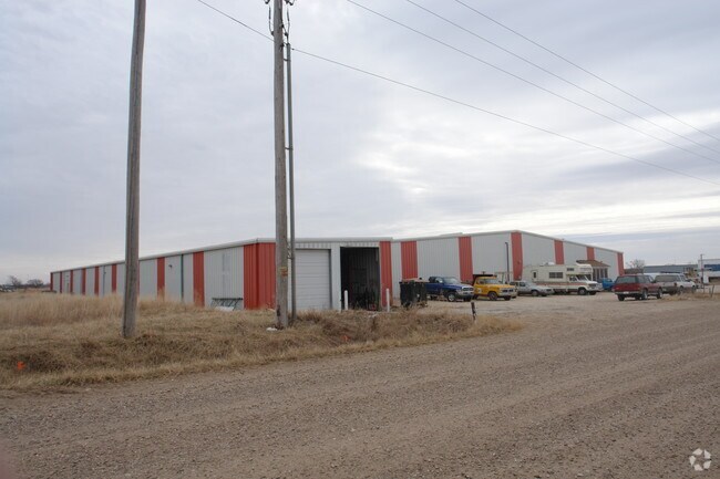
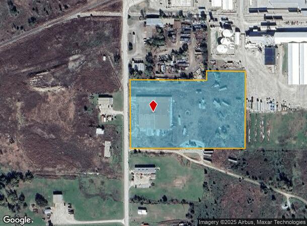
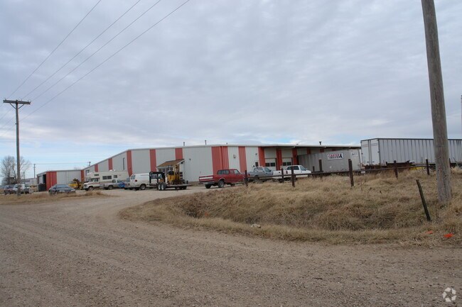
420 N Industrial Rd
213-05-0-00-00-010-00-0
S05, T26, R05E, ACRES 7.1, PT NW4 BEG 734.33S NW/C NE4 NW4 E500 N56.03 E230.94 S476.03 W731.16 N420 TO POB LESS ROW
Warehouse
Butler
X
Kansas
20015C0358E
7.10 AC
2024
Outlying Butler County
2025
Wichita
020205
Wichita, KS
37,200 SF
DEMOGRAPHICS near 420 N Industrial Rd
1 Mile
3 Mile
5 Mile
2024 Total Population
399
7,528
15,419
2029 Population
411
7,779
15,943
Pop Growth 2024-2029
+ 3.01%
+ 3.33%
+ 3.40%
Average Age
36
38
40
2024 Total Households
133
3,068
6,155
HH Growth 2024-2029
+ 3.76%
+ 3.42%
+ 3.51%
Median Household Inc
$56,666
$50,721
$54,943
Avg Household Size
2.30
2.30
2.30
2024 Avg HH Vehicles
2.00
2.00
2.00
Median Home Value
$114,444
$78,893
$110,708
Median Year Built
1979
1957
1962
Nearby Places
Map Layers
Map Styles
 Street
 Aerial
- Restaurants
- Banks
- Shops
- Fitness
- Groceries
Nearby Properties
Address
Land Use
TOTAL SIZE
Lot Size
Zoning
Address
Land Use
TOTAL SIZE
Lot Size
Zoning
349.90 AC
Address
Land Use
TOTAL SIZE
Lot Size
Zoning
31,128 SF
77.10 AC
Address
Land Use
TOTAL SIZE
Lot Size
Zoning
9,000 SF
34.50 AC
Address
Land Use
TOTAL SIZE
Lot Size
Zoning
231,043 SF
7.80 AC
Address
Land Use
TOTAL SIZE
Lot Size
Zoning
70,579 SF
16.90 AC
Address
Land Use
TOTAL SIZE
Lot Size
Zoning
28,160 SF
268.60 AC
Address
Land Use
TOTAL SIZE
Lot Size
Zoning
75,973 SF
8.10 AC
Address
Land Use
TOTAL SIZE
Lot Size
Zoning
12,918 SF
33.60 AC
Address
Land Use
TOTAL SIZE
Lot Size
Zoning
57,849 SF
8.70 AC
Address
Land Use
TOTAL SIZE
Lot Size
Zoning
19,869 SF
36.10 AC
Address
Land Use
TOTAL SIZE
Lot Size
Zoning
28,484 SF
Address
Land Use
TOTAL SIZE
Lot Size
Zoning
193,828 SF
34.40 AC
Address
Land Use
TOTAL SIZE
Lot Size
Zoning
20,896 SF
2.70 AC
Address
Land Use
TOTAL SIZE
Lot Size
Zoning
24,590 SF
2 AC
Address
Land Use
TOTAL SIZE
Lot Size
Zoning
1.70 AC
C1
Address
Land Use
TOTAL SIZE
Lot Size
Zoning
Address
Land Use
TOTAL SIZE
Lot Size
Zoning
1.80 AC
Address
Land Use
TOTAL SIZE
Lot Size
Zoning
62,580 SF
24.20 AC
Address
Land Use
TOTAL SIZE
Lot Size
Zoning
16,380 SF
116.60 AC
Address
Land Use
TOTAL SIZE
Lot Size
Zoning
11,444 SF
2.20 AC
Address
Land Use
TOTAL SIZE
Lot Size
Zoning
204,004 SF
16.80 AC
Address
Land Use
TOTAL SIZE
Lot Size
Zoning
4,208 SF
1.30 AC
R1
Address
Land Use
TOTAL SIZE
Lot Size
Zoning
2,250 SF
2.80 AC
C1
Address
Land Use
TOTAL SIZE
Lot Size
Zoning
180,000 SF
11.90 AC
Address
Land Use
TOTAL SIZE
Lot Size
Zoning
12,087 SF
2.40 AC
I1
Address
Land Use
TOTAL SIZE
Lot Size
Zoning
11,286 SF
11 AC
Address
Land Use
TOTAL SIZE
Lot Size
Zoning
2,160 SF
81.50 AC
Address
Land Use
TOTAL SIZE
Lot Size
Zoning
15,561 SF
1.90 AC
Address
Land Use
TOTAL SIZE
Lot Size
Zoning
40,304 SF
4.20 AC
Address
Land Use
TOTAL SIZE
Lot Size
Zoning
69,410 SF
15.60 AC
The World's #1 Commercial Real Estate Marketplace
Connect with us
© 2025 CoStar Group
The information above has been obtained from sources believed reliable. While we do not doubt its accuracy we have not verified it and make no guarantee, warranty or representation about it. It is your responsibility to independently confirm its accuracy and completeness. Any projections, opinions, assumptions, or estimates used are for example only and do not represent the current or future performance of the property. The value of this transaction to you depends on tax and other factors which should be evaluated by your tax, financial, and legal advisors. You and your advisors should conduct a careful, independent investigation of the property to determine to your satisfaction the suitability of the property for your needs.