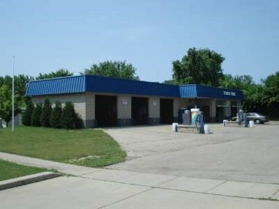
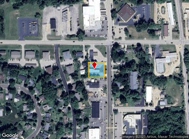
Property Record
420 N Main St, Deforest, WI 53532


NEARBY LISTINGS FOR SALE OR LEASE
Property Detail
420 N Main St
Madison, WI
SEC 18-9-10 PRT NE1/4 NE1/4 COM INTERS W LN MAIN ST & S LN CTH V TH S 267 FT W 1 47 FT N 267 FT E 147 FT TO POB EXC N 127 FT THF
0910-181-8490-5
Dane
Commercialnec
Wisconsin
X
90
55021C0565F
0.47 AC
2024
Outlying Dane East
2024
Milwaukee/Madison
012004
DEMOGRAPHICS near 420 N Main St
1 Mile
3 Mile
5 Mile
2024 Total Population
6,656
17,008
22,480
2029 Population
6,828
17,736
23,417
Pop Growth 2024-2029
+ 2.58%
+ 4.28%
+ 4.17%
Average Age
39
39
39
2024 Total Households
2,559
6,446
8,448
HH Growth 2024-2029
+ 2.58%
+ 4.36%
+ 4.24%
Median Household Inc
$88,024
$93,637
$99,000
Avg Household Size
2.60
2.60
2.60
2024 Avg HH Vehicles
2.00
2.00
2.00
Median Home Value
$289,127
$321,568
$338,058
Median Year Built
1985
1990
1990
Nearby Places
Map Layers
Map Styles
 Street
 Aerial
- Restaurants
- Banks
- Shops
- Fitness
- Groceries
PUBLIC TRANSPORTATION
AIRPORT
Dane County Regional/Truax Field
DRIVE
WALK
Distance
Dane County Regional/Truax Field
17 min
11.4 mi
Freight Ports
Port Milwaukee
DRIVE
WALK
Distance
Port Milwaukee
99 min
85.5 mi
SALE & LEASE HISTORY
LISTING DATE
SALE/LEASE

Nov 30, 2016
For Sale
Dec 29, 2016
For Sale
Nearby Properties
Address
Land Use
TOTAL SIZE
Lot Size
Zoning
Address
Land Use
TOTAL SIZE
Lot Size
Zoning
26.50 AC
Address
Land Use
TOTAL SIZE
Lot Size
Zoning
3.77 AC
Address
Land Use
TOTAL SIZE
Lot Size
Zoning
15.91 AC
Address
Land Use
TOTAL SIZE
Lot Size
Zoning
21.88 AC
Address
Land Use
TOTAL SIZE
Lot Size
Zoning
13.40 AC
Address
Land Use
TOTAL SIZE
Lot Size
Zoning
19.56 AC
Address
Land Use
TOTAL SIZE
Lot Size
Zoning
3.60 AC
Address
Land Use
TOTAL SIZE
Lot Size
Zoning
2.59 AC
Address
Land Use
TOTAL SIZE
Lot Size
Zoning
11.62 AC
Address
Land Use
TOTAL SIZE
Lot Size
Zoning
9.10 AC
Address
Land Use
TOTAL SIZE
Lot Size
Zoning
14.75 AC
Address
Land Use
TOTAL SIZE
Lot Size
Zoning
3.72 AC
R-4
Address
Land Use
TOTAL SIZE
Lot Size
Zoning
38.60 AC
Address
Land Use
TOTAL SIZE
Lot Size
Zoning
11.08 AC
Address
Land Use
TOTAL SIZE
Lot Size
Zoning
1.87 AC
R-4
Address
Land Use
TOTAL SIZE
Lot Size
Zoning
6.31 AC
Address
Land Use
TOTAL SIZE
Lot Size
Zoning
17.93 AC
ETZ
Address
Land Use
TOTAL SIZE
Lot Size
Zoning
1.50 AC
Address
Land Use
TOTAL SIZE
Lot Size
Zoning
1.21 AC
Address
Land Use
TOTAL SIZE
Lot Size
Zoning
4.91 AC
Address
Land Use
TOTAL SIZE
Lot Size
Zoning
Address
Land Use
TOTAL SIZE
Lot Size
Zoning
0.60 AC
Address
Land Use
TOTAL SIZE
Lot Size
Zoning
6.15 AC
Address
Land Use
TOTAL SIZE
Lot Size
Zoning
4.10 AC
Address
Land Use
TOTAL SIZE
Lot Size
Zoning
6.56 AC
Address
Land Use
TOTAL SIZE
Lot Size
Zoning
Address
Land Use
TOTAL SIZE
Lot Size
Zoning
9.38 AC
Address
Land Use
TOTAL SIZE
Lot Size
Zoning
1.32 AC
The World's #1 Commercial Real Estate Marketplace
Connect with us
© 2025 CoStar Group
The information above has been obtained from sources believed reliable. While we do not doubt its accuracy we have not verified it and make no guarantee, warranty or representation about it. It is your responsibility to independently confirm its accuracy and completeness. Any projections, opinions, assumptions, or estimates used are for example only and do not represent the current or future performance of the property. The value of this transaction to you depends on tax and other factors which should be evaluated by your tax, financial, and legal advisors. You and your advisors should conduct a careful, independent investigation of the property to determine to your satisfaction the suitability of the property for your needs.