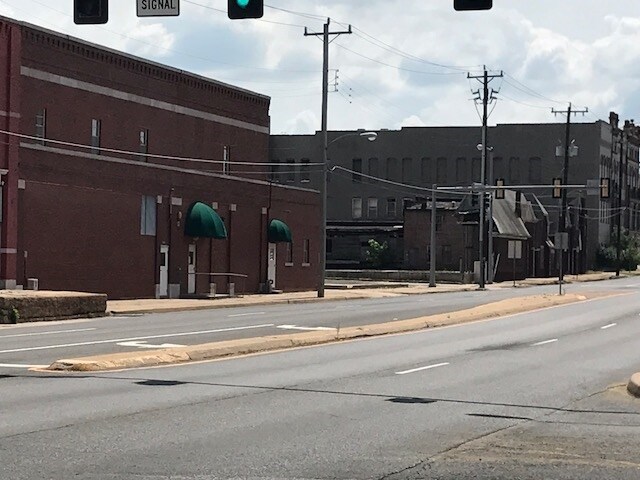
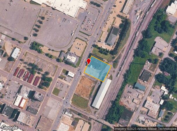
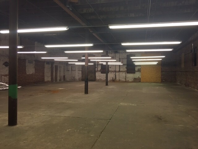
Property Record
420 N Main St, Muskogee, OK 74401
NEARBY LISTINGS FOR SALE OR LEASE
Property Detail
420 N Main St
Muskogee, OK
Muskogee Ot
4610-26-015-006-1-015-09
MUSKOGEE OT LOT 6 LESS N61 MEASURED ON W X N62 MEASURED ON E & ALL LOT 7 LESS S20 BLOCK 15
Distributionwarehouseregional
Muskogee
X
Oklahoma
40145C0500H
6,7
2025
0.93 AC
2025
Muskogee County
000400
Tulsa
4,056 SF
DEMOGRAPHICS near 420 N Main St
1 mile
3 mile
5 mile
2024 Total Population
6,883
35,556
42,110
2029 Population
7,105
35,961
42,487
Pop Growth 2024-2029
+ 3.23%
+ 1.14%
+ 0.90%
Average Age
37
38
39
2024 Total Households
2,718
14,388
17,052
HH Growth 2024-2029
+ 3.35%
+ 1.11%
+ 0.87%
Median Household Inc
$31,358
$39,924
$41,503
Avg Household Size
2.30
2.30
2.30
2024 Avg HH Vehicles
2.00
2.00
2.00
Median Home Value
$59,340
$93,529
$106,094
Median Year Built
1954
1970
1972
Nearby Places
Map Layers
Map Styles
 Street
 Aerial
Transit
 Traffic
 Biking
Places
Listings with unknown addresses are not visible on the map
- Restaurants
- Banks
- Shops
- Fitness
- Groceries
SALE & LEASE HISTORY
LISTING DATE
SALE/LEASE

Sep 23, 2016
For Sale
Aug 31, 2017
For Sale
Nearby Properties
Address
Land Use
TOTAL SIZE
Lot Size
Zoning
Address
Land Use
TOTAL SIZE
Lot Size
Zoning
49,127 SF
17.48 AC
Address
Land Use
TOTAL SIZE
Lot Size
Zoning
1,760 SF
21.64 AC
Address
Land Use
TOTAL SIZE
Lot Size
Zoning
35,682 SF
1.75 AC
F
Address
Land Use
TOTAL SIZE
Lot Size
Zoning
59,306 SF
0.74 AC
MI
Address
Land Use
TOTAL SIZE
Lot Size
Zoning
69,776 SF
20.13 AC
Address
Land Use
TOTAL SIZE
Lot Size
Zoning
52,964 SF
4.86 AC
MI
Address
Land Use
TOTAL SIZE
Lot Size
Zoning
43,002 SF
1.09 AC
MI
Address
Land Use
TOTAL SIZE
Lot Size
Zoning
19,548 SF
3.77 AC
B
Address
Land Use
TOTAL SIZE
Lot Size
Zoning
20,962 SF
1.51 AC
MI
Address
Land Use
TOTAL SIZE
Lot Size
Zoning
8,796 SF
17.35 AC
Address
Land Use
TOTAL SIZE
Lot Size
Zoning
25,200 SF
12.06 AC
Address
Land Use
TOTAL SIZE
Lot Size
Zoning
14,488 SF
0.11 AC
E1
Address
Land Use
TOTAL SIZE
Lot Size
Zoning
43,440 SF
2.79 AC
E1
Address
Land Use
TOTAL SIZE
Lot Size
Zoning
5,040 SF
8.40 AC
Address
Land Use
TOTAL SIZE
Lot Size
Zoning
51,616 SF
2.98 AC
PP
Address
Land Use
TOTAL SIZE
Lot Size
Zoning
11,071 SF
1.86 AC
Address
Land Use
TOTAL SIZE
Lot Size
Zoning
6,000 SF
1.39 AC
Address
Land Use
TOTAL SIZE
Lot Size
Zoning
34,000 SF
1.20 AC
Address
Land Use
TOTAL SIZE
Lot Size
Zoning
30,594 SF
0.85 AC
E1
Address
Land Use
TOTAL SIZE
Lot Size
Zoning
11,200 SF
8.72 AC
Address
Land Use
TOTAL SIZE
Lot Size
Zoning
12,552 SF
0.88 AC
B
Address
Land Use
TOTAL SIZE
Lot Size
Zoning
4,752 SF
2.58 AC
B
Address
Land Use
TOTAL SIZE
Lot Size
Zoning
2,080 SF
0.46 AC
MI
Address
Land Use
TOTAL SIZE
Lot Size
Zoning
20.13 AC
A
Address
Land Use
TOTAL SIZE
Lot Size
Zoning
1,500 SF
10 AC
Address
Land Use
TOTAL SIZE
Lot Size
Zoning
34,070 SF
2.33 AC
PP
Address
Land Use
TOTAL SIZE
Lot Size
Zoning
7,649 SF
2.22 AC
Address
Land Use
TOTAL SIZE
Lot Size
Zoning
56,000 SF
5.60 AC
Address
Land Use
TOTAL SIZE
Lot Size
Zoning
The World's #1 Commercial Real Estate Marketplace
Connect with us
© 2026 CoStar Group
The information above has been obtained from sources believed reliable. While we do not doubt its accuracy we have not verified it and make no guarantee, warranty or representation about it. It is your responsibility to independently confirm its accuracy and completeness. Any projections, opinions, assumptions, or estimates used are for example only and do not represent the current or future performance of the property. The value of this transaction to you depends on tax and other factors which should be evaluated by your tax, financial, and legal advisors. You and your advisors should conduct a careful, independent investigation of the property to determine to your satisfaction the suitability of the property for your needs.