Property Record
420 N Wilbur Ave, Walla Walla, WA 99362


NEARBY LISTINGS FOR SALE OR LEASE
Property Detail
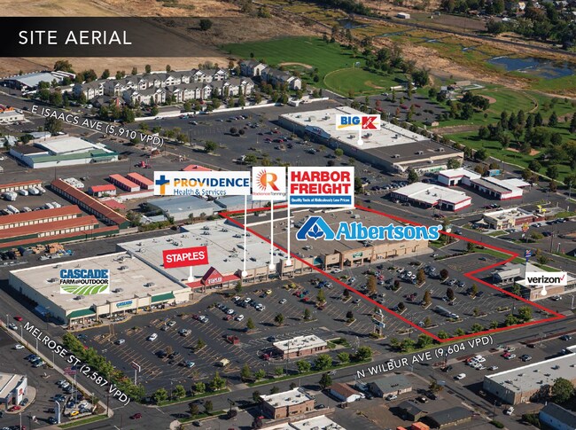
420 N Wilbur Ave
Walla Walla, WA
Eastgate Market Place
360722220081
22-7-36 PARCEL 2 OF BINDING SITE PLAN SURVEY TAX 60A, 60, 56A, 51A,51 & PTN TAX 109; ALSO BLK 14 ALL WITHIN NW1/4NW1/4
Storebuilding
Walla Walla
2025
Washington
2025
81
920801
4.70 AC
67,297 SF
Other Market Areas
DEMOGRAPHICS near 420 N Wilbur Ave
1 Mile
3 Mile
5 Mile
2024 Total Population
9,611
33,826
49,535
2029 Population
9,772
34,354
50,251
Pop Growth 2024-2029
+ 1.68%
+ 1.56%
+ 1.45%
Average Age
39
40
41
2024 Total Households
3,851
12,714
18,735
HH Growth 2024-2029
+ 1.48%
+ 1.58%
+ 1.52%
Median Household Inc
$68,892
$61,102
$62,390
Avg Household Size
2.50
2.40
2.40
2024 Avg HH Vehicles
2.00
2.00
2.00
Median Home Value
$284,558
$326,921
$340,884
Median Year Built
1969
1962
1972
Nearby Places
Map Layers
Map Styles
 Street
 Aerial
- Restaurants
- Banks
- Shops
- Fitness
- Groceries
PUBLIC TRANSPORTATION
AIRPORT
Walla Walla Regional
DRIVE
WALK
Distance
Walla Walla Regional
4 min
1.9 mi
Freight Ports
Port of Tacoma
DRIVE
WALK
Distance
Port of Tacoma
331 min
286.8 mi
SALE & LEASE HISTORY
LISTING DATE
SALE/LEASE

Jun 26, 2020
For Sale
Nearby Properties
Address
Land Use
TOTAL SIZE
Lot Size
Zoning
Address
Land Use
TOTAL SIZE
Lot Size
Zoning
118,836 SF
9.43 AC
Address
Land Use
TOTAL SIZE
Lot Size
Zoning
3.14 AC
Address
Land Use
TOTAL SIZE
Lot Size
Zoning
105,506 SF
68.44 AC
Address
Land Use
TOTAL SIZE
Lot Size
Zoning
128,578 SF
10.56 AC
Address
Land Use
TOTAL SIZE
Lot Size
Zoning
200,872 SF
42.83 AC
Address
Land Use
TOTAL SIZE
Lot Size
Zoning
251,468 SF
6.17 AC
Address
Land Use
TOTAL SIZE
Lot Size
Zoning
65,472 SF
1.79 AC
Address
Land Use
TOTAL SIZE
Lot Size
Zoning
64,021 SF
2 AC
Address
Land Use
TOTAL SIZE
Lot Size
Zoning
128,366 SF
14.78 AC
Address
Land Use
TOTAL SIZE
Lot Size
Zoning
29,764 SF
51.24 AC
Address
Land Use
TOTAL SIZE
Lot Size
Zoning
50,745 SF
4.10 AC
Address
Land Use
TOTAL SIZE
Lot Size
Zoning
114,582 SF
5.47 AC
Address
Land Use
TOTAL SIZE
Lot Size
Zoning
92,070 SF
3.82 AC
Address
Land Use
TOTAL SIZE
Lot Size
Zoning
171,813 SF
20.38 AC
Address
Land Use
TOTAL SIZE
Lot Size
Zoning
73,529 SF
4.32 AC
Address
Land Use
TOTAL SIZE
Lot Size
Zoning
76,064 SF
10.67 AC
Address
Land Use
TOTAL SIZE
Lot Size
Zoning
223,200 SF
11.21 AC
Address
Land Use
TOTAL SIZE
Lot Size
Zoning
52,166 SF
9.55 AC
Address
Land Use
TOTAL SIZE
Lot Size
Zoning
52,062 SF
9 AC
Address
Land Use
TOTAL SIZE
Lot Size
Zoning
91,972 SF
3.47 AC
Address
Land Use
TOTAL SIZE
Lot Size
Zoning
105,028 SF
4.50 AC
Address
Land Use
TOTAL SIZE
Lot Size
Zoning
34,792 SF
3.21 AC
Address
Land Use
TOTAL SIZE
Lot Size
Zoning
105,989 SF
0.69 AC
Address
Land Use
TOTAL SIZE
Lot Size
Zoning
52,572 SF
13.13 AC
Address
Land Use
TOTAL SIZE
Lot Size
Zoning
13,564 SF
303.40 AC
Address
Land Use
TOTAL SIZE
Lot Size
Zoning
59,987 SF
3.21 AC
Address
Land Use
TOTAL SIZE
Lot Size
Zoning
59,775 SF
7.15 AC
Address
Land Use
TOTAL SIZE
Lot Size
Zoning
65,624 SF
7.20 AC
Address
Land Use
TOTAL SIZE
Lot Size
Zoning
61,027 SF
3.46 AC
Address
Land Use
TOTAL SIZE
Lot Size
Zoning
69,096 SF
1.81 AC
The World's #1 Commercial Real Estate Marketplace
Connect with us
© 2026 CoStar Group
The information above has been obtained from sources believed reliable. While we do not doubt its accuracy we have not verified it and make no guarantee, warranty or representation about it. It is your responsibility to independently confirm its accuracy and completeness. Any projections, opinions, assumptions, or estimates used are for example only and do not represent the current or future performance of the property. The value of this transaction to you depends on tax and other factors which should be evaluated by your tax, financial, and legal advisors. You and your advisors should conduct a careful, independent investigation of the property to determine to your satisfaction the suitability of the property for your needs.