Property Record
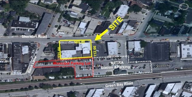
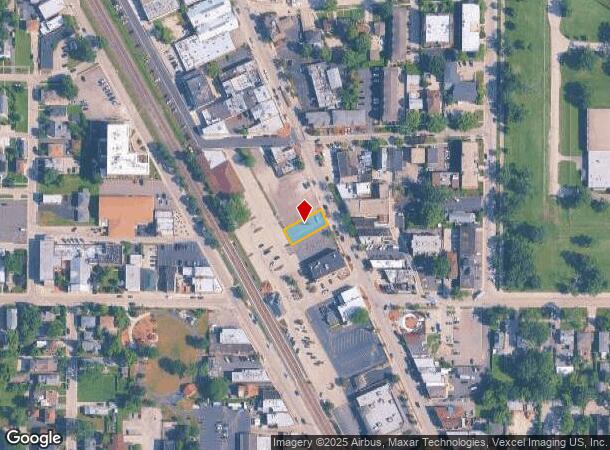
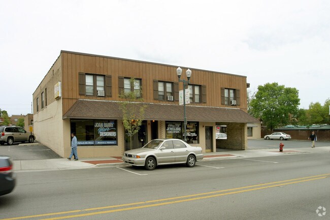
420 Sheridan Rd, Highwood, IL 60040
NEARBY LISTINGS FOR SALE OR LEASE
Property Detail
420 Sheridan Rd
Chicago-Naperville-Elgin, IL-IN-WI
Highwood
16-15-208-041
HIGHWOOD S 50 FT N 169FT (EX STRIP FOR RY) LOT 62
Taxexempt
Lake
X
Illinois
17097C0283L
62
0
0.14 AC
2024
Central North
865200
Chicago
20,072 SF
DEMOGRAPHICS near 420 Sheridan Rd
1 Mile
3 Mile
5 Mile
2024 Total Population
10,063
41,784
90,879
2029 Population
9,817
41,323
89,813
Pop Growth 2024-2029
(2.44%)
(1.10%)
(1.17%)
Average Age
40
42
43
2024 Total Households
3,640
15,315
33,417
HH Growth 2024-2029
(2.55%)
(1.10%)
(1.28%)
Median Household Inc
$102,637
$153,058
$155,511
Avg Household Size
2.70
2.60
2.60
2024 Avg HH Vehicles
2.00
2.00
2.00
Median Home Value
$482,602
$636,790
$653,015
Median Year Built
1956
1965
1969
Nearby Places
Map Layers
Map Styles
 Street
 Aerial
- Restaurants
- Banks
- Shops
- Fitness
- Groceries
PUBLIC TRANSPORTATION
COMMUTER RAIL
Highwood Station (Union Pacific North Line - Northeast Illinois Regional Commuter Railroad (Metra))
DRIVE
WALK
Distance
Highwood Station (Union Pacific North Line - Northeast Illinois Regional Commuter Railroad (Metra))
1 min
5 min
0.3 mi
Fort Sheridan Station (Union Pacific North Line - Northeast Illinois Regional Commuter Railroad (Metra))
DRIVE
WALK
Distance
Fort Sheridan Station (Union Pacific North Line - Northeast Illinois Regional Commuter Railroad (Metra))
3 min
1.3 mi
AIRPORT
Chicago O'Hare International
DRIVE
WALK
Distance
Chicago O'Hare International
33 min
22.9 mi
Chicago Midway International
DRIVE
WALK
Distance
Chicago Midway International
51 min
33.8 mi
Freight Ports
Port Milwaukee
DRIVE
WALK
Distance
Port Milwaukee
73 min
60.3 mi
Nearby Properties
Address
Land Use
TOTAL SIZE
Lot Size
Zoning
Address
Land Use
TOTAL SIZE
Lot Size
Zoning
244,300 SF
2.46 AC
Address
Land Use
TOTAL SIZE
Lot Size
Zoning
806,580 SF
7.64 AC
Address
Land Use
TOTAL SIZE
Lot Size
Zoning
0.57 AC
Address
Land Use
TOTAL SIZE
Lot Size
Zoning
78.54 AC
Address
Land Use
TOTAL SIZE
Lot Size
Zoning
129,900 SF
0.76 AC
Address
Land Use
TOTAL SIZE
Lot Size
Zoning
191,025 SF
15.66 AC
Address
Land Use
TOTAL SIZE
Lot Size
Zoning
510,213 SF
1.27 AC
Address
Land Use
TOTAL SIZE
Lot Size
Zoning
74,599 SF
9.16 AC
Address
Land Use
TOTAL SIZE
Lot Size
Zoning
79,073 SF
8.70 AC
Address
Land Use
TOTAL SIZE
Lot Size
Zoning
3,896 SF
4.36 AC
Address
Land Use
TOTAL SIZE
Lot Size
Zoning
0.46 AC
Address
Land Use
TOTAL SIZE
Lot Size
Zoning
131,219 SF
2.58 AC
Address
Land Use
TOTAL SIZE
Lot Size
Zoning
250,096 SF
2.16 AC
Address
Land Use
TOTAL SIZE
Lot Size
Zoning
Address
Land Use
TOTAL SIZE
Lot Size
Zoning
127,191 SF
76.51 AC
Address
Land Use
TOTAL SIZE
Lot Size
Zoning
313,794 SF
6.91 AC
Address
Land Use
TOTAL SIZE
Lot Size
Zoning
74,190 SF
1.79 AC
Address
Land Use
TOTAL SIZE
Lot Size
Zoning
40,820 SF
5.79 AC
Address
Land Use
TOTAL SIZE
Lot Size
Zoning
94,920 SF
2.25 AC
Address
Land Use
TOTAL SIZE
Lot Size
Zoning
75,528 SF
7.83 AC
Address
Land Use
TOTAL SIZE
Lot Size
Zoning
136,929 SF
15.35 AC
Address
Land Use
TOTAL SIZE
Lot Size
Zoning
49,226 SF
0.65 AC
Address
Land Use
TOTAL SIZE
Lot Size
Zoning
71,948 SF
13.39 AC
Address
Land Use
TOTAL SIZE
Lot Size
Zoning
110,355 SF
10.12 AC
Address
Land Use
TOTAL SIZE
Lot Size
Zoning
67,900 SF
0.96 AC
Address
Land Use
TOTAL SIZE
Lot Size
Zoning
205,616 SF
2.79 AC
Address
Land Use
TOTAL SIZE
Lot Size
Zoning
290,040 SF
2.91 AC
Address
Land Use
TOTAL SIZE
Lot Size
Zoning
0.31 AC
Address
Land Use
TOTAL SIZE
Lot Size
Zoning
110,358 SF
10.04 AC
Address
Land Use
TOTAL SIZE
Lot Size
Zoning
110,379 SF
8.94 AC
The World's #1 Commercial Real Estate Marketplace
Connect with us
© 2025 CoStar Group
The information above has been obtained from sources believed reliable. While we do not doubt its accuracy we have not verified it and make no guarantee, warranty or representation about it. It is your responsibility to independently confirm its accuracy and completeness. Any projections, opinions, assumptions, or estimates used are for example only and do not represent the current or future performance of the property. The value of this transaction to you depends on tax and other factors which should be evaluated by your tax, financial, and legal advisors. You and your advisors should conduct a careful, independent investigation of the property to determine to your satisfaction the suitability of the property for your needs.