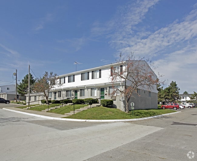
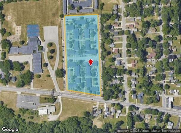
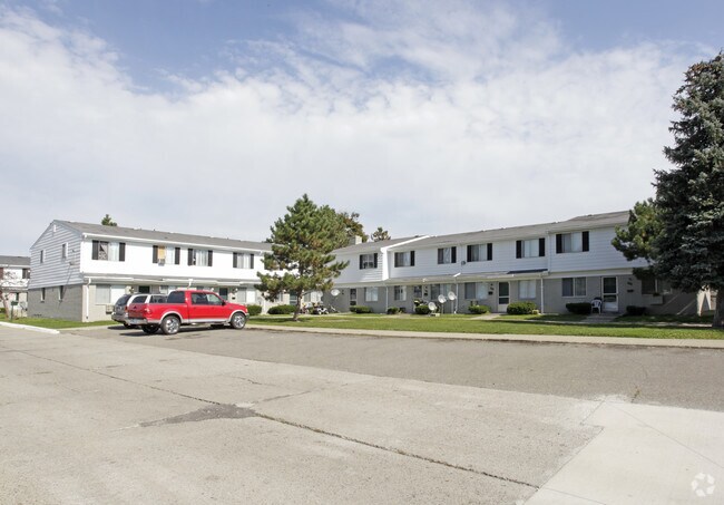
Property Record
420 W Kennett Rd, Pontiac, MI 48340

NEARBY LISTINGS FOR SALE OR LEASE
Property Detail
420 W Kennett Rd
14-18-402-006
Sect 18 T3n R10e
Multifamilydwelling
T3N, R10E, SEC 18 PART OF SE 1/4 BEG AT PT DIST S 85-11-50 W 1312.10 FT & S 01-54-10 E 1099.65 FT FROM E 1/4 COR, TH S 01-54-10 E 837.52 FT, TH N 80-40-20 W 342.36 FT, TH N 83-44-20 W 55.82 FT, TH N 02-02-10 W 762.45 FT, TH N 88-04-00 E 393.15 FT TO
X
Oakland
26125C0362F
Michigan
2024
5.64 AC
2024
Pontiac
141400
Detroit
117,399 SF
Detroit-Warren-Dearborn, MI
DEMOGRAPHICS near 420 W Kennett Rd
1 Mile
3 Mile
5 Mile
2024 Total Population
9,884
71,789
154,622
2029 Population
9,793
71,558
154,062
Pop Growth 2024-2029
(0.92%)
(0.32%)
(0.36%)
Average Age
36
39
40
2024 Total Households
3,926
29,308
65,132
HH Growth 2024-2029
(0.99%)
(0.37%)
(0.44%)
Median Household Inc
$34,609
$48,074
$55,831
Avg Household Size
2.40
2.30
2.30
2024 Avg HH Vehicles
1.00
2.00
2.00
Median Home Value
$61,191
$137,830
$183,610
Median Year Built
1959
1962
1968
Nearby Places
Map Layers
Map Styles
 Street
 Aerial
- Restaurants
- Banks
- Shops
- Fitness
- Groceries
PUBLIC TRANSPORTATION
COMMUTER RAIL
Pontiac Amtrak Station (Wolverine - Amtrak)
DRIVE
WALK
Distance
Pontiac Amtrak Station (Wolverine - Amtrak)
8 min
3.0 mi
Freight Ports
Port of Toledo
DRIVE
WALK
Distance
Port of Toledo
112 min
84.7 mi
Nearby Properties
Address
Land Use
TOTAL SIZE
Lot Size
Zoning
Address
Land Use
TOTAL SIZE
Lot Size
Zoning
1,421,000 SF
170.30 AC
B2
Address
Land Use
TOTAL SIZE
Lot Size
Zoning
420,858 SF
65.07 AC
Address
Land Use
TOTAL SIZE
Lot Size
Zoning
1,771,589 SF
96.73 AC
Address
Land Use
TOTAL SIZE
Lot Size
Zoning
426,034 SF
24.99 AC
AI
Address
Land Use
TOTAL SIZE
Lot Size
Zoning
101,320 SF
28.20 AC
Address
Land Use
TOTAL SIZE
Lot Size
Zoning
79,263 SF
22.27 AC
Address
Land Use
TOTAL SIZE
Lot Size
Zoning
174,265 SF
13.50 AC
TR
Address
Land Use
TOTAL SIZE
Lot Size
Zoning
110,521 SF
3.23 AC
B2
Address
Land Use
TOTAL SIZE
Lot Size
Zoning
65,432 SF
16.57 AC
Address
Land Use
TOTAL SIZE
Lot Size
Zoning
1,870,974 SF
61.73 AC
Address
Land Use
TOTAL SIZE
Lot Size
Zoning
71,140 SF
Address
Land Use
TOTAL SIZE
Lot Size
Zoning
150,090 SF
11.74 AC
I1
Address
Land Use
TOTAL SIZE
Lot Size
Zoning
1,786 SF
78 AC
PUD
Address
Land Use
TOTAL SIZE
Lot Size
Zoning
143,701 SF
9.85 AC
AI
Address
Land Use
TOTAL SIZE
Lot Size
Zoning
Address
Land Use
TOTAL SIZE
Lot Size
Zoning
131,214 SF
10.75 AC
AI
Address
Land Use
TOTAL SIZE
Lot Size
Zoning
146,736 SF
14.81 AC
AI
Address
Land Use
TOTAL SIZE
Lot Size
Zoning
235,395 SF
Address
Land Use
TOTAL SIZE
Lot Size
Zoning
88,110 SF
3.15 AC
AI
Address
Land Use
TOTAL SIZE
Lot Size
Zoning
1,332,530 SF
95.81 AC
Address
Land Use
TOTAL SIZE
Lot Size
Zoning
235,395 SF
37.19 AC
Address
Land Use
TOTAL SIZE
Lot Size
Zoning
235,395 SF
34.42 AC
Address
Land Use
TOTAL SIZE
Lot Size
Zoning
211,861 SF
2.69 AC
BI
Address
Land Use
TOTAL SIZE
Lot Size
Zoning
68,107 SF
Address
Land Use
TOTAL SIZE
Lot Size
Zoning
123,938 SF
11.23 AC
I1
Address
Land Use
TOTAL SIZE
Lot Size
Zoning
129,630 SF
9.51 AC
Address
Land Use
TOTAL SIZE
Lot Size
Zoning
80,600 SF
51.48 AC
Address
Land Use
TOTAL SIZE
Lot Size
Zoning
1,771,589 SF
Address
Land Use
TOTAL SIZE
Lot Size
Zoning
210,350 SF
32.38 AC
BI
Address
Land Use
TOTAL SIZE
Lot Size
Zoning
118,777 SF
3.21 AC
B2
The World's #1 Commercial Real Estate Marketplace
Connect with us
© 2025 CoStar Group
The information above has been obtained from sources believed reliable. While we do not doubt its accuracy we have not verified it and make no guarantee, warranty or representation about it. It is your responsibility to independently confirm its accuracy and completeness. Any projections, opinions, assumptions, or estimates used are for example only and do not represent the current or future performance of the property. The value of this transaction to you depends on tax and other factors which should be evaluated by your tax, financial, and legal advisors. You and your advisors should conduct a careful, independent investigation of the property to determine to your satisfaction the suitability of the property for your needs.