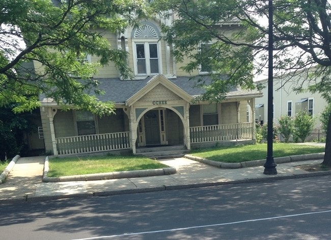
Property Record
420 Washington St, Dorchester Center, MA 02124


Current Lease Availabilities
NEARBY LISTINGS FOR SALE OR LEASE
Property Detail
420 Washington St
Medicalbuilding
Suffolk
X
Massachusetts
25025C0087G
0.22 AC
2025
Roxbury/Dorchester
2025
Boston
092000
Boston-Cambridge-Newton, MA-NH
3,812 SF
DORC-000000-000017-002419
DEMOGRAPHICS near 420 Washington St
1 Mile
3 Mile
5 Mile
2024 Total Population
60,601
306,236
714,735
2029 Population
56,767
290,917
688,666
Pop Growth 2024-2029
(6.33%)
(5.00%)
(3.65%)
Average Age
37
38
38
2024 Total Households
20,453
117,057
295,323
HH Growth 2024-2029
(6.99%)
(5.49%)
(3.92%)
Median Household Inc
$54,134
$70,425
$89,191
Avg Household Size
2.80
2.40
2.20
2024 Avg HH Vehicles
1.00
1.00
1.00
Median Home Value
$607,689
$663,768
$755,561
Median Year Built
1947
1948
1950
Nearby Places
Map Layers
Map Styles
 Street
 Aerial
- Restaurants
- Banks
- Shops
- Fitness
- Groceries
PUBLIC TRANSPORTATION
TRANSIT/SUBWAY
Fields Corner Station (Red Line - Massachusetts Bay Transportation Authority Subway (The T))
DRIVE
WALK
Distance
Fields Corner Station (Red Line - Massachusetts Bay Transportation Authority Subway (The T))
2 min
11 min
0.6 mi
Shawmut Station (Red Line - Massachusetts Bay Transportation Authority Subway (The T))
DRIVE
WALK
Distance
Shawmut Station (Red Line - Massachusetts Bay Transportation Authority Subway (The T))
2 min
12 min
0.7 mi
COMMUTER RAIL
Talbot Avenue (Fairmount Line - MBTA, Franklin/Foxboro Line - MBTA)
DRIVE
WALK
Distance
Talbot Avenue (Fairmount Line - MBTA, Franklin/Foxboro Line - MBTA)
2 min
12 min
0.6 mi
Four Corners/Geneva (Fairmount Line - MBTA, Franklin/Foxboro Line - MBTA)
DRIVE
WALK
Distance
Four Corners/Geneva (Fairmount Line - MBTA, Franklin/Foxboro Line - MBTA)
2 min
14 min
0.8 mi
AIRPORT
General Edward Lawrence Logan International
DRIVE
WALK
Distance
General Edward Lawrence Logan International
16 min
7.7 mi
Freight Ports
Port of Boston
DRIVE
WALK
Distance
Port of Boston
12 min
5.4 mi
Nearby Properties
Address
Land Use
TOTAL SIZE
Lot Size
Zoning
Address
Land Use
TOTAL SIZE
Lot Size
Zoning
909,764 SF
25.13 AC
E
Address
Land Use
TOTAL SIZE
Lot Size
Zoning
377,634 SF
4.86 AC
E
Address
Land Use
TOTAL SIZE
Lot Size
Zoning
254,208 SF
3.83 AC
E
Address
Land Use
TOTAL SIZE
Lot Size
Zoning
262,120 SF
0.62 AC
C
Address
Land Use
TOTAL SIZE
Lot Size
Zoning
259,990 SF
2.84 AC
E
Address
Land Use
TOTAL SIZE
Lot Size
Zoning
547,851 SF
8.14 AC
E
Address
Land Use
TOTAL SIZE
Lot Size
Zoning
305,455 SF
0.54 AC
RC
Address
Land Use
TOTAL SIZE
Lot Size
Zoning
303,055 SF
2.15 AC
RC
Address
Land Use
TOTAL SIZE
Lot Size
Zoning
468,308 SF
0.78 AC
E
Address
Land Use
TOTAL SIZE
Lot Size
Zoning
249,135 SF
1.99 AC
RC
Address
Land Use
TOTAL SIZE
Lot Size
Zoning
522,465 SF
5.34 AC
E
Address
Land Use
TOTAL SIZE
Lot Size
Zoning
76,658 SF
0.38 AC
E
Address
Land Use
TOTAL SIZE
Lot Size
Zoning
251,272 SF
3.77 AC
BUSC
Address
Land Use
TOTAL SIZE
Lot Size
Zoning
254,856 SF
4.05 AC
BUSC
Address
Land Use
TOTAL SIZE
Lot Size
Zoning
432,703 SF
10.46 AC
E
Address
Land Use
TOTAL SIZE
Lot Size
Zoning
146,751 SF
3.39 AC
E
Address
Land Use
TOTAL SIZE
Lot Size
Zoning
428,271 SF
9.65 AC
E
Address
Land Use
TOTAL SIZE
Lot Size
Zoning
25.54 AC
E
Address
Land Use
TOTAL SIZE
Lot Size
Zoning
243,570 SF
0.94 AC
E
Address
Land Use
TOTAL SIZE
Lot Size
Zoning
139,965 SF
9.27 AC
E
Address
Land Use
TOTAL SIZE
Lot Size
Zoning
351,680 SF
4.01 AC
RC
Address
Land Use
TOTAL SIZE
Lot Size
Zoning
355,903 SF
7.08 AC
E
Address
Land Use
TOTAL SIZE
Lot Size
Zoning
176,601 SF
0.59 AC
RC
Address
Land Use
TOTAL SIZE
Lot Size
Zoning
255,257 SF
2.34 AC
A
Address
Land Use
TOTAL SIZE
Lot Size
Zoning
1,940 SF
58.17 AC
E
Address
Land Use
TOTAL SIZE
Lot Size
Zoning
681,518 SF
34.52 AC
Address
Land Use
TOTAL SIZE
Lot Size
Zoning
240.18 AC
E
Address
Land Use
TOTAL SIZE
Lot Size
Zoning
291,918 SF
1.99 AC
RC
Address
Land Use
TOTAL SIZE
Lot Size
Zoning
0.54 AC
E
Address
Land Use
TOTAL SIZE
Lot Size
Zoning
332,366 SF
4.86 AC
E
The World's #1 Commercial Real Estate Marketplace
Connect with us
© 2026 CoStar Group
The information above has been obtained from sources believed reliable. While we do not doubt its accuracy we have not verified it and make no guarantee, warranty or representation about it. It is your responsibility to independently confirm its accuracy and completeness. Any projections, opinions, assumptions, or estimates used are for example only and do not represent the current or future performance of the property. The value of this transaction to you depends on tax and other factors which should be evaluated by your tax, financial, and legal advisors. You and your advisors should conduct a careful, independent investigation of the property to determine to your satisfaction the suitability of the property for your needs.