Property Record
4200 Daniels Ave, Annandale, VA 22003
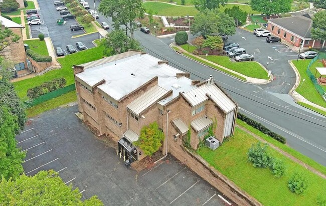
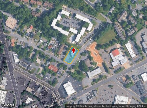
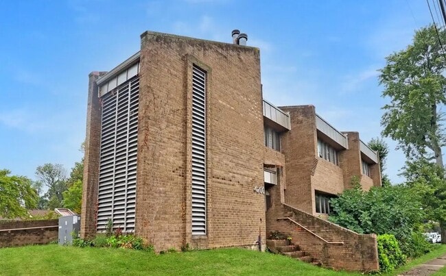

This Property Is For Sale
NEARBY LISTINGS FOR SALE OR LEASE
Property Detail
4200 Daniels Ave
Washington-Arlington-Alexandria, DC-VA-MD-WV
Annandale
0711-04-0107
ANNANDALE LTS 107 108
Officebuilding
Fairfax
X
Virginia
5100540050D
107
0
0.46 AC
2025
Annandale
450800
Washington, DC
8,202 SF
DEMOGRAPHICS near 4200 Daniels Ave
1 Mile
3 Mile
5 Mile
2024 Total Population
20,619
127,780
454,506
2029 Population
20,342
125,853
447,744
Pop Growth 2024-2029
(1.34%)
(1.51%)
(1.49%)
Average Age
40
40
39
2024 Total Households
6,582
42,391
169,830
HH Growth 2024-2029
(1.52%)
(1.66%)
(1.61%)
Median Household Inc
$102,242
$120,736
$114,631
Avg Household Size
3.00
2.90
2.60
2024 Avg HH Vehicles
2.00
2.00
2.00
Median Home Value
$651,505
$662,908
$655,153
Median Year Built
1966
1966
1972
Nearby Places
- Restaurants
- Banks
- Shops
- Fitness
- Groceries
PUBLIC TRANSPORTATION
COMMUTER RAIL
Backlick Road (Manassas Line - Virginia Railway Express)
DRIVE
WALK
Distance
Backlick Road (Manassas Line - Virginia Railway Express)
7 min
2.9 mi
Rolling Road (Manassas Line - Virginia Railway Express)
DRIVE
WALK
Distance
Rolling Road (Manassas Line - Virginia Railway Express)
12 min
5.9 mi
AIRPORT
Ronald Reagan Washington Ntl
DRIVE
WALK
Distance
Ronald Reagan Washington Ntl
19 min
10.3 mi
Washington Dulles International
DRIVE
WALK
Distance
Washington Dulles International
37 min
23.1 mi
Freight Ports
Port of Baltimore
DRIVE
WALK
Distance
Port of Baltimore
75 min
54.8 mi
Nearby Properties
Address
Land Use
TOTAL SIZE
Lot Size
Zoning
Address
Land Use
TOTAL SIZE
Lot Size
Zoning
1,434,346 SF
29.59 AC
430
Address
Land Use
TOTAL SIZE
Lot Size
Zoning
829,629 SF
21.30 AC
430
Address
Land Use
TOTAL SIZE
Lot Size
Zoning
1,464,969 SF
39.52 AC
403
Address
Land Use
TOTAL SIZE
Lot Size
Zoning
613,844 SF
499
Address
Land Use
TOTAL SIZE
Lot Size
Zoning
463,979 SF
19.23 AC
220
Address
Land Use
TOTAL SIZE
Lot Size
Zoning
1,031,040 SF
36.16 AC
220
Address
Land Use
TOTAL SIZE
Lot Size
Zoning
853,724 SF
32.32 AC
220
Address
Land Use
TOTAL SIZE
Lot Size
Zoning
429,735 SF
20 AC
560
Address
Land Use
TOTAL SIZE
Lot Size
Zoning
440,979 SF
20 AC
530
Address
Land Use
TOTAL SIZE
Lot Size
Zoning
431,097 SF
16.45 AC
220
Address
Land Use
TOTAL SIZE
Lot Size
Zoning
452,682 SF
20.74 AC
220
Address
Land Use
TOTAL SIZE
Lot Size
Zoning
415,368 SF
21.06 AC
220
Address
Land Use
TOTAL SIZE
Lot Size
Zoning
401,218 SF
13.78 AC
403
Address
Land Use
TOTAL SIZE
Lot Size
Zoning
485,839 SF
22.59 AC
460
Address
Land Use
TOTAL SIZE
Lot Size
Zoning
358,898 SF
6.44 AC
403
Address
Land Use
TOTAL SIZE
Lot Size
Zoning
485,499 SF
19.11 AC
220
Address
Land Use
TOTAL SIZE
Lot Size
Zoning
12.46 AC
220
Address
Land Use
TOTAL SIZE
Lot Size
Zoning
14.97 AC
220
Address
Land Use
TOTAL SIZE
Lot Size
Zoning
264,495 SF
15.55 AC
403
Address
Land Use
TOTAL SIZE
Lot Size
Zoning
461,369 SF
11.10 AC
403
Address
Land Use
TOTAL SIZE
Lot Size
Zoning
253,647 SF
5.99 AC
220
Address
Land Use
TOTAL SIZE
Lot Size
Zoning
308,062 SF
5.15 AC
403
Address
Land Use
TOTAL SIZE
Lot Size
Zoning
726,520 SF
12.37 AC
220
Address
Land Use
TOTAL SIZE
Lot Size
Zoning
339,028 SF
75.81 AC
120
Address
Land Use
TOTAL SIZE
Lot Size
Zoning
Address
Land Use
TOTAL SIZE
Lot Size
Zoning
398,419 SF
18.54 AC
560
Address
Land Use
TOTAL SIZE
Lot Size
Zoning
13.47 AC
220
Address
Land Use
TOTAL SIZE
Lot Size
Zoning
124,351 SF
14.60 AC
460
Address
Land Use
TOTAL SIZE
Lot Size
Zoning
153,341 SF
11.96 AC
460
Address
Land Use
TOTAL SIZE
Lot Size
Zoning
253,648 SF
10.72 AC
550
The World's #1 Commercial Real Estate Marketplace
Connect with us
© 2025 CoStar Group
The information above has been obtained from sources believed reliable. While we do not doubt its accuracy we have not verified it and make no guarantee, warranty or representation about it. It is your responsibility to independently confirm its accuracy and completeness. Any projections, opinions, assumptions, or estimates used are for example only and do not represent the current or future performance of the property. The value of this transaction to you depends on tax and other factors which should be evaluated by your tax, financial, and legal advisors. You and your advisors should conduct a careful, independent investigation of the property to determine to your satisfaction the suitability of the property for your needs.