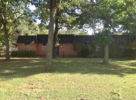
Property Record
4200 E Britton Rd, Oklahoma City, OK 73131

Property Detail
4200 E Britton Rd
141611000
UNPLTD PT SEC 31 13N 2W 000 000 PT NE4 SEC 31 13N 2W BEG AT NE/C OF NE4 TH S355FT W845.14FT NELY223.86FT NWLY180.90FT TO N LINE OF NE4 E742FT TO BEG
Commercialacreage
Oklahoma
AA
Oklahoma
AE The base floodplain where base flood elevations are provided. AE Zones are now used on new format FIRMs instead of A1-A30 Zones.
6.47 AC
2024
East Oklahoma County
2025
Oklahoma City
108101
Oklahoma City, OK
2,459 SF
NEARBY LISTINGS FOR SALE OR LEASE
-
-
View all Oklahoma City listings for lease on LoopNet.com
DEMOGRAPHICS near 4200 E Britton Rd
1 mile
3 mile
5 mile
2025 Total Population
498
7,983
54,390
2030 Population
514
8,167
55,747
Pop Growth 2025-2030
+ 3.21%
+ 2.30%
+ 2.49%
Average Age
38
42
39
2025 Total Households
151
2,815
21,282
HH Growth 2025-2030
+ 3.31%
+ 2.42%
+ 2.57%
Median Household Inc
$239,785
$130,013
$72,307
Avg Household Size
3.20
2.70
2.40
2025 Avg HH Vehicles
3.00
2.00
2.00
Median Home Value
$824,999
$648,258
$307,328
Median Year Built
2009
1999
1980
Nearby Places
Map Layers
Map Styles
 Street
 Aerial
Layers
 Traffic
 Biking
Places
Listings with unknown addresses are not visible on the map
- Restaurants
- Banks
- Shops
- Fitness
- Groceries
PUBLIC TRANSPORTATION
AIRPORT
Will Rogers World
Drive
Walk
Distance
Will Rogers World
32 min
19.4 mi
SALE & LEASE HISTORY
LISTING DATE
SALE/LEASE

Sep 25, 2016
For Lease
Sep 24, 2016
For Sale
Nearby Properties
Address
Land Use
TOTAL SIZE
Lot Size
Zoning
Address
Land Use
TOTAL SIZE
Lot Size
Zoning
322,252 SF
36.89 AC
PUD
Address
Land Use
TOTAL SIZE
Lot Size
Zoning
280,970 SF
24.32 AC
PUD
Address
Land Use
TOTAL SIZE
Lot Size
Zoning
145,124 SF
55 AC
PUD
Address
Land Use
TOTAL SIZE
Lot Size
Zoning
316,358 SF
39.39 AC
PUD
Address
Land Use
TOTAL SIZE
Lot Size
Zoning
39,800 SF
4.10 AC
PUD
Address
Land Use
TOTAL SIZE
Lot Size
Zoning
160,816 SF
16.14 AC
Address
Land Use
TOTAL SIZE
Lot Size
Zoning
220,800 SF
14.55 AC
PUD
Address
Land Use
TOTAL SIZE
Lot Size
Zoning
214,478 SF
22 AC
PUD
Address
Land Use
TOTAL SIZE
Lot Size
Zoning
131,180 SF
12.90 AC
I-2
Address
Land Use
TOTAL SIZE
Lot Size
Zoning
46,390 SF
14.13 AC
Address
Land Use
TOTAL SIZE
Lot Size
Zoning
145,600 SF
16.38 AC
PUD
Address
Land Use
TOTAL SIZE
Lot Size
Zoning
125,440 SF
10.92 AC
PUD
Address
Land Use
TOTAL SIZE
Lot Size
Zoning
39,997 SF
9.45 AC
C-4
Address
Land Use
TOTAL SIZE
Lot Size
Zoning
4,479 SF
0.18 AC
PUD
Address
Land Use
TOTAL SIZE
Lot Size
Zoning
7,360 SF
4.69 AC
SPUD
Address
Land Use
TOTAL SIZE
Lot Size
Zoning
49,006 SF
29.61 AC
PUD
Address
Land Use
TOTAL SIZE
Lot Size
Zoning
88,116 SF
38.22 AC
C-3
Address
Land Use
TOTAL SIZE
Lot Size
Zoning
45,414 SF
1.79 AC
SPUD
Address
Land Use
TOTAL SIZE
Lot Size
Zoning
99,577 SF
8.09 AC
PUD
Address
Land Use
TOTAL SIZE
Lot Size
Zoning
138,600 SF
9.30 AC
PUD
Address
Land Use
TOTAL SIZE
Lot Size
Zoning
68,287 SF
6.13 AC
O-1
Address
Land Use
TOTAL SIZE
Lot Size
Zoning
76,660 SF
4.97 AC
PUD
Address
Land Use
TOTAL SIZE
Lot Size
Zoning
50,588 SF
1.30 AC
PUD
Address
Land Use
TOTAL SIZE
Lot Size
Zoning
89,079 SF
20.49 AC
PUD
Address
Land Use
TOTAL SIZE
Lot Size
Zoning
32,717 SF
85 AC
AA
Address
Land Use
TOTAL SIZE
Lot Size
Zoning
156,300 SF
24.99 AC
PUD
Address
Land Use
TOTAL SIZE
Lot Size
Zoning
18,601 SF
20.92 AC
PUD
Address
Land Use
TOTAL SIZE
Lot Size
Zoning
37,738 SF
2.27 AC
C-4
Address
Land Use
TOTAL SIZE
Lot Size
Zoning
45,408 SF
14.32 AC
SPUD
The World's #1 Commercial Real Estate Marketplace
Connect with us
© 2026 CoStar Group
The information above has been obtained from sources believed reliable. While we do not doubt its accuracy we have not verified it and make no guarantee, warranty or representation about it. It is your responsibility to independently confirm its accuracy and completeness. Any projections, opinions, assumptions, or estimates used are for example only and do not represent the current or future performance of the property. The value of this transaction to you depends on tax and other factors which should be evaluated by your tax, financial, and legal advisors. You and your advisors should conduct a careful, independent investigation of the property to determine to your satisfaction the suitability of the property for your needs.