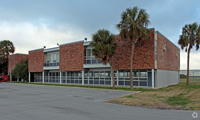
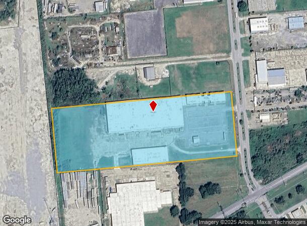
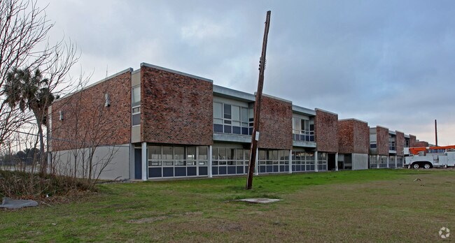
Property Record
4200 Michoud Blvd, New Orleans, LA 70129
NEARBY LISTINGS FOR SALE OR LEASE
Property Detail
4200 Michoud Blvd
New Orleans-Metairie, LA
Noeic D
3-9W-9-559-04
SQ E LOT 2-XY-2 MICHOUD THRU OLD GENTILLY 437/436 X 1206/1216 12.185 AC 2/ST BR OFFICE BLG& WHSE-2/ST BR METAL WHSE PLAN 9-14A-66
Warehouse
Orleans
X
Louisiana
22087C0225D
2xy2
2025
12.19 AC
2025
New Orleans East
001751
New Orleans/Metairie/Kenner
156,153 SF
DEMOGRAPHICS near 4200 Michoud Blvd
1 Mile
3 Mile
5 Mile
2024 Total Population
1,410
22,742
59,731
2029 Population
1,346
21,564
56,834
Pop Growth 2024-2029
(4.54%)
(5.18%)
(4.85%)
Average Age
41
40
39
2024 Total Households
446
8,024
21,510
HH Growth 2024-2029
(4.71%)
(5.35%)
(5.14%)
Median Household Inc
$29,317
$44,196
$35,448
Avg Household Size
3.00
2.70
2.70
2024 Avg HH Vehicles
2.00
2.00
1.00
Median Home Value
$155,882
$190,479
$177,646
Median Year Built
1974
1979
1977
Nearby Places
Map Layers
Map Styles
 Street
 Aerial
- Restaurants
- Banks
- Shops
- Fitness
- Groceries
PUBLIC TRANSPORTATION
AIRPORT
Louis Armstrong New Orleans International
DRIVE
WALK
Distance
Louis Armstrong New Orleans International
37 min
23.9 mi
Freight Ports
Port of New Orleans
DRIVE
WALK
Distance
Port of New Orleans
30 min
16.2 mi
SALE & LEASE HISTORY
LISTING DATE
SALE/LEASE

Sep 25, 2016
For Lease
May 25, 2021
For Sale
Nearby Properties
Address
Land Use
TOTAL SIZE
Lot Size
Zoning
Address
Land Use
TOTAL SIZE
Lot Size
Zoning
Address
Land Use
TOTAL SIZE
Lot Size
Zoning
286.90 AC
HI
Address
Land Use
TOTAL SIZE
Lot Size
Zoning
139.95 AC
Address
Land Use
TOTAL SIZE
Lot Size
Zoning
109,239 SF
5.77 AC
S-RS
Address
Land Use
TOTAL SIZE
Lot Size
Zoning
115,600 SF
16.96 AC
S-B2
Address
Land Use
TOTAL SIZE
Lot Size
Zoning
42.84 AC
HI
Address
Land Use
TOTAL SIZE
Lot Size
Zoning
95,308 SF
16.36 AC
S-RS
Address
Land Use
TOTAL SIZE
Lot Size
Zoning
13,302 SF
53.89 AC
OS-R
Address
Land Use
TOTAL SIZE
Lot Size
Zoning
9.27 AC
S-B2
Address
Land Use
TOTAL SIZE
Lot Size
Zoning
20.58 AC
S-RS
Address
Land Use
TOTAL SIZE
Lot Size
Zoning
42.84 AC
HI
Address
Land Use
TOTAL SIZE
Lot Size
Zoning
179,095 SF
18.13 AC
C-3
Address
Land Use
TOTAL SIZE
Lot Size
Zoning
205,380 SF
16.49 AC
MS
Address
Land Use
TOTAL SIZE
Lot Size
Zoning
13,563 SF
81.46 AC
OS-R
Address
Land Use
TOTAL SIZE
Lot Size
Zoning
33.59 AC
S-RS
Address
Land Use
TOTAL SIZE
Lot Size
Zoning
19.84 AC
BIP
Address
Land Use
TOTAL SIZE
Lot Size
Zoning
4.09 AC
S-RD
Address
Land Use
TOTAL SIZE
Lot Size
Zoning
42.84 AC
HI
Address
Land Use
TOTAL SIZE
Lot Size
Zoning
65,184 SF
1.73 AC
C-2
Address
Land Use
TOTAL SIZE
Lot Size
Zoning
1.05 AC
C-3
Address
Land Use
TOTAL SIZE
Lot Size
Zoning
347,544 SF
16.54 AC
S-RM2
Address
Land Use
TOTAL SIZE
Lot Size
Zoning
48,692 SF
2.32 AC
C-3
Address
Land Use
TOTAL SIZE
Lot Size
Zoning
464,756 SF
10.04 AC
S-RM2
Address
Land Use
TOTAL SIZE
Lot Size
Zoning
32,890 SF
1.80 AC
MS
Address
Land Use
TOTAL SIZE
Lot Size
Zoning
138.16 AC
HI
Address
Land Use
TOTAL SIZE
Lot Size
Zoning
13,363 SF
2.40 AC
C-3
Address
Land Use
TOTAL SIZE
Lot Size
Zoning
88,360 SF
10.53 AC
S-RM2
Address
Land Use
TOTAL SIZE
Lot Size
Zoning
6.83 AC
S-RS
Address
Land Use
TOTAL SIZE
Lot Size
Zoning
110,450 SF
10.50 AC
S-RM2
Address
Land Use
TOTAL SIZE
Lot Size
Zoning
1.86 AC
S-RS
The World's #1 Commercial Real Estate Marketplace
Connect with us
© 2025 CoStar Group
The information above has been obtained from sources believed reliable. While we do not doubt its accuracy we have not verified it and make no guarantee, warranty or representation about it. It is your responsibility to independently confirm its accuracy and completeness. Any projections, opinions, assumptions, or estimates used are for example only and do not represent the current or future performance of the property. The value of this transaction to you depends on tax and other factors which should be evaluated by your tax, financial, and legal advisors. You and your advisors should conduct a careful, independent investigation of the property to determine to your satisfaction the suitability of the property for your needs.