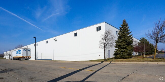
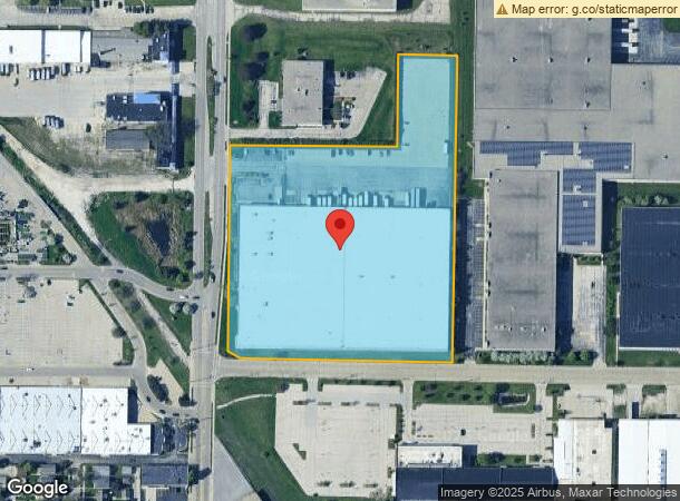
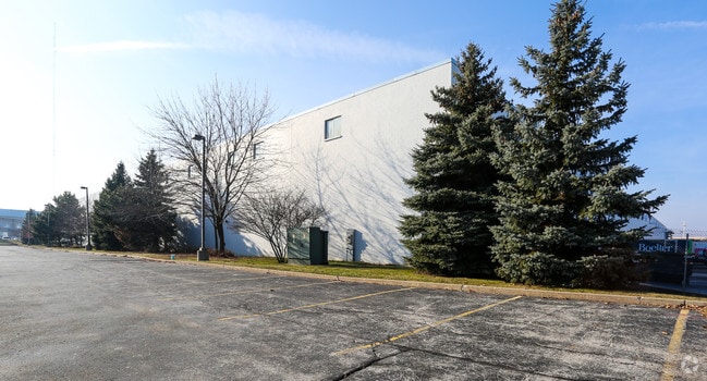
Property Record
4200 N Port Washington Rd, Milwaukee, WI 53212
NEARBY LISTINGS FOR SALE OR LEASE
Property Detail
4200 N Port Washington Rd
Milwaukee-Waukesha-West Allis, WI
Certified Surv Map 6466
242-8005-000
CERTIFIED SUR MAP #6466 DOC #7482399 CERTIFIED SUR MAP #6465 DOC #7481145 & PART PCL1 CERTIFIED SUR
Commercialnec
Milwaukee
X
Wisconsin
55079C0100E
1
2024
8.09 AC
2024
Milwaukee East
060200
Milwaukee/Madison
194,400 SF
DEMOGRAPHICS near 4200 N Port Washington Rd
1 Mile
3 Mile
5 Mile
2024 Total Population
15,002
171,392
350,448
2029 Population
14,883
169,222
345,554
Pop Growth 2024-2029
(0.79%)
(1.27%)
(1.40%)
Average Age
37
36
36
2024 Total Households
6,054
72,341
149,941
HH Growth 2024-2029
(0.97%)
(1.49%)
(1.46%)
Median Household Inc
$45,736
$43,821
$46,358
Avg Household Size
2.40
2.20
2.20
2024 Avg HH Vehicles
1.00
1.00
1.00
Median Home Value
$131,037
$199,795
$189,447
Median Year Built
1948
1947
1949
Nearby Places
Map Layers
Map Styles
 Street
 Aerial
- Restaurants
- Banks
- Shops
- Fitness
- Groceries
PUBLIC TRANSPORTATION
COMMUTER RAIL
Milwaukee (Empire Builder - Amtrak)
DRIVE
WALK
Distance
Milwaukee (Empire Builder - Amtrak)
10 min
4.9 mi
AIRPORT
General Mitchell International
DRIVE
WALK
Distance
General Mitchell International
21 min
11.5 mi
Freight Ports
Port Milwaukee
DRIVE
WALK
Distance
Port Milwaukee
13 min
7.3 mi
Nearby Properties
Address
Land Use
TOTAL SIZE
Lot Size
Zoning
Address
Land Use
TOTAL SIZE
Lot Size
Zoning
26.11 AC
TL
Address
Land Use
TOTAL SIZE
Lot Size
Zoning
417,704 SF
0.81 AC
PD
Address
Land Use
TOTAL SIZE
Lot Size
Zoning
382,921 SF
2.81 AC
PD
Address
Land Use
TOTAL SIZE
Lot Size
Zoning
42.90 AC
TL
Address
Land Use
TOTAL SIZE
Lot Size
Zoning
508,168 SF
14.56 AC
C9G
Address
Land Use
TOTAL SIZE
Lot Size
Zoning
162,000 SF
0.83 AC
PD
Address
Land Use
TOTAL SIZE
Lot Size
Zoning
305,573 SF
3.20 AC
Address
Land Use
TOTAL SIZE
Lot Size
Zoning
66,245 SF
10.21 AC
Address
Land Use
TOTAL SIZE
Lot Size
Zoning
527,776 SF
33.23 AC
Address
Land Use
TOTAL SIZE
Lot Size
Zoning
0.09 AC
LB2
Address
Land Use
TOTAL SIZE
Lot Size
Zoning
0.07 AC
RS6
Address
Land Use
TOTAL SIZE
Lot Size
Zoning
12.97 AC
TL
Address
Land Use
TOTAL SIZE
Lot Size
Zoning
85,000 SF
1.13 AC
Address
Land Use
TOTAL SIZE
Lot Size
Zoning
685,390 SF
26.20 AC
Address
Land Use
TOTAL SIZE
Lot Size
Zoning
1 SF
5.12 AC
PD
Address
Land Use
TOTAL SIZE
Lot Size
Zoning
152,640 SF
10.50 AC
Address
Land Use
TOTAL SIZE
Lot Size
Zoning
171,170 SF
25.88 AC
Address
Land Use
TOTAL SIZE
Lot Size
Zoning
12.74 AC
TL
Address
Land Use
TOTAL SIZE
Lot Size
Zoning
193,988 SF
1.28 AC
C9G
Address
Land Use
TOTAL SIZE
Lot Size
Zoning
214,461 SF
0.49 AC
PD
Address
Land Use
TOTAL SIZE
Lot Size
Zoning
224,756 SF
12 AC
RESIDENTIA
Address
Land Use
TOTAL SIZE
Lot Size
Zoning
145,605 SF
2.64 AC
Address
Land Use
TOTAL SIZE
Lot Size
Zoning
241,520 SF
6.60 AC
Address
Land Use
TOTAL SIZE
Lot Size
Zoning
110,011 SF
0.59 AC
PD
Address
Land Use
TOTAL SIZE
Lot Size
Zoning
27.05 AC
PK
Address
Land Use
TOTAL SIZE
Lot Size
Zoning
165,296 SF
1.04 AC
Address
Land Use
TOTAL SIZE
Lot Size
Zoning
294,553 SF
6.19 AC
Address
Land Use
TOTAL SIZE
Lot Size
Zoning
113,542 SF
2.31 AC
Address
Land Use
TOTAL SIZE
Lot Size
Zoning
213,218 SF
11 AC
Address
Land Use
TOTAL SIZE
Lot Size
Zoning
154,494 SF
0.83 AC
PD
The World's #1 Commercial Real Estate Marketplace
Connect with us
© 2025 CoStar Group
The information above has been obtained from sources believed reliable. While we do not doubt its accuracy we have not verified it and make no guarantee, warranty or representation about it. It is your responsibility to independently confirm its accuracy and completeness. Any projections, opinions, assumptions, or estimates used are for example only and do not represent the current or future performance of the property. The value of this transaction to you depends on tax and other factors which should be evaluated by your tax, financial, and legal advisors. You and your advisors should conduct a careful, independent investigation of the property to determine to your satisfaction the suitability of the property for your needs.