Property Record
4200 Nazareth Rd, Kalamazoo, MI 49004
NEARBY LISTINGS FOR SALE OR LEASE
-
-
View all Kalamazoo listings for sale on LoopNet.com
Property Detail
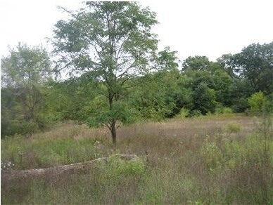
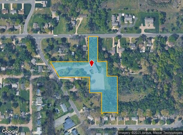
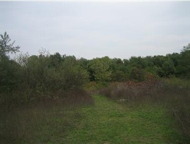
4200 Nazareth Rd
06-01-205-031
1000120 3906 01 205 031 SEC 1-2-11 COM AT THE N 1/4 POST SECTION 1 TH N 89 DEG 35 MIN E ALG N LI SD SEC 443.89 FT FOR POB TH
Commercialnec
Kalamazoo
X
Michigan
26077C0185E
4
2024
3.80 AC
2025
NE Kalamazoo County
005502
West Michigan
4,667 SF
Kalamazoo-Portage, MI
DEMOGRAPHICS near 4200 Nazareth Rd
1 Mile
3 Mile
5 Mile
2024 Total Population
7,013
31,294
77,917
2029 Population
7,008
31,214
78,052
Pop Growth 2024-2029
(0.07%)
(0.26%)
+ 0.17%
Average Age
38
38
37
2024 Total Households
3,294
13,026
31,759
HH Growth 2024-2029
(0.03%)
(0.28%)
+ 0.20%
Median Household Inc
$58,499
$55,357
$50,086
Avg Household Size
2.10
2.30
2.30
2024 Avg HH Vehicles
2.00
2.00
2.00
Median Home Value
$157,190
$149,157
$151,812
Median Year Built
1985
1964
1957
Nearby Places
Map Layers
Map Styles
 Street
 Aerial
- Restaurants
- Banks
- Shops
- Fitness
- Groceries
PUBLIC TRANSPORTATION
COMMUTER RAIL
Kalamazoo (Blue Water - Amtrak, Wolverine - Amtrak)
DRIVE
WALK
Distance
Kalamazoo (Blue Water - Amtrak, Wolverine - Amtrak)
9 min
4.3 mi
AIRPORT
Kalamazoo/Battle Creek International
DRIVE
WALK
Distance
Kalamazoo/Battle Creek International
21 min
9.0 mi
Freight Ports
Port of Toledo
DRIVE
WALK
Distance
Port of Toledo
178 min
145.5 mi
Nearby Properties
Address
Land Use
TOTAL SIZE
Lot Size
Zoning
Address
Land Use
TOTAL SIZE
Lot Size
Zoning
877,422 SF
38.18 AC
M-2
Address
Land Use
TOTAL SIZE
Lot Size
Zoning
20.94 AC
Address
Land Use
TOTAL SIZE
Lot Size
Zoning
390,900 SF
14 AC
I-M IND
Address
Land Use
TOTAL SIZE
Lot Size
Zoning
185,107 SF
25.12 AC
RM
Address
Land Use
TOTAL SIZE
Lot Size
Zoning
196,221 SF
26.26 AC
RM
Address
Land Use
TOTAL SIZE
Lot Size
Zoning
185,092 SF
26.86 AC
RM
Address
Land Use
TOTAL SIZE
Lot Size
Zoning
12.58 AC
Address
Land Use
TOTAL SIZE
Lot Size
Zoning
274,412 SF
12.10 AC
RM-1
Address
Land Use
TOTAL SIZE
Lot Size
Zoning
226,051 SF
44.98 AC
B-2
Address
Land Use
TOTAL SIZE
Lot Size
Zoning
217,600 SF
21.30 AC
N/A
Address
Land Use
TOTAL SIZE
Lot Size
Zoning
133,600 SF
15.08 AC
B-1
Address
Land Use
TOTAL SIZE
Lot Size
Zoning
193,194 SF
23.96 AC
B-3
Address
Land Use
TOTAL SIZE
Lot Size
Zoning
99,017 SF
9.42 AC
RM
Address
Land Use
TOTAL SIZE
Lot Size
Zoning
185,528 SF
17.20 AC
R5
Address
Land Use
TOTAL SIZE
Lot Size
Zoning
98,360 SF
13.58 AC
R4
Address
Land Use
TOTAL SIZE
Lot Size
Zoning
143,760 SF
10.25 AC
M-2
Address
Land Use
TOTAL SIZE
Lot Size
Zoning
118,104 SF
10.40 AC
R4
Address
Land Use
TOTAL SIZE
Lot Size
Zoning
9.65 AC
RM-36
Address
Land Use
TOTAL SIZE
Lot Size
Zoning
49,216 SF
2.90 AC
RM-2
Address
Land Use
TOTAL SIZE
Lot Size
Zoning
8,214 SF
2.39 AC
C-3 GEN
Address
Land Use
TOTAL SIZE
Lot Size
Zoning
155,756 SF
0.67 AC
RM-2
Address
Land Use
TOTAL SIZE
Lot Size
Zoning
236,922 SF
13.32 AC
M-2
Address
Land Use
TOTAL SIZE
Lot Size
Zoning
102,300 SF
10.12 AC
B-1
Address
Land Use
TOTAL SIZE
Lot Size
Zoning
84,360 SF
5.31 AC
R4
Address
Land Use
TOTAL SIZE
Lot Size
Zoning
53,003 SF
3.20 AC
RM-36
Address
Land Use
TOTAL SIZE
Lot Size
Zoning
112,736 SF
15.84 AC
R-1C
Address
Land Use
TOTAL SIZE
Lot Size
Zoning
109,892 SF
12.24 AC
RM-1
Address
Land Use
TOTAL SIZE
Lot Size
Zoning
2,164 SF
3.48 AC
B-2
Address
Land Use
TOTAL SIZE
Lot Size
Zoning
42,649 SF
3.22 AC
CN-1
Address
Land Use
TOTAL SIZE
Lot Size
Zoning
The World's #1 Commercial Real Estate Marketplace
Connect with us
© 2025 CoStar Group
The information above has been obtained from sources believed reliable. While we do not doubt its accuracy we have not verified it and make no guarantee, warranty or representation about it. It is your responsibility to independently confirm its accuracy and completeness. Any projections, opinions, assumptions, or estimates used are for example only and do not represent the current or future performance of the property. The value of this transaction to you depends on tax and other factors which should be evaluated by your tax, financial, and legal advisors. You and your advisors should conduct a careful, independent investigation of the property to determine to your satisfaction the suitability of the property for your needs.