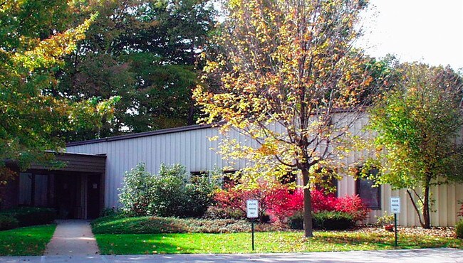
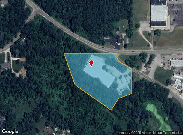
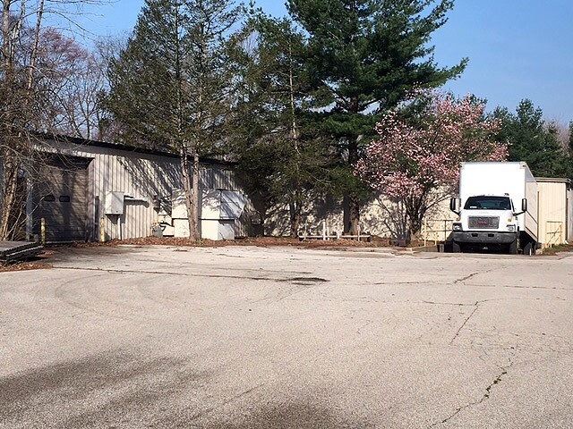
Property Record
63 M, Saint Joseph, MI 49085
NEARBY LISTINGS FOR SALE OR LEASE
Property Detail
63 M
11-17-0018-0017-01-2
The Oaks Subdivision #4
Manufacturinglight
COM 942.05'W OF NE COR FRL SEC 18 T5S R18W TH S 59 DEG 39'E 326.45' S 0 DEG 22'W 208' S 70 DEG 38'W 133.6' S 36 DEG 26'W 131.64'TO C/L YELLOW CR NW'LY ON C/L TO N SEC LINE TH E 377.37'TO POB PER UNREC SURVEY & SURVEY 1233/452
AE
Berrien
26021C0112C
Michigan
2024
5.10 AC
2025
Michigan Southwest Area
001100
Other Market Areas
46,251 SF
Niles-Benton Harbor, MI
DEMOGRAPHICS near 63 M
1 Mile
3 Mile
5 Mile
2024 Total Population
1,665
16,260
49,936
2029 Population
1,605
15,797
48,972
Pop Growth 2024-2029
(3.60%)
(2.85%)
(1.93%)
Average Age
44
43
41
2024 Total Households
573
6,557
20,714
HH Growth 2024-2029
(4.01%)
(2.99%)
(2.19%)
Median Household Inc
$102,885
$83,062
$60,646
Avg Household Size
2.60
2.40
2.30
2024 Avg HH Vehicles
2.00
2.00
2.00
Median Home Value
$287,373
$235,998
$219,698
Median Year Built
1979
1971
1966
Nearby Places
Map Layers
Map Styles
 Street
 Aerial
- Restaurants
- Banks
- Shops
- Fitness
- Groceries
PUBLIC TRANSPORTATION
COMMUTER RAIL
St. Joseph-Benton Harbor Amtrak Station (Pere Marquette - Amtrak)
DRIVE
WALK
Distance
St. Joseph-Benton Harbor Amtrak Station (Pere Marquette - Amtrak)
12 min
6.2 mi
AIRPORT
South Bend International
DRIVE
WALK
Distance
South Bend International
43 min
28.8 mi
Freight Ports
Port Milwaukee
DRIVE
WALK
Distance
Port Milwaukee
217 min
180.8 mi
SALE & LEASE HISTORY
LISTING DATE
SALE/LEASE

Sep 25, 2016
For Lease
May 12, 2017
For Sale
Nearby Properties
Address
Land Use
TOTAL SIZE
Lot Size
Zoning
Address
Land Use
TOTAL SIZE
Lot Size
Zoning
200,321 SF
15.47 AC
D1 COMM
Address
Land Use
TOTAL SIZE
Lot Size
Zoning
87,978 SF
4.36 AC
R2 MDR
Address
Land Use
TOTAL SIZE
Lot Size
Zoning
218,334 SF
25.05 AC
Address
Land Use
TOTAL SIZE
Lot Size
Zoning
69,180 SF
3.58 AC
D1 COMM
Address
Land Use
TOTAL SIZE
Lot Size
Zoning
73,505 SF
4.02 AC
D1 COMM
Address
Land Use
TOTAL SIZE
Lot Size
Zoning
66,680 SF
3.42 AC
Address
Land Use
TOTAL SIZE
Lot Size
Zoning
258,549 SF
17.20 AC
C MULTI
Address
Land Use
TOTAL SIZE
Lot Size
Zoning
62,800 SF
3.06 AC
Address
Land Use
TOTAL SIZE
Lot Size
Zoning
53,504 SF
Address
Land Use
TOTAL SIZE
Lot Size
Zoning
171,165 SF
15.15 AC
D1 COMM
Address
Land Use
TOTAL SIZE
Lot Size
Zoning
61,732 SF
3.51 AC
D1 COMM
Address
Land Use
TOTAL SIZE
Lot Size
Zoning
42,610 SF
5.30 AC
C4 HEAVY
Address
Land Use
TOTAL SIZE
Lot Size
Zoning
112,503 SF
4.30 AC
C MULTI FA
Address
Land Use
TOTAL SIZE
Lot Size
Zoning
45,270 SF
10.30 AC
C1 GEN COM
Address
Land Use
TOTAL SIZE
Lot Size
Zoning
126,127 SF
11.84 AC
D1 COMM
Address
Land Use
TOTAL SIZE
Lot Size
Zoning
391,928 SF
40.84 AC
F HEAVY
Address
Land Use
TOTAL SIZE
Lot Size
Zoning
84,732 SF
4.19 AC
C MULTI FA
Address
Land Use
TOTAL SIZE
Lot Size
Zoning
254,984 SF
25.04 AC
R-A RE
Address
Land Use
TOTAL SIZE
Lot Size
Zoning
49,527 SF
4.47 AC
PUD
Address
Land Use
TOTAL SIZE
Lot Size
Zoning
103,591 SF
8.77 AC
D1 COMM
Address
Land Use
TOTAL SIZE
Lot Size
Zoning
18.05 AC
D1 COMM
Address
Land Use
TOTAL SIZE
Lot Size
Zoning
60,188 SF
3.59 AC
D1 COMM
Address
Land Use
TOTAL SIZE
Lot Size
Zoning
172,489 SF
12.66 AC
E RESTRICT
Address
Land Use
TOTAL SIZE
Lot Size
Zoning
23,923 SF
2.40 AC
D1 COMM
Address
Land Use
TOTAL SIZE
Lot Size
Zoning
9,136 SF
79.96 AC
MH
Address
Land Use
TOTAL SIZE
Lot Size
Zoning
32,066 SF
4.44 AC
Address
Land Use
TOTAL SIZE
Lot Size
Zoning
23,234 SF
3.94 AC
PUD
Address
Land Use
TOTAL SIZE
Lot Size
Zoning
46,584 SF
12.19 AC
D1 COMM
Address
Land Use
TOTAL SIZE
Lot Size
Zoning
29,032 SF
4.62 AC
C1 GEN COM
Address
Land Use
TOTAL SIZE
Lot Size
Zoning
1,036 SF
34.40 AC
R-A RE
The World's #1 Commercial Real Estate Marketplace
Connect with us
© 2025 CoStar Group
The information above has been obtained from sources believed reliable. While we do not doubt its accuracy we have not verified it and make no guarantee, warranty or representation about it. It is your responsibility to independently confirm its accuracy and completeness. Any projections, opinions, assumptions, or estimates used are for example only and do not represent the current or future performance of the property. The value of this transaction to you depends on tax and other factors which should be evaluated by your tax, financial, and legal advisors. You and your advisors should conduct a careful, independent investigation of the property to determine to your satisfaction the suitability of the property for your needs.