Property Record
4200 S Othello St, Seattle, WA 98118

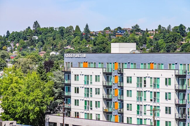
Property Detail
4200 S Othello St
880000-0035
E 70 FT OF S 100 FT OF POR OF NW 1/4 OF NW 1/4 OF SE 1/4 LY W OF 43RD AVE S & N OF OTHELLO ST LESS POR DEEDED TO C.P.S.R.T.A. UNDER REC NO 20030909002325
Apartment
King
NC3P-95 (M
Washington
B and X Area of moderate flood hazard, usually the area between the limits of the 100-year and 500-year floods.
b
2026
1.71 AC
2025
Brighton
011101
Seattle/Puget Sound
245,915 SF
Seattle-Tacoma-Bellevue, WA
NEARBY LISTINGS FOR SALE OR LEASE
DEMOGRAPHICS near 4200 S Othello St
1 mile
3 mile
5 mile
2025 Total Population
29,917
108,729
338,840
2030 Population
31,188
113,483
354,239
Pop Growth 2025-2030
+ 4.25%
+ 4.37%
+ 4.54%
Average Age
39
40
40
2025 Total Households
10,365
39,822
133,412
HH Growth 2025-2030
+ 4.43%
+ 4.50%
+ 4.71%
Median Household Inc
$95,463
$109,438
$106,659
Avg Household Size
2.70
2.60
2.40
2025 Avg HH Vehicles
2.00
2.00
2.00
Median Home Value
$776,740
$821,249
$807,582
Median Year Built
1969
1966
1973
Nearby Places
Map Layers
Map Styles
 Street
 Aerial
Layers
 Traffic
 Biking
Places
Listings with unknown addresses are not visible on the map
- Restaurants
- Banks
- Shops
- Fitness
- Groceries
PUBLIC TRANSPORTATION
TRANSIT/SUBWAY
ST Light Rail & Othello Station (SB) (LINK to Sea-Tac - Central Puget Sound Regional Transit Authority Rail (Link Light Rail/Sounder))
Drive
Walk
Distance
ST Light Rail & Othello Station (SB) (LINK to Sea-Tac - Central Puget Sound Regional Transit Authority Rail (Link Light Rail/Sounder))
1 min
2 min
0.1 mi
Othello (Central Link - Central Puget Sound Regional Transit Authority Rail (Link Light Rail/Sounder))
Drive
Walk
Distance
Othello (Central Link - Central Puget Sound Regional Transit Authority Rail (Link Light Rail/Sounder))
2 min
3 min
0.1 mi
COMMUTER RAIL
King Street (Seattle) Station (Sounder South Line - Central Puget Sound Regional Transit Authority Rail (Link Light Rail/Sounder))
Drive
Walk
Distance
King Street (Seattle) Station (Sounder South Line - Central Puget Sound Regional Transit Authority Rail (Link Light Rail/Sounder))
13 min
5.9 mi
AIRPORT
Seattle-Tacoma International
Drive
Walk
Distance
Seattle-Tacoma International
20 min
8.9 mi
Seattle Paine Field International
Drive
Walk
Distance
Seattle Paine Field International
45 min
29.8 mi
Freight Ports
Port of Seattle
Drive
Walk
Distance
Port of Seattle
15 min
5.8 mi
SALE & LEASE HISTORY
LISTING DATE
SALE/LEASE

Sep 25, 2016
For Lease
Nearby Properties
Address
Land Use
TOTAL SIZE
Lot Size
Zoning
Address
Land Use
TOTAL SIZE
Lot Size
Zoning
30,290 SF
564.80 AC
MML U/85
Address
Land Use
TOTAL SIZE
Lot Size
Zoning
2,800 SF
210.85 AC
NR1
Address
Land Use
TOTAL SIZE
Lot Size
Zoning
1,134 SF
53.17 AC
MIC/H
Address
Land Use
TOTAL SIZE
Lot Size
Zoning
147,878 SF
13.67 AC
MML U/85
Address
Land Use
TOTAL SIZE
Lot Size
Zoning
525,975 SF
37.45 AC
MML U/85
Address
Land Use
TOTAL SIZE
Lot Size
Zoning
141,643 SF
11.44 AC
MIC/H
Address
Land Use
TOTAL SIZE
Lot Size
Zoning
218,805 SF
51.21 AC
MIO-105-LR
Address
Land Use
TOTAL SIZE
Lot Size
Zoning
165,600 SF
24.58 AC
MIC/H
Address
Land Use
TOTAL SIZE
Lot Size
Zoning
164,256 SF
8.47 AC
LR2 (M)
Address
Land Use
TOTAL SIZE
Lot Size
Zoning
18,888 SF
85.89 AC
NR2
Address
Land Use
TOTAL SIZE
Lot Size
Zoning
166,212 SF
1.57 AC
NC2P-55 (M
Address
Land Use
TOTAL SIZE
Lot Size
Zoning
34.25 AC
MIC/H
Address
Land Use
TOTAL SIZE
Lot Size
Zoning
323,916 SF
10.33 AC
MML U/85
Address
Land Use
TOTAL SIZE
Lot Size
Zoning
241,186 SF
25.51 AC
MIC/H
Address
Land Use
TOTAL SIZE
Lot Size
Zoning
169,110 SF
29.99 AC
MIC/H
Address
Land Use
TOTAL SIZE
Lot Size
Zoning
460,477 SF
8.02 AC
MML U/85
Address
Land Use
TOTAL SIZE
Lot Size
Zoning
114,061 SF
19.92 AC
MML U/65
Address
Land Use
TOTAL SIZE
Lot Size
Zoning
31,737 SF
9.55 AC
RSL (M)
Address
Land Use
TOTAL SIZE
Lot Size
Zoning
102,424 SF
4.02 AC
LR3 (M)
Address
Land Use
TOTAL SIZE
Lot Size
Zoning
284,067 SF
14.36 AC
LI
Address
Land Use
TOTAL SIZE
Lot Size
Zoning
646 SF
10.69 AC
LI
Address
Land Use
TOTAL SIZE
Lot Size
Zoning
342,115 SF
14.12 AC
MIC/H
Address
Land Use
TOTAL SIZE
Lot Size
Zoning
10,614 SF
7.82 AC
NC2-55 (M)
Address
Land Use
TOTAL SIZE
Lot Size
Zoning
17,694 SF
13.87 AC
LR2 (M)
Address
Land Use
TOTAL SIZE
Lot Size
Zoning
4,329 SF
44.77 AC
NR3
Address
Land Use
TOTAL SIZE
Lot Size
Zoning
291,940 SF
9.08 AC
SM-NR 145
Address
Land Use
TOTAL SIZE
Lot Size
Zoning
21 AC
MML U/85
Address
Land Use
TOTAL SIZE
Lot Size
Zoning
103,931 SF
28.65 AC
MIC/H
Address
Land Use
TOTAL SIZE
Lot Size
Zoning
50,400 SF
8.43 AC
MML U/85
Address
Land Use
TOTAL SIZE
Lot Size
Zoning
180,775 SF
12.60 AC
MIC/H
The World's #1 Commercial Real Estate Marketplace
Connect with us
© 2026 CoStar Group
The information above has been obtained from sources believed reliable. While we do not doubt its accuracy we have not verified it and make no guarantee, warranty or representation about it. It is your responsibility to independently confirm its accuracy and completeness. Any projections, opinions, assumptions, or estimates used are for example only and do not represent the current or future performance of the property. The value of this transaction to you depends on tax and other factors which should be evaluated by your tax, financial, and legal advisors. You and your advisors should conduct a careful, independent investigation of the property to determine to your satisfaction the suitability of the property for your needs.