Property Record
4200 Wynndale Rd, Byram, MS 39170
NEARBY LISTINGS FOR SALE OR LEASE
-
-
View all Byram listings for sale on LoopNet.com
Property Detail
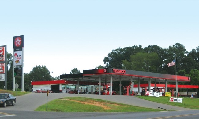
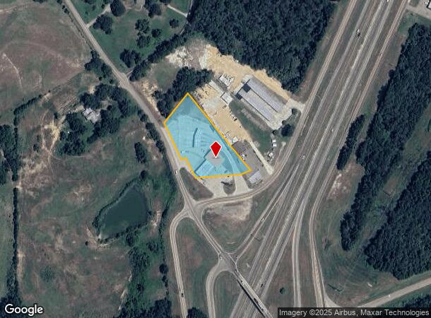
4200 Wynndale Rd
4850-0536-010
BEG 250.3 FT SELY INT S/L DEERFIELD RD & E/L WYNNDALE RD SELY 233.6 FT NELY 20 FT SELY 102.26 FT E 193.06 FT NELY 75.24 FT NWLY 499.19 FT SWLY 179 FT TO POB IN NW 1/4 NE 1/4 SEC 3 T3 R1W TOWN OF BYRAM
Servicestation
Hinds
X
Mississippi
28121C0295F
2 AC
2024
Outlying Hinds County
2025
Jackson
011204
Jackson, MS
3,500 SF
DEMOGRAPHICS near 4200 Wynndale Rd
1 Mile
3 Mile
5 Mile
2024 Total Population
829
2,794
7,950
2029 Population
749
2,561
7,455
Pop Growth 2024-2029
(9.65%)
(8.34%)
(6.23%)
Average Age
41
43
42
2024 Total Households
325
1,105
3,119
HH Growth 2024-2029
(9.54%)
(8.42%)
(6.35%)
Median Household Inc
$40,263
$45,083
$59,178
Avg Household Size
2.50
2.50
2.50
2024 Avg HH Vehicles
2.00
2.00
2.00
Median Home Value
$166,025
$187,272
$171,387
Median Year Built
1991
1991
1994
Nearby Places
Map Layers
Map Styles
 Street
 Aerial
- Restaurants
- Banks
- Shops
- Fitness
- Groceries
PUBLIC TRANSPORTATION
AIRPORT
Jackson-Medgar Wiley Evers International
DRIVE
WALK
Distance
Jackson-Medgar Wiley Evers International
30 min
22.3 mi
Freight Ports
Port of Greater Baton Rouge
DRIVE
WALK
Distance
Port of Greater Baton Rouge
181 min
162.6 mi
Nearby Properties
Address
Land Use
TOTAL SIZE
Lot Size
Zoning
Address
Land Use
TOTAL SIZE
Lot Size
Zoning
110,876 SF
8.80 AC
Address
Land Use
TOTAL SIZE
Lot Size
Zoning
257,600 SF
25.90 AC
Address
Land Use
TOTAL SIZE
Lot Size
Zoning
288.50 AC
Address
Land Use
TOTAL SIZE
Lot Size
Zoning
Address
Land Use
TOTAL SIZE
Lot Size
Zoning
34,900 SF
6.60 AC
Address
Land Use
TOTAL SIZE
Lot Size
Zoning
351,384 SF
16.69 AC
Address
Land Use
TOTAL SIZE
Lot Size
Zoning
45.60 AC
Address
Land Use
TOTAL SIZE
Lot Size
Zoning
Address
Land Use
TOTAL SIZE
Lot Size
Zoning
230,745 SF
18.40 AC
Address
Land Use
TOTAL SIZE
Lot Size
Zoning
Address
Land Use
TOTAL SIZE
Lot Size
Zoning
36 AC
Address
Land Use
TOTAL SIZE
Lot Size
Zoning
173,863 SF
30.67 AC
Address
Land Use
TOTAL SIZE
Lot Size
Zoning
Address
Land Use
TOTAL SIZE
Lot Size
Zoning
222,160 SF
37.66 AC
Address
Land Use
TOTAL SIZE
Lot Size
Zoning
94,621 SF
23.37 AC
Address
Land Use
TOTAL SIZE
Lot Size
Zoning
29.50 AC
Address
Land Use
TOTAL SIZE
Lot Size
Zoning
129,400 SF
11.80 AC
Address
Land Use
TOTAL SIZE
Lot Size
Zoning
80,398 SF
10.96 AC
Address
Land Use
TOTAL SIZE
Lot Size
Zoning
36.40 AC
Address
Land Use
TOTAL SIZE
Lot Size
Zoning
62,054 SF
32.27 AC
Address
Land Use
TOTAL SIZE
Lot Size
Zoning
36.87 AC
Address
Land Use
TOTAL SIZE
Lot Size
Zoning
89.95 AC
Address
Land Use
TOTAL SIZE
Lot Size
Zoning
9,000 SF
63.46 AC
Address
Land Use
TOTAL SIZE
Lot Size
Zoning
33.20 AC
Address
Land Use
TOTAL SIZE
Lot Size
Zoning
49,400 SF
6.16 AC
Address
Land Use
TOTAL SIZE
Lot Size
Zoning
55,264 SF
46.70 AC
Address
Land Use
TOTAL SIZE
Lot Size
Zoning
39.20 AC
Address
Land Use
TOTAL SIZE
Lot Size
Zoning
7,850 SF
2.10 AC
Address
Land Use
TOTAL SIZE
Lot Size
Zoning
8,360 SF
16 AC
Address
Land Use
TOTAL SIZE
Lot Size
Zoning
4.18 AC
The World's #1 Commercial Real Estate Marketplace
Connect with us
© 2025 CoStar Group
The information above has been obtained from sources believed reliable. While we do not doubt its accuracy we have not verified it and make no guarantee, warranty or representation about it. It is your responsibility to independently confirm its accuracy and completeness. Any projections, opinions, assumptions, or estimates used are for example only and do not represent the current or future performance of the property. The value of this transaction to you depends on tax and other factors which should be evaluated by your tax, financial, and legal advisors. You and your advisors should conduct a careful, independent investigation of the property to determine to your satisfaction the suitability of the property for your needs.