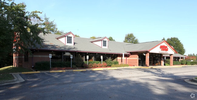
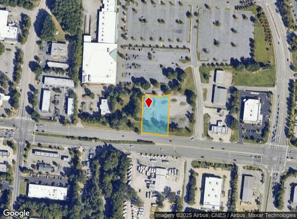
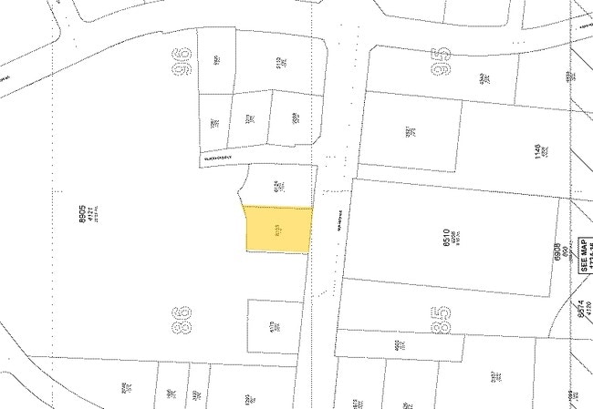
Property Record
4201 New Bern Ave, Raleigh, NC 27610
NEARBY LISTINGS FOR SALE OR LEASE
Property Detail
4201 New Bern Ave
Raleigh, NC
Wilders Grove I
1724.12-86-8153-000
LO3 WILDERS GROVE INC BM1992-1298
Agriculturalland
Wake
X
North Carolina
3720172400K
3
2025
0.99 AC
2025
Northeast Wake County
052707
Raleigh/Durham
9,594 SF
DEMOGRAPHICS near 4201 New Bern Ave
1 Mile
3 Mile
5 Mile
2024 Total Population
7,433
68,714
205,589
2029 Population
8,100
74,476
223,905
Pop Growth 2024-2029
+ 8.97%
+ 8.39%
+ 8.91%
Average Age
38
38
37
2024 Total Households
2,680
26,479
82,622
HH Growth 2024-2029
+ 8.99%
+ 8.49%
+ 9.17%
Median Household Inc
$77,944
$69,721
$69,579
Avg Household Size
2.70
2.50
2.40
2024 Avg HH Vehicles
2.00
2.00
2.00
Median Home Value
$214,409
$234,226
$272,335
Median Year Built
1996
1993
1994
Nearby Places
- Restaurants
- Banks
- Shops
- Fitness
- Groceries
PUBLIC TRANSPORTATION
COMMUTER RAIL
Raleigh Union Station (Piedmont - North Carolina by Train (NC Train))
DRIVE
WALK
Distance
Raleigh Union Station (Piedmont - North Carolina by Train (NC Train))
12 min
5.7 mi
AIRPORT
Raleigh-Durham International
DRIVE
WALK
Distance
Raleigh-Durham International
29 min
16.9 mi
Nearby Properties
Address
Land Use
TOTAL SIZE
Lot Size
Zoning
Address
Land Use
TOTAL SIZE
Lot Size
Zoning
2,660,245 SF
38.98 AC
CMP
Address
Land Use
TOTAL SIZE
Lot Size
Zoning
701,923 SF
64.64 AC
RX-5
Address
Land Use
TOTAL SIZE
Lot Size
Zoning
354,131 SF
15.23 AC
RX-4
Address
Land Use
TOTAL SIZE
Lot Size
Zoning
289,301 SF
20.67 AC
OX-12
Address
Land Use
TOTAL SIZE
Lot Size
Zoning
319,136 SF
22.25 AC
OX-12
Address
Land Use
TOTAL SIZE
Lot Size
Zoning
438,469 SF
50 AC
R-4
Address
Land Use
TOTAL SIZE
Lot Size
Zoning
507,000 SF
46.54 AC
MI PU
Address
Land Use
TOTAL SIZE
Lot Size
Zoning
211,289 SF
6.87 AC
CX-5
Address
Land Use
TOTAL SIZE
Lot Size
Zoning
433,221 SF
7.78 AC
CMP
Address
Land Use
TOTAL SIZE
Lot Size
Zoning
320,135 SF
17.75 AC
NMX
Address
Land Use
TOTAL SIZE
Lot Size
Zoning
313,755 SF
22.44 AC
PD
Address
Land Use
TOTAL SIZE
Lot Size
Zoning
261,096 SF
17.30 AC
NMX
Address
Land Use
TOTAL SIZE
Lot Size
Zoning
2,916 SF
81 AC
R-6
Address
Land Use
TOTAL SIZE
Lot Size
Zoning
535,591 SF
32.35 AC
IX-3
Address
Land Use
TOTAL SIZE
Lot Size
Zoning
202,055 SF
15.11 AC
RX-4
Address
Land Use
TOTAL SIZE
Lot Size
Zoning
194,832 SF
11.06 AC
RX-3
Address
Land Use
TOTAL SIZE
Lot Size
Zoning
175,250 SF
1.74 AC
OX-5
Address
Land Use
TOTAL SIZE
Lot Size
Zoning
202,980 SF
16.96 AC
RX-3
Address
Land Use
TOTAL SIZE
Lot Size
Zoning
296,209 SF
19.08 AC
IX-3
Address
Land Use
TOTAL SIZE
Lot Size
Zoning
38,341 SF
259.59 AC
IH
Address
Land Use
TOTAL SIZE
Lot Size
Zoning
95,252 SF
19.04 AC
IX-3
Address
Land Use
TOTAL SIZE
Lot Size
Zoning
196,732 SF
12.02 AC
RX-3
Address
Land Use
TOTAL SIZE
Lot Size
Zoning
94,876 SF
42.83 AC
OX-3
Address
Land Use
TOTAL SIZE
Lot Size
Zoning
180,000 SF
24.61 AC
MI CD
Address
Land Use
TOTAL SIZE
Lot Size
Zoning
296,313 SF
5.76 AC
OP-12
Address
Land Use
TOTAL SIZE
Lot Size
Zoning
99,834 SF
21 AC
AP
Address
Land Use
TOTAL SIZE
Lot Size
Zoning
349,950 SF
7.59 AC
OP-12
Address
Land Use
TOTAL SIZE
Lot Size
Zoning
84,446 SF
22.87 AC
IX-3
Address
Land Use
TOTAL SIZE
Lot Size
Zoning
203,777 SF
12.37 AC
RX-3
Address
Land Use
TOTAL SIZE
Lot Size
Zoning
96,023 SF
18.79 AC
MI
The World's #1 Commercial Real Estate Marketplace
Connect with us
© 2025 CoStar Group
The information above has been obtained from sources believed reliable. While we do not doubt its accuracy we have not verified it and make no guarantee, warranty or representation about it. It is your responsibility to independently confirm its accuracy and completeness. Any projections, opinions, assumptions, or estimates used are for example only and do not represent the current or future performance of the property. The value of this transaction to you depends on tax and other factors which should be evaluated by your tax, financial, and legal advisors. You and your advisors should conduct a careful, independent investigation of the property to determine to your satisfaction the suitability of the property for your needs.