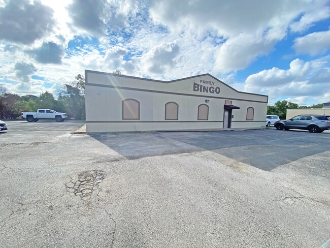
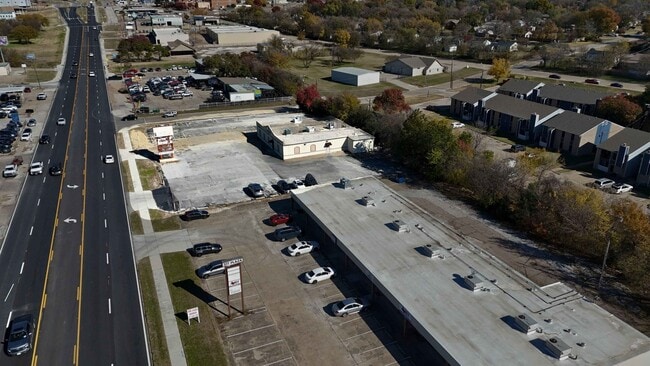
Property Record
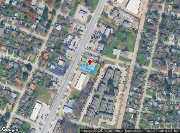
4201 Benbrook Hwy, Fort Worth, TX 76116
Current Lease Availabilities
NEARBY LISTINGS FOR SALE OR LEASE
Property Detail
4201 Benbrook Hwy
Dallas-Fort Worth-Arlington, TX
Ridgecrest Addition-Fort Worth
02387476
RIDGECREST ADDITION-FORT WORTH BLOCK 23 LOT 14 & N25 15
Commercialnec
Tarrant
A
Texas
48439C0280K
14
2024
0.60 AC
2025
West Southwest Ft Worth
102301
Dallas/Ft Worth
5,125 SF
DEMOGRAPHICS near 4201 Benbrook Hwy
1 Mile
3 Mile
5 Mile
2024 Total Population
11,356
87,880
209,162
2029 Population
11,911
93,213
221,430
Pop Growth 2024-2029
+ 4.89%
+ 6.07%
+ 5.87%
Average Age
38
38
38
2024 Total Households
4,295
38,764
88,063
HH Growth 2024-2029
+ 4.91%
+ 6.21%
+ 6.06%
Median Household Inc
$62,201
$55,989
$63,613
Avg Household Size
2.60
2.20
2.30
2024 Avg HH Vehicles
2.00
2.00
2.00
Median Home Value
$247,686
$287,335
$288,790
Median Year Built
1959
1981
1982
Nearby Places
Map Layers
Map Styles
 Street
 Aerial
- Restaurants
- Banks
- Shops
- Fitness
- Groceries
PUBLIC TRANSPORTATION
COMMUTER RAIL
Texas And Pacific (T&P) (Trinity Railway Express - Dallas Area Rapid Transit (DART))
DRIVE
WALK
Distance
Texas And Pacific (T&P) (Trinity Railway Express - Dallas Area Rapid Transit (DART))
14 min
8.2 mi
Fort Worth (Heartland Flyer - Amtrak, Texas Eagle - Amtrak)
DRIVE
WALK
Distance
Fort Worth (Heartland Flyer - Amtrak, Texas Eagle - Amtrak)
14 min
8.5 mi
AIRPORT
Dallas-Fort Worth International
DRIVE
WALK
Distance
Dallas-Fort Worth International
44 min
33.0 mi
Freight Ports
Port of Shreveport
DRIVE
WALK
Distance
Port of Shreveport
253 min
236.0 mi
Nearby Properties
Address
Land Use
TOTAL SIZE
Lot Size
Zoning
Address
Land Use
TOTAL SIZE
Lot Size
Zoning
505,069 SF
6.49 AC
Address
Land Use
TOTAL SIZE
Lot Size
Zoning
438,943 SF
3.77 AC
Address
Land Use
TOTAL SIZE
Lot Size
Zoning
477,907 SF
11.83 AC
Address
Land Use
TOTAL SIZE
Lot Size
Zoning
346,920 SF
9.88 AC
Address
Land Use
TOTAL SIZE
Lot Size
Zoning
492,130 SF
6.55 AC
Address
Land Use
TOTAL SIZE
Lot Size
Zoning
364,647 SF
17.90 AC
Address
Land Use
TOTAL SIZE
Lot Size
Zoning
355,125 SF
21.29 AC
Address
Land Use
TOTAL SIZE
Lot Size
Zoning
350,654 SF
21.29 AC
Address
Land Use
TOTAL SIZE
Lot Size
Zoning
296,664 SF
14.71 AC
Address
Land Use
TOTAL SIZE
Lot Size
Zoning
347,423 SF
7.32 AC
Address
Land Use
TOTAL SIZE
Lot Size
Zoning
100,000 SF
1.60 AC
Address
Land Use
TOTAL SIZE
Lot Size
Zoning
242,244 SF
27.01 AC
Address
Land Use
TOTAL SIZE
Lot Size
Zoning
312,709 SF
16.26 AC
Address
Land Use
TOTAL SIZE
Lot Size
Zoning
244,918 SF
15.52 AC
Address
Land Use
TOTAL SIZE
Lot Size
Zoning
292,450 SF
8.17 AC
Address
Land Use
TOTAL SIZE
Lot Size
Zoning
267,098 SF
14.06 AC
Address
Land Use
TOTAL SIZE
Lot Size
Zoning
166,474 SF
12.60 AC
Address
Land Use
TOTAL SIZE
Lot Size
Zoning
209,329 SF
90.74 AC
Address
Land Use
TOTAL SIZE
Lot Size
Zoning
372,523 SF
3.46 AC
Address
Land Use
TOTAL SIZE
Lot Size
Zoning
271,065 SF
9.03 AC
Address
Land Use
TOTAL SIZE
Lot Size
Zoning
252,703 SF
14.35 AC
Address
Land Use
TOTAL SIZE
Lot Size
Zoning
179,980 SF
2.67 AC
Address
Land Use
TOTAL SIZE
Lot Size
Zoning
172,520 SF
2.37 AC
Address
Land Use
TOTAL SIZE
Lot Size
Zoning
152,640 SF
15.91 AC
Address
Land Use
TOTAL SIZE
Lot Size
Zoning
309,655 SF
23.99 AC
Address
Land Use
TOTAL SIZE
Lot Size
Zoning
228,609 SF
9.86 AC
Address
Land Use
TOTAL SIZE
Lot Size
Zoning
189,598 SF
8.91 AC
Address
Land Use
TOTAL SIZE
Lot Size
Zoning
226,619 SF
19.15 AC
Address
Land Use
TOTAL SIZE
Lot Size
Zoning
215,548 SF
7.79 AC
Address
Land Use
TOTAL SIZE
Lot Size
Zoning
357,676 SF
9.03 AC
The World's #1 Commercial Real Estate Marketplace
Connect with us
© 2025 CoStar Group
The information above has been obtained from sources believed reliable. While we do not doubt its accuracy we have not verified it and make no guarantee, warranty or representation about it. It is your responsibility to independently confirm its accuracy and completeness. Any projections, opinions, assumptions, or estimates used are for example only and do not represent the current or future performance of the property. The value of this transaction to you depends on tax and other factors which should be evaluated by your tax, financial, and legal advisors. You and your advisors should conduct a careful, independent investigation of the property to determine to your satisfaction the suitability of the property for your needs.