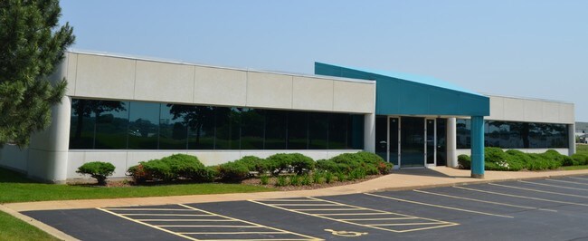
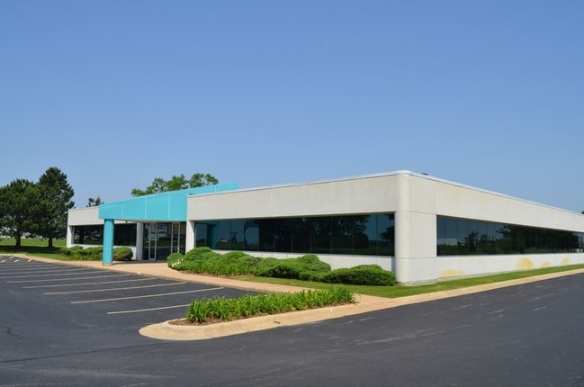
Property Record
4201 Galleria Dr, Loves Park, IL 61111

NEARBY LISTINGS FOR SALE OR LEASE
Property Detail
4201 Galleria Dr
Rockford, IL
S Park
12-02-178-002
ROCK CUT BUSINESS PARK BNG PT NW 1/4 SEC 2-44-2 16 FT LYG E & ADJ LT 4 & ALLLOT 4
Officebuilding
Winnebago
X
Illinois
17201C0278E
4
2024
1 AC
2024
I-39 Corr/Winnebago Cnty
003810
Chicago
19,200 SF
DEMOGRAPHICS near 4201 Galleria Dr
1 Mile
3 Mile
5 Mile
2024 Total Population
4,501
31,982
94,159
2029 Population
4,431
31,509
92,877
Pop Growth 2024-2029
(1.56%)
(1.48%)
(1.36%)
Average Age
43
44
43
2024 Total Households
2,022
13,572
39,016
HH Growth 2024-2029
(1.63%)
(1.48%)
(1.37%)
Median Household Inc
$75,658
$79,868
$69,800
Avg Household Size
2.20
2.30
2.30
2024 Avg HH Vehicles
2.00
2.00
2.00
Median Home Value
$179,716
$183,400
$165,035
Median Year Built
1998
1990
1979
Nearby Places
Map Layers
Map Styles
 Street
 Aerial
- Restaurants
- Banks
- Shops
- Fitness
- Groceries
PUBLIC TRANSPORTATION
AIRPORT
Chicago/Rockford International
DRIVE
WALK
Distance
Chicago/Rockford International
28 min
17.6 mi
SALE & LEASE HISTORY
LISTING DATE
SALE/LEASE

Nov 07, 2017
For Lease
Jan 17, 2017
For Sale
Aug 24, 2017
For Lease
Aug 24, 2017
For Sale
Nearby Properties
Address
Land Use
TOTAL SIZE
Lot Size
Zoning
Address
Land Use
TOTAL SIZE
Lot Size
Zoning
189,000 SF
56.75 AC
IL - INDUS
Address
Land Use
TOTAL SIZE
Lot Size
Zoning
Address
Land Use
TOTAL SIZE
Lot Size
Zoning
Address
Land Use
TOTAL SIZE
Lot Size
Zoning
Address
Land Use
TOTAL SIZE
Lot Size
Zoning
69,864 SF
9.39 AC
C3
Address
Land Use
TOTAL SIZE
Lot Size
Zoning
195,672 SF
10.63 AC
C3
Address
Land Use
TOTAL SIZE
Lot Size
Zoning
213,659 SF
18 AC
IL
Address
Land Use
TOTAL SIZE
Lot Size
Zoning
10.01 AC
Address
Land Use
TOTAL SIZE
Lot Size
Zoning
114,176 SF
4.94 AC
R4
Address
Land Use
TOTAL SIZE
Lot Size
Zoning
151,523 SF
16.05 AC
CR
Address
Land Use
TOTAL SIZE
Lot Size
Zoning
65,541 SF
24.36 AC
C3
Address
Land Use
TOTAL SIZE
Lot Size
Zoning
67,360 SF
5.91 AC
C2
Address
Land Use
TOTAL SIZE
Lot Size
Zoning
63,492 SF
4.92 AC
C1
Address
Land Use
TOTAL SIZE
Lot Size
Zoning
81,248 SF
10.20 AC
Address
Land Use
TOTAL SIZE
Lot Size
Zoning
79,147 SF
5.08 AC
R3
Address
Land Use
TOTAL SIZE
Lot Size
Zoning
210,007 SF
15.86 AC
C2
Address
Land Use
TOTAL SIZE
Lot Size
Zoning
Address
Land Use
TOTAL SIZE
Lot Size
Zoning
31,080 SF
2.53 AC
C2
Address
Land Use
TOTAL SIZE
Lot Size
Zoning
46,750 SF
9.11 AC
Address
Land Use
TOTAL SIZE
Lot Size
Zoning
62.32 AC
C3
Address
Land Use
TOTAL SIZE
Lot Size
Zoning
44,989 SF
4.51 AC
C2
Address
Land Use
TOTAL SIZE
Lot Size
Zoning
72,149 SF
1.12 AC
C1
Address
Land Use
TOTAL SIZE
Lot Size
Zoning
85,500 SF
9.10 AC
C1
Address
Land Use
TOTAL SIZE
Lot Size
Zoning
136,775 SF
24.28 AC
IL_CR
Address
Land Use
TOTAL SIZE
Lot Size
Zoning
82,582 SF
7.92 AC
CR
Address
Land Use
TOTAL SIZE
Lot Size
Zoning
55,928 SF
7.86 AC
IL_CR
Address
Land Use
TOTAL SIZE
Lot Size
Zoning
52,560 SF
5.21 AC
C1
Address
Land Use
TOTAL SIZE
Lot Size
Zoning
50,608 SF
7.99 AC
Address
Land Use
TOTAL SIZE
Lot Size
Zoning
31,547 SF
10.40 AC
R3
Address
Land Use
TOTAL SIZE
Lot Size
Zoning
The World's #1 Commercial Real Estate Marketplace
Connect with us
© 2026 CoStar Group
The information above has been obtained from sources believed reliable. While we do not doubt its accuracy we have not verified it and make no guarantee, warranty or representation about it. It is your responsibility to independently confirm its accuracy and completeness. Any projections, opinions, assumptions, or estimates used are for example only and do not represent the current or future performance of the property. The value of this transaction to you depends on tax and other factors which should be evaluated by your tax, financial, and legal advisors. You and your advisors should conduct a careful, independent investigation of the property to determine to your satisfaction the suitability of the property for your needs.