Property Record
Garcon Point Rd, Milton, FL 32583
Save to a Folder
{{folder.Name}}
{{folder.ListingIds.length}} Properties
{{folder.ListingIds.length}} Property
Create a New Folder
Property Detail
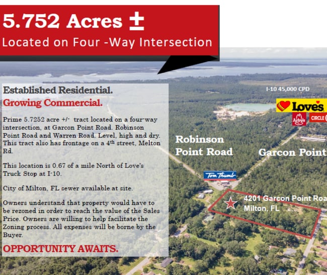
Garcon Point Rd
Pensacola-Ferry Pass-Brent, FL
*DESCRIPTION UPDATE FOR 2025* SMITHVILLE SUBD PARCEL B: THE W 168.30 FT OF THE FOLLWG: LOTS 3 4 & 5 BLK 4 (DB R PG 148 SUBJ TO A MAINT CLM LTS OF WARREN RD & SUBJ TO THE R/W LMTS OF MELTON RD (30 R/W). AS DES IN OR 4596 PG 1105
15-1N-28-5120-00400-0031
SANTA ROSA
Vacantlandnec
Florida
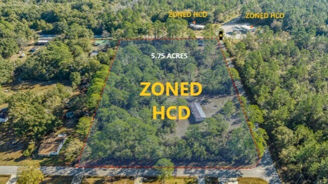
HCD
31
AE The base floodplain where base flood elevations are provided. AE Zones are now used on new format FIRMs instead of A1-A30 Zones.
1.43 AC
2024
Avalon Beach/Milton
2025
Pensacola
010709
NEARBY LISTINGS FOR SALE OR LEASE
DEMOGRAPHICS near Garcon Point Rd
1 mile
3 mile
5 mile
2025 Total Population
2,556
13,017
44,689
2030 Population
2,798
14,208
48,530
Pop Growth 2025-2030
+ 9.47%
+ 9.15%
+ 8.59%
Average Age
42
41
41
2025 Total Households
984
5,086
16,630
HH Growth 2025-2030
+ 9.25%
+ 8.99%
+ 8.56%
Median Household Inc
$84,523
$78,625
$77,449
Avg Household Size
2.50
2.50
2.50
2025 Avg HH Vehicles
2.00
2.00
2.00
Median Home Value
$261,506
$246,448
$265,676
Median Year Built
2002
1992
1992
Nearby Places
Map Layers
Map Styles
 Street
 Aerial
Layers
 Traffic
 Biking
Places
Listings with unknown addresses are not visible on the map
- Restaurants
- Banks
- Shops
- Fitness
- Groceries
PUBLIC TRANSPORTATION
AIRPORT
Pensacola International
Drive
Walk
Distance
Pensacola International
28 min
17.7 mi
Freight Ports
Port of Mobile
Drive
Walk
Distance
Port of Mobile
77 min
67.8 mi
SALE & LEASE HISTORY
LISTING DATE
SALE/LEASE

Nov 07, 2025
For Sale
Jul 19, 2022
For Sale
Jan 07, 2024
For Sale
Nearby Properties
Address
Land Use
TOTAL SIZE
Lot Size
Zoning
Address
Land Use
TOTAL SIZE
Lot Size
Zoning
113,178 SF
8.61 AC
HCD
Address
Land Use
TOTAL SIZE
Lot Size
Zoning
151,842 SF
14.28 AC
C2
Address
Land Use
TOTAL SIZE
Lot Size
Zoning
113,652 SF
9.52 AC
C2
Address
Land Use
TOTAL SIZE
Lot Size
Zoning
82,878 SF
9.07 AC
HCD
Address
Land Use
TOTAL SIZE
Lot Size
Zoning
76.81 AC
R1
Address
Land Use
TOTAL SIZE
Lot Size
Zoning
98,250 SF
49.63 AC
HCD
Address
Land Use
TOTAL SIZE
Lot Size
Zoning
68,026 SF
2.07 AC
RC1
Address
Land Use
TOTAL SIZE
Lot Size
Zoning
48,210 SF
8.98 AC
C2
Address
Land Use
TOTAL SIZE
Lot Size
Zoning
16,903 SF
11 AC
AG-RR
Address
Land Use
TOTAL SIZE
Lot Size
Zoning
37,820 SF
16.98 AC
HCD
Address
Land Use
TOTAL SIZE
Lot Size
Zoning
41,105 SF
8.16 AC
HCD
Address
Land Use
TOTAL SIZE
Lot Size
Zoning
43,312 SF
15 AC
HCD
Address
Land Use
TOTAL SIZE
Lot Size
Zoning
60,717 SF
4.43 AC
HCD
Address
Land Use
TOTAL SIZE
Lot Size
Zoning
26,200 SF
7.74 AC
HCD
Address
Land Use
TOTAL SIZE
Lot Size
Zoning
77,589 SF
9.39 AC
HCD
Address
Land Use
TOTAL SIZE
Lot Size
Zoning
24,801 SF
2.32 AC
C2
Address
Land Use
TOTAL SIZE
Lot Size
Zoning
25,264 SF
3.72 AC
C2
Address
Land Use
TOTAL SIZE
Lot Size
Zoning
4.33 AC
HR1
Address
Land Use
TOTAL SIZE
Lot Size
Zoning
34,555 SF
6.05 AC
R3
Address
Land Use
TOTAL SIZE
Lot Size
Zoning
35,503 SF
5.45 AC
PUD
Address
Land Use
TOTAL SIZE
Lot Size
Zoning
38,797 SF
2.81 AC
R2
Address
Land Use
TOTAL SIZE
Lot Size
Zoning
9,058 SF
8.35 AC
I1
Address
Land Use
TOTAL SIZE
Lot Size
Zoning
42,160 SF
7.90 AC
HCD
Address
Land Use
TOTAL SIZE
Lot Size
Zoning
55,416 SF
4.96 AC
C2
Address
Land Use
TOTAL SIZE
Lot Size
Zoning
16,009 SF
8.69 AC
HCD
Address
Land Use
TOTAL SIZE
Lot Size
Zoning
34,226 SF
2.85 AC
R3
Address
Land Use
TOTAL SIZE
Lot Size
Zoning
10,401 SF
11.79 AC
HCD
Address
Land Use
TOTAL SIZE
Lot Size
Zoning
44,028 SF
8.73 AC
C2
Address
Land Use
TOTAL SIZE
Lot Size
Zoning
48,158 SF
4.72 AC
HCD
The World's #1 Commercial Real Estate Marketplace
Connect with us
© 2026 CoStar Group
The information above has been obtained from sources believed reliable. While we do not doubt its accuracy we have not verified it and make no guarantee, warranty or representation about it. It is your responsibility to independently confirm its accuracy and completeness. Any projections, opinions, assumptions, or estimates used are for example only and do not represent the current or future performance of the property. The value of this transaction to you depends on tax and other factors which should be evaluated by your tax, financial, and legal advisors. You and your advisors should conduct a careful, independent investigation of the property to determine to your satisfaction the suitability of the property for your needs.