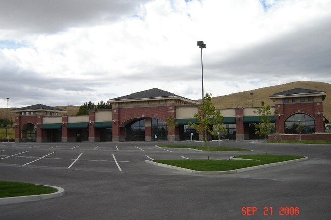
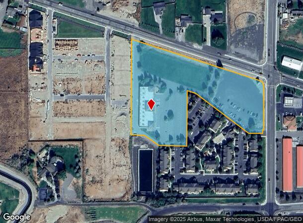
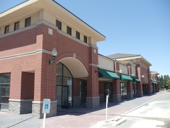
Property Record
4201 Kennedy Rd, West Richland, WA 99353
NEARBY LISTINGS FOR SALE OR LEASE
Property Detail
4201 Kennedy Rd
Other Market Areas
Short Plat #2789
Kennewick-Richland, WA
THAT PORTION OF LOT 1, SHORT PLAT #2789, AF#2004-004515 IN SECTION 17, TOWNSHIP 9 NORTH, RANGE 28 EAST, W.M. BENTON COUNTY, WASHINGTON, BEING MORE PARTICULARLY DESCRIBED AS FOLLOWS; COMMENCING AT THE SOUTHWEST CORNER OF SAID LOT 1, SHORT PLAT #2789;
117983012789006
Benton
Storebuilding
Washington
2024
1
2024
5.92 AC
010807
Yakima/Kennewick
15,496 SF
DEMOGRAPHICS near 4201 Kennedy Rd
1 Mile
3 Mile
5 Mile
2024 Total Population
4,250
31,136
78,514
2029 Population
4,555
33,468
84,492
Pop Growth 2024-2029
+ 7.18%
+ 7.49%
+ 7.61%
Average Age
37
38
39
2024 Total Households
1,380
11,352
29,445
HH Growth 2024-2029
+ 7.17%
+ 7.42%
+ 7.63%
Median Household Inc
$143,227
$116,217
$99,902
Avg Household Size
3.00
2.70
2.60
2024 Avg HH Vehicles
3.00
2.00
2.00
Median Home Value
$470,641
$386,248
$384,959
Median Year Built
2002
1999
1993
Nearby Places
Map Layers
Map Styles
 Street
 Aerial
- Restaurants
- Banks
- Shops
- Fitness
- Groceries
PUBLIC TRANSPORTATION
AIRPORT
Tri-Cities
DRIVE
WALK
Distance
Tri-Cities
21 min
13.1 mi
SALE & LEASE HISTORY
LISTING DATE
SALE/LEASE

Sep 25, 2016
For Lease
Aug 01, 2018
For Lease
Nearby Properties
Address
Land Use
TOTAL SIZE
Lot Size
Zoning
Address
Land Use
TOTAL SIZE
Lot Size
Zoning
143,592 SF
6.86 AC
RICHLAND -
Address
Land Use
TOTAL SIZE
Lot Size
Zoning
236,556 SF
11.34 AC
Address
Land Use
TOTAL SIZE
Lot Size
Zoning
185,302 SF
9.13 AC
Address
Land Use
TOTAL SIZE
Lot Size
Zoning
118,956 SF
30.48 AC
Address
Land Use
TOTAL SIZE
Lot Size
Zoning
82,226 SF
40 AC
G.M.A. AGR
Address
Land Use
TOTAL SIZE
Lot Size
Zoning
216,270 SF
22.32 AC
Address
Land Use
TOTAL SIZE
Lot Size
Zoning
113,052 SF
3.32 AC
Address
Land Use
TOTAL SIZE
Lot Size
Zoning
170,307 SF
14.15 AC
Address
Land Use
TOTAL SIZE
Lot Size
Zoning
109,517 SF
4.67 AC
Address
Land Use
TOTAL SIZE
Lot Size
Zoning
102,146 SF
40 AC
Address
Land Use
TOTAL SIZE
Lot Size
Zoning
126,251 SF
7 AC
Address
Land Use
TOTAL SIZE
Lot Size
Zoning
76,249 SF
13 AC
Address
Land Use
TOTAL SIZE
Lot Size
Zoning
42,782 SF
72.06 AC
Address
Land Use
TOTAL SIZE
Lot Size
Zoning
127,195 SF
9.16 AC
Address
Land Use
TOTAL SIZE
Lot Size
Zoning
74,352 SF
13.55 AC
RICHLAND -
Address
Land Use
TOTAL SIZE
Lot Size
Zoning
66,380 SF
2.98 AC
Address
Land Use
TOTAL SIZE
Lot Size
Zoning
62,733 SF
14.60 AC
Address
Land Use
TOTAL SIZE
Lot Size
Zoning
74,028 SF
6.02 AC
Address
Land Use
TOTAL SIZE
Lot Size
Zoning
65,207 SF
19.35 AC
RICHLAND -
Address
Land Use
TOTAL SIZE
Lot Size
Zoning
102,189 SF
12.57 AC
Address
Land Use
TOTAL SIZE
Lot Size
Zoning
56,700 SF
6.47 AC
Address
Land Use
TOTAL SIZE
Lot Size
Zoning
71,700 SF
9.33 AC
Address
Land Use
TOTAL SIZE
Lot Size
Zoning
49,048 SF
6.45 AC
Address
Land Use
TOTAL SIZE
Lot Size
Zoning
59,102 SF
5.39 AC
WEST RICHL
Address
Land Use
TOTAL SIZE
Lot Size
Zoning
28,865 SF
8.42 AC
Address
Land Use
TOTAL SIZE
Lot Size
Zoning
11,625 SF
29.71 AC
Address
Land Use
TOTAL SIZE
Lot Size
Zoning
113,464 SF
27.38 AC
Address
Land Use
TOTAL SIZE
Lot Size
Zoning
56,902 SF
3.69 AC
Address
Land Use
TOTAL SIZE
Lot Size
Zoning
24,000 SF
5.45 AC
Address
Land Use
TOTAL SIZE
Lot Size
Zoning
23,347 SF
5 AC
The World's #1 Commercial Real Estate Marketplace
Connect with us
© 2026 CoStar Group
The information above has been obtained from sources believed reliable. While we do not doubt its accuracy we have not verified it and make no guarantee, warranty or representation about it. It is your responsibility to independently confirm its accuracy and completeness. Any projections, opinions, assumptions, or estimates used are for example only and do not represent the current or future performance of the property. The value of this transaction to you depends on tax and other factors which should be evaluated by your tax, financial, and legal advisors. You and your advisors should conduct a careful, independent investigation of the property to determine to your satisfaction the suitability of the property for your needs.