Property Record
4201 Nowata Rd, Bartlesville, OK 74006


Save to a Folder
{{folder.Name}}
{{folder.ListingIds.length}} Properties
{{folder.ListingIds.length}} Property
Create a New Folder
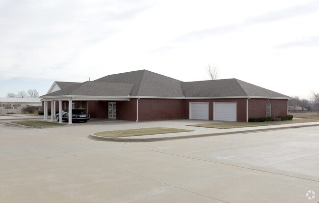
Property Detail
4201 Nowata Rd
0051753
PART SECT 21-26-13 BEG AT NE COR OF W 1/2 NE NW FOR POB: S 0 DEG 21 MIN E 310'; S 89 DEG 57 MIN W 299.22' N 0 DEG 21 MIN W 31
Crematorium
Washington
AA1
Oklahoma
B and X Area of moderate flood hazard, usually the area between the limits of the 100-year and 500-year floods.
613
2025
2.13 AC
2025
Bartlesville
000602
Tulsa
6,696 SF
Bartlesville, OK
NEARBY LISTINGS FOR SALE OR LEASE
DEMOGRAPHICS near 4201 Nowata Rd
1 mile
3 mile
5 mile
2025 Total Population
7,281
32,101
42,753
2030 Population
7,470
32,883
43,936
Pop Growth 2025-2030
+ 2.60%
+ 2.44%
+ 2.77%
Average Age
42
41
41
2025 Total Households
2,904
13,162
17,426
HH Growth 2025-2030
+ 2.55%
+ 2.42%
+ 2.76%
Median Household Inc
$77,278
$64,785
$58,787
Avg Household Size
2.40
2.30
2.30
2025 Avg HH Vehicles
2.00
2.00
2.00
Median Home Value
$195,832
$188,162
$176,333
Median Year Built
1974
1972
1969
Nearby Places
Map Layers
Map Styles
 Street
 Aerial
Layers
 Traffic
 Biking
Places
Listings with unknown addresses are not visible on the map
- Restaurants
- Banks
- Shops
- Fitness
- Groceries
Nearby Properties
Address
Land Use
TOTAL SIZE
Lot Size
Zoning
Address
Land Use
TOTAL SIZE
Lot Size
Zoning
40,965 SF
66.92 AC
AA1
Address
Land Use
TOTAL SIZE
Lot Size
Zoning
22,593 SF
9 AC
AA1
Address
Land Use
TOTAL SIZE
Lot Size
Zoning
13,977 SF
1.38 AC
AA1
Address
Land Use
TOTAL SIZE
Lot Size
Zoning
60,500 SF
6.72 AC
AA1
Address
Land Use
TOTAL SIZE
Lot Size
Zoning
21,230 SF
2.69 AC
AA1
Address
Land Use
TOTAL SIZE
Lot Size
Zoning
25,003 SF
4.11 AC
AA1
Address
Land Use
TOTAL SIZE
Lot Size
Zoning
37,400 SF
2.81 AC
AA1
Address
Land Use
TOTAL SIZE
Lot Size
Zoning
24,161 SF
3.34 AC
AA1
Address
Land Use
TOTAL SIZE
Lot Size
Zoning
40,770 SF
2.07 AC
AA1
Address
Land Use
TOTAL SIZE
Lot Size
Zoning
41,650 SF
8.84 AC
Address
Land Use
TOTAL SIZE
Lot Size
Zoning
90,510 SF
9.41 AC
Address
Land Use
TOTAL SIZE
Lot Size
Zoning
3,798 SF
3.17 AC
AA1
Address
Land Use
TOTAL SIZE
Lot Size
Zoning
195,856 SF
15.63 AC
AA1
Address
Land Use
TOTAL SIZE
Lot Size
Zoning
4,704 SF
3.44 AC
AA1
Address
Land Use
TOTAL SIZE
Lot Size
Zoning
14,720 SF
7.30 AC
Address
Land Use
TOTAL SIZE
Lot Size
Zoning
94,863 SF
3.93 AC
AA1
Address
Land Use
TOTAL SIZE
Lot Size
Zoning
42,368 SF
24.47 AC
AA1
Address
Land Use
TOTAL SIZE
Lot Size
Zoning
16,776 SF
10.30 AC
AA1
Address
Land Use
TOTAL SIZE
Lot Size
Zoning
92,512 SF
8.25 AC
AA1
Address
Land Use
TOTAL SIZE
Lot Size
Zoning
118,524 SF
13.97 AC
AA1
Address
Land Use
TOTAL SIZE
Lot Size
Zoning
903 SF
0.96 AC
AA1
Address
Land Use
TOTAL SIZE
Lot Size
Zoning
53,008 SF
1.82 AC
AA1
Address
Land Use
TOTAL SIZE
Lot Size
Zoning
6,592 SF
1.10 AC
AA1
Address
Land Use
TOTAL SIZE
Lot Size
Zoning
7,020 SF
2.32 AC
Address
Land Use
TOTAL SIZE
Lot Size
Zoning
17,800 SF
4.57 AC
Address
Land Use
TOTAL SIZE
Lot Size
Zoning
16,062 SF
1.54 AC
AA1
Address
Land Use
TOTAL SIZE
Lot Size
Zoning
41,400 SF
13.39 AC
AA1
Address
Land Use
TOTAL SIZE
Lot Size
Zoning
51,836 SF
1.64 AC
AA1
Address
Land Use
TOTAL SIZE
Lot Size
Zoning
33,550 SF
4.88 AC
AA1
Address
Land Use
TOTAL SIZE
Lot Size
Zoning
67,849 SF
6.88 AC
AA1
The World's #1 Commercial Real Estate Marketplace
Connect with us
© 2026 CoStar Group
The information above has been obtained from sources believed reliable. While we do not doubt its accuracy we have not verified it and make no guarantee, warranty or representation about it. It is your responsibility to independently confirm its accuracy and completeness. Any projections, opinions, assumptions, or estimates used are for example only and do not represent the current or future performance of the property. The value of this transaction to you depends on tax and other factors which should be evaluated by your tax, financial, and legal advisors. You and your advisors should conduct a careful, independent investigation of the property to determine to your satisfaction the suitability of the property for your needs.