Property Record
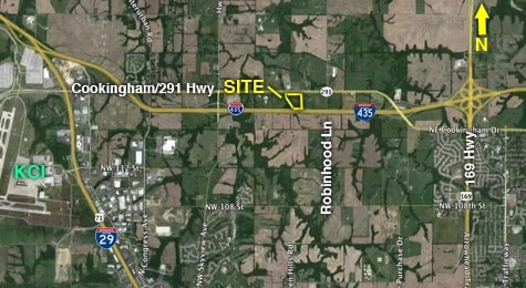
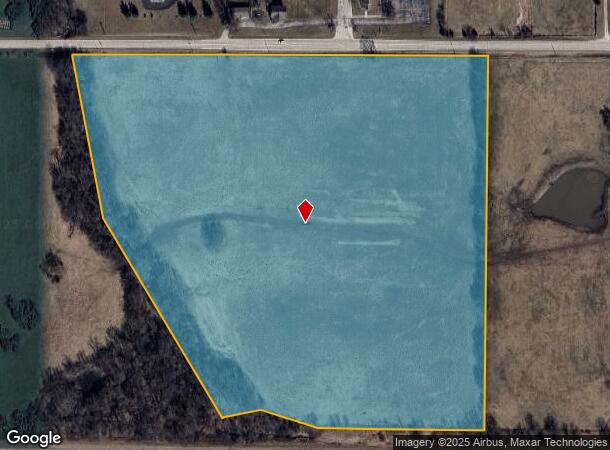
4201 Nw Cookingham Dr, Kansas City, MO 64164
NEARBY LISTINGS FOR SALE OR LEASE
Property Detail
4201 Nw Cookingham Dr
18-40-20-000-000-001-003
BEG NW CORNER OF SEC 20 T52 R33 THEN E 800 THEN S 1175 THEN W ALONG ROW 785 THEN N 30 W 715 THEN N 15 W 515 THEN E TO POB
Agriculturalland
Platte
A
Missouri
29095C0042G
27.76 AC
2024
I-29 Corridor
2025
Kansas City
0306006094
Kansas City, MO-KS
DEMOGRAPHICS near 4201 Nw Cookingham Dr
1 Mile
3 Mile
5 Mile
2024 Total Population
72
7,727
57,461
2029 Population
78
8,387
61,865
Pop Growth 2024-2029
+ 8.33%
+ 8.54%
+ 7.66%
Average Age
42
38
38
2024 Total Households
27
2,968
23,296
HH Growth 2024-2029
+ 7.41%
+ 9.13%
+ 7.93%
Median Household Inc
$84,375
$88,662
$81,095
Avg Household Size
2.60
2.50
2.40
2024 Avg HH Vehicles
2.00
2.00
2.00
Median Home Value
$337,500
$262,685
$266,025
Median Year Built
1996
2003
1996
Nearby Places
Map Layers
Map Styles
 Street
 Aerial
- Restaurants
- Banks
- Shops
- Fitness
- Groceries
PUBLIC TRANSPORTATION
AIRPORT
Kansas City International
DRIVE
WALK
Distance
Kansas City International
9 min
5.4 mi
Freight Ports
Tulsa Port Of Catoosa
DRIVE
WALK
Distance
Tulsa Port Of Catoosa
287 min
254.6 mi
SALE & LEASE HISTORY
LISTING DATE
SALE/LEASE

Apr 12, 2017
For Sale
Nearby Properties
Address
Land Use
TOTAL SIZE
Lot Size
Zoning
Address
Land Use
TOTAL SIZE
Lot Size
Zoning
Address
Land Use
TOTAL SIZE
Lot Size
Zoning
421,339 SF
16.91 AC
Address
Land Use
TOTAL SIZE
Lot Size
Zoning
Address
Land Use
TOTAL SIZE
Lot Size
Zoning
700,700 SF
156.83 AC
Address
Land Use
TOTAL SIZE
Lot Size
Zoning
328,924 SF
24.24 AC
Address
Land Use
TOTAL SIZE
Lot Size
Zoning
Address
Land Use
TOTAL SIZE
Lot Size
Zoning
199,858 SF
22.28 AC
Address
Land Use
TOTAL SIZE
Lot Size
Zoning
342,570 SF
30.01 AC
Address
Land Use
TOTAL SIZE
Lot Size
Zoning
144,569 SF
5 AC
EZ
Address
Land Use
TOTAL SIZE
Lot Size
Zoning
11.98 AC
Address
Land Use
TOTAL SIZE
Lot Size
Zoning
85,896 SF
20 AC
Address
Land Use
TOTAL SIZE
Lot Size
Zoning
176,910 SF
4.41 AC
Address
Land Use
TOTAL SIZE
Lot Size
Zoning
300,566 SF
13.43 AC
EZ
Address
Land Use
TOTAL SIZE
Lot Size
Zoning
178,489 SF
17.02 AC
Address
Land Use
TOTAL SIZE
Lot Size
Zoning
199,471 SF
9.63 AC
Address
Land Use
TOTAL SIZE
Lot Size
Zoning
55,297 SF
5.61 AC
Address
Land Use
TOTAL SIZE
Lot Size
Zoning
10.29 AC
Address
Land Use
TOTAL SIZE
Lot Size
Zoning
249,400 SF
15.20 AC
Address
Land Use
TOTAL SIZE
Lot Size
Zoning
198,633 SF
7.93 AC
Address
Land Use
TOTAL SIZE
Lot Size
Zoning
362,040 SF
12.41 AC
Address
Land Use
TOTAL SIZE
Lot Size
Zoning
5.72 AC
Address
Land Use
TOTAL SIZE
Lot Size
Zoning
85,218 SF
3 AC
Address
Land Use
TOTAL SIZE
Lot Size
Zoning
149,892 SF
7.11 AC
EZ
Address
Land Use
TOTAL SIZE
Lot Size
Zoning
75,547 SF
5.22 AC
Address
Land Use
TOTAL SIZE
Lot Size
Zoning
152,335 SF
2.82 AC
EZ
Address
Land Use
TOTAL SIZE
Lot Size
Zoning
77,977 SF
8.25 AC
0
Address
Land Use
TOTAL SIZE
Lot Size
Zoning
659,990 SF
30.41 AC
Address
Land Use
TOTAL SIZE
Lot Size
Zoning
69,980 SF
53.08 AC
Address
Land Use
TOTAL SIZE
Lot Size
Zoning
60,092 SF
3 AC
EZ
Address
Land Use
TOTAL SIZE
Lot Size
Zoning
143,002 SF
5.90 AC
EZ
The World's #1 Commercial Real Estate Marketplace
Connect with us
© 2025 CoStar Group
The information above has been obtained from sources believed reliable. While we do not doubt its accuracy we have not verified it and make no guarantee, warranty or representation about it. It is your responsibility to independently confirm its accuracy and completeness. Any projections, opinions, assumptions, or estimates used are for example only and do not represent the current or future performance of the property. The value of this transaction to you depends on tax and other factors which should be evaluated by your tax, financial, and legal advisors. You and your advisors should conduct a careful, independent investigation of the property to determine to your satisfaction the suitability of the property for your needs.