Property Record
4201 Pasadena Blvd, Pasadena, TX 77503
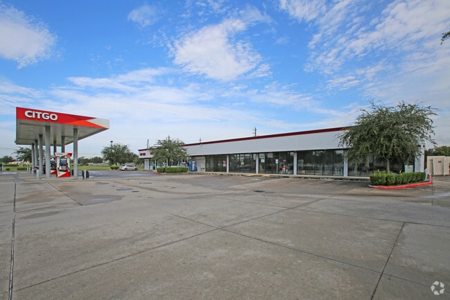


Property Detail
4201 Pasadena Blvd
0572260000031
TR 7A BLK 10 HOUSTON SURBURBAN ESTATES
Stripcommercialcenter
HARRIS
B and X Area of moderate flood hazard, usually the area between the limits of the 100-year and 500-year floods.
Texas
2024
1.27 AC
2025
NASA/Clear Lake
342400
Houston
9,250 SF
Houston-Pasadena-The Woodlands, TX
NEARBY LISTINGS FOR SALE OR LEASE
-
-
No Photo
-
-
-
-
-
-
-
-
-
-
-
-
-
-
View all Pasadena listings for lease on LoopNet.com
DEMOGRAPHICS near 4201 Pasadena Blvd
1 mile
3 mile
5 mile
2025 Total Population
15,073
120,147
226,808
2030 Population
16,036
128,116
242,072
Pop Growth 2025-2030
+ 6.39%
+ 6.63%
+ 6.73%
Average Age
37
37
37
2025 Total Households
5,159
40,868
75,699
HH Growth 2025-2030
+ 6.49%
+ 6.78%
+ 6.89%
Median Household Inc
$73,463
$71,142
$66,587
Avg Household Size
2.80
2.90
2.90
2025 Avg HH Vehicles
2.00
2.00
2.00
Median Home Value
$222,651
$235,426
$235,375
Median Year Built
1977
1977
1977
Nearby Places
Map Layers
Map Styles
 Street
 Aerial
Layers
 Traffic
 Biking
Places
Listings with unknown addresses are not visible on the map
- Restaurants
- Banks
- Shops
- Fitness
- Groceries
PUBLIC TRANSPORTATION
AIRPORT
William P Hobby
Drive
Walk
Distance
William P Hobby
25 min
13.0 mi
George Bush Intcntl/Houston
Drive
Walk
Distance
George Bush Intcntl/Houston
37 min
29.5 mi
Freight Ports
Port of Houston
Drive
Walk
Distance
Port of Houston
20 min
11.1 mi
SALE & LEASE HISTORY
LISTING DATE
SALE/LEASE

Jun 12, 2019
For Lease
Aug 07, 2023
For Lease
Nearby Properties
Address
Land Use
TOTAL SIZE
Lot Size
Zoning
Address
Land Use
TOTAL SIZE
Lot Size
Zoning
188.11 AC
Address
Land Use
TOTAL SIZE
Lot Size
Zoning
1,456,582 SF
93.83 AC
Address
Land Use
TOTAL SIZE
Lot Size
Zoning
19.38 AC
Address
Land Use
TOTAL SIZE
Lot Size
Zoning
155.61 AC
Address
Land Use
TOTAL SIZE
Lot Size
Zoning
606,550 SF
31.17 AC
Address
Land Use
TOTAL SIZE
Lot Size
Zoning
552,961 SF
25.01 AC
Address
Land Use
TOTAL SIZE
Lot Size
Zoning
188.11 AC
Address
Land Use
TOTAL SIZE
Lot Size
Zoning
345,420 SF
4.02 AC
Address
Land Use
TOTAL SIZE
Lot Size
Zoning
371,097 SF
10.32 AC
Address
Land Use
TOTAL SIZE
Lot Size
Zoning
411,046 SF
46.92 AC
Address
Land Use
TOTAL SIZE
Lot Size
Zoning
236,508 SF
24.19 AC
Address
Land Use
TOTAL SIZE
Lot Size
Zoning
265,567 SF
14.86 AC
Address
Land Use
TOTAL SIZE
Lot Size
Zoning
488,281 SF
26.48 AC
Address
Land Use
TOTAL SIZE
Lot Size
Zoning
155.74 AC
Address
Land Use
TOTAL SIZE
Lot Size
Zoning
2,367,893 SF
39.85 AC
Address
Land Use
TOTAL SIZE
Lot Size
Zoning
403,776 SF
21.06 AC
Address
Land Use
TOTAL SIZE
Lot Size
Zoning
173,293 SF
19.70 AC
Address
Land Use
TOTAL SIZE
Lot Size
Zoning
2,131,181 SF
118.10 AC
Address
Land Use
TOTAL SIZE
Lot Size
Zoning
135,331 SF
5 AC
Address
Land Use
TOTAL SIZE
Lot Size
Zoning
359,223 SF
17.24 AC
Address
Land Use
TOTAL SIZE
Lot Size
Zoning
222.82 AC
Address
Land Use
TOTAL SIZE
Lot Size
Zoning
283,010 SF
14.61 AC
Address
Land Use
TOTAL SIZE
Lot Size
Zoning
297,900 SF
17.72 AC
Address
Land Use
TOTAL SIZE
Lot Size
Zoning
260,915 SF
15.98 AC
Address
Land Use
TOTAL SIZE
Lot Size
Zoning
147,671 SF
17.84 AC
Address
Land Use
TOTAL SIZE
Lot Size
Zoning
175.54 AC
Address
Land Use
TOTAL SIZE
Lot Size
Zoning
563,016 SF
19.84 AC
Address
Land Use
TOTAL SIZE
Lot Size
Zoning
160,000 SF
16.46 AC
Address
Land Use
TOTAL SIZE
Lot Size
Zoning
460,310 SF
23.40 AC
Address
Land Use
TOTAL SIZE
Lot Size
Zoning
218,825 SF
12.23 AC
The World's #1 Commercial Real Estate Marketplace
Connect with us
© 2026 CoStar Group
The information above has been obtained from sources believed reliable. While we do not doubt its accuracy we have not verified it and make no guarantee, warranty or representation about it. It is your responsibility to independently confirm its accuracy and completeness. Any projections, opinions, assumptions, or estimates used are for example only and do not represent the current or future performance of the property. The value of this transaction to you depends on tax and other factors which should be evaluated by your tax, financial, and legal advisors. You and your advisors should conduct a careful, independent investigation of the property to determine to your satisfaction the suitability of the property for your needs.