Property Record
4201 Regent Ave N, Minneapolis, MN 55422

NEARBY LISTINGS FOR SALE OR LEASE
-
-
View all Minneapolis listings for sale on LoopNet.com
Property Detail
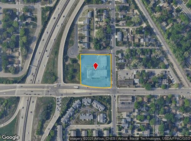
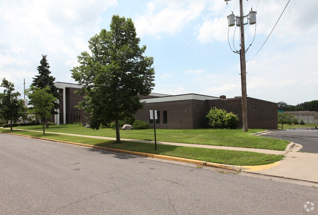
4201 Regent Ave N
Minneapolis-St. Paul-Bloomington, MN-WI
Unplatted 06 029 24
06-029-24-22-0003
UNPLATTED 06 029 24 COM AT SE COR OF NW 1/4 OF NW 1/4 TH N 330 FT TH W 330 FT TH S 330 FT TH E 330 FT TO BEG EX STREETS IRREGULAR
Commercialnec
Hennepin
X
Minnesota
27053C0211F
1.77 AC
0
Northwest
2024
Minneapolis/St Paul
021300
DEMOGRAPHICS near 4201 Regent Ave N
1 Mile
3 Mile
5 Mile
2024 Total Population
14,233
129,194
295,800
2029 Population
13,956
126,711
291,003
Pop Growth 2024-2029
(1.95%)
(1.92%)
(1.62%)
Average Age
41
38
38
2024 Total Households
6,130
49,229
116,606
HH Growth 2024-2029
(1.97%)
(2.10%)
(1.67%)
Median Household Inc
$68,287
$67,748
$71,422
Avg Household Size
2.20
2.50
2.40
2024 Avg HH Vehicles
2.00
2.00
2.00
Median Home Value
$250,353
$247,758
$265,468
Median Year Built
1957
1959
1966
Nearby Places
Map Layers
Map Styles
 Street
 Aerial
- Restaurants
- Banks
- Shops
- Fitness
- Groceries
PUBLIC TRANSPORTATION
COMMUTER RAIL
Target Field Station (Northstar Corridor - Northstar Commuter Rail)
DRIVE
WALK
Distance
Target Field Station (Northstar Corridor - Northstar Commuter Rail)
14 min
5.6 mi
Fridley Station (Northstar Corridor - Northstar Commuter Rail)
DRIVE
WALK
Distance
Fridley Station (Northstar Corridor - Northstar Commuter Rail)
11 min
5.9 mi
AIRPORT
Minneapolis-St Paul International/Wold-Chamberlain
DRIVE
WALK
Distance
Minneapolis-St Paul International/Wold-Chamberlain
30 min
20.6 mi
Nearby Properties
Address
Land Use
TOTAL SIZE
Lot Size
Zoning
Address
Land Use
TOTAL SIZE
Lot Size
Zoning
17.26 AC
Address
Land Use
TOTAL SIZE
Lot Size
Zoning
Address
Land Use
TOTAL SIZE
Lot Size
Zoning
Address
Land Use
TOTAL SIZE
Lot Size
Zoning
Address
Land Use
TOTAL SIZE
Lot Size
Zoning
Address
Land Use
TOTAL SIZE
Lot Size
Zoning
12.38 AC
Address
Land Use
TOTAL SIZE
Lot Size
Zoning
351,351 SF
17.98 AC
Address
Land Use
TOTAL SIZE
Lot Size
Zoning
20.48 AC
Address
Land Use
TOTAL SIZE
Lot Size
Zoning
19.10 AC
Address
Land Use
TOTAL SIZE
Lot Size
Zoning
Address
Land Use
TOTAL SIZE
Lot Size
Zoning
14.04 AC
Address
Land Use
TOTAL SIZE
Lot Size
Zoning
255,324 SF
15.22 AC
Address
Land Use
TOTAL SIZE
Lot Size
Zoning
106,897 SF
4.37 AC
Address
Land Use
TOTAL SIZE
Lot Size
Zoning
Address
Land Use
TOTAL SIZE
Lot Size
Zoning
Address
Land Use
TOTAL SIZE
Lot Size
Zoning
4.34 AC
Address
Land Use
TOTAL SIZE
Lot Size
Zoning
Address
Land Use
TOTAL SIZE
Lot Size
Zoning
Address
Land Use
TOTAL SIZE
Lot Size
Zoning
21.10 AC
Address
Land Use
TOTAL SIZE
Lot Size
Zoning
13.07 AC
Address
Land Use
TOTAL SIZE
Lot Size
Zoning
35,762 SF
4.48 AC
Address
Land Use
TOTAL SIZE
Lot Size
Zoning
9.89 AC
Address
Land Use
TOTAL SIZE
Lot Size
Zoning
10.31 AC
Address
Land Use
TOTAL SIZE
Lot Size
Zoning
72.58 AC
Address
Land Use
TOTAL SIZE
Lot Size
Zoning
10.31 AC
Address
Land Use
TOTAL SIZE
Lot Size
Zoning
10.59 AC
Address
Land Use
TOTAL SIZE
Lot Size
Zoning
Address
Land Use
TOTAL SIZE
Lot Size
Zoning
7.91 AC
Address
Land Use
TOTAL SIZE
Lot Size
Zoning
15.54 AC
Address
Land Use
TOTAL SIZE
Lot Size
Zoning
The World's #1 Commercial Real Estate Marketplace
Connect with us
© 2025 CoStar Group
The information above has been obtained from sources believed reliable. While we do not doubt its accuracy we have not verified it and make no guarantee, warranty or representation about it. It is your responsibility to independently confirm its accuracy and completeness. Any projections, opinions, assumptions, or estimates used are for example only and do not represent the current or future performance of the property. The value of this transaction to you depends on tax and other factors which should be evaluated by your tax, financial, and legal advisors. You and your advisors should conduct a careful, independent investigation of the property to determine to your satisfaction the suitability of the property for your needs.