Property Record
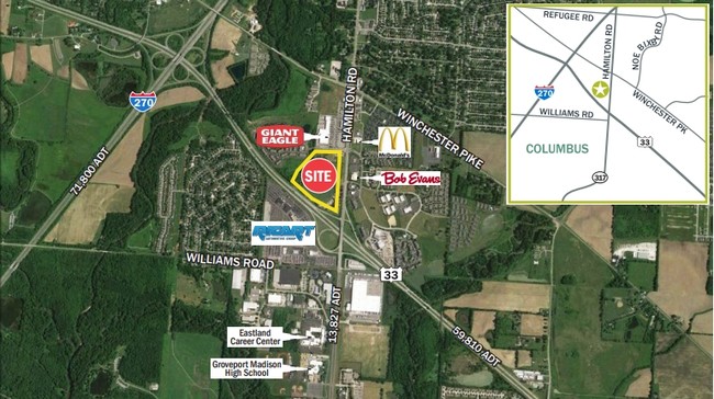
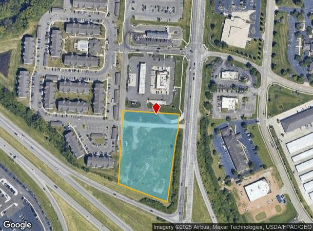
4015 S Hamilton Rd, Groveport, OH 43125
NEARBY LISTINGS FOR SALE OR LEASE
Property Detail
4015 S Hamilton Rd
530-193321
Us Congress Lands
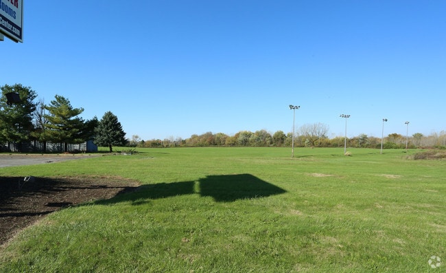
Commercialacreage
HAMILTON ROAD R21 T11 S9 3.388 ACRES
AE
Franklin
39049C0344K
Ohio
2024
3.39 AC
2024
East
009440
Columbus
4,794 SF
Columbus, OH
DEMOGRAPHICS near 4015 S Hamilton Rd
1 Mile
3 Mile
5 Mile
2024 Total Population
6,212
55,659
180,603
2029 Population
6,195
55,840
181,317
Pop Growth 2024-2029
(0.27%)
+ 0.33%
+ 0.40%
Average Age
40
37
37
2024 Total Households
2,753
22,147
72,039
HH Growth 2024-2029
(0.33%)
+ 0.25%
+ 0.35%
Median Household Inc
$70,615
$55,127
$53,627
Avg Household Size
2.20
2.40
2.40
2024 Avg HH Vehicles
2.00
2.00
2.00
Median Home Value
$157,048
$153,061
$159,682
Median Year Built
1981
1977
1975
Nearby Places
- Restaurants
- Banks
- Shops
- Fitness
- Groceries
PUBLIC TRANSPORTATION
AIRPORT
Rickenbacker International
DRIVE
WALK
Distance
Rickenbacker International
13 min
7.0 mi
John Glenn Columbus International
DRIVE
WALK
Distance
John Glenn Columbus International
17 min
10.1 mi
Freight Ports
Port of Toledo
DRIVE
WALK
Distance
Port of Toledo
195 min
158.3 mi
SALE & LEASE HISTORY
LISTING DATE
SALE/LEASE

Dec 13, 2017
For Sale
Nearby Properties
Address
Land Use
TOTAL SIZE
Lot Size
Zoning
Address
Land Use
TOTAL SIZE
Lot Size
Zoning
471,215 SF
49.74 AC
Address
Land Use
TOTAL SIZE
Lot Size
Zoning
230,994 SF
23.82 AC
Address
Land Use
TOTAL SIZE
Lot Size
Zoning
307,190 SF
55.18 AC
Address
Land Use
TOTAL SIZE
Lot Size
Zoning
181,204 SF
22.90 AC
Address
Land Use
TOTAL SIZE
Lot Size
Zoning
68,492 SF
23.63 AC
Address
Land Use
TOTAL SIZE
Lot Size
Zoning
250,174 SF
178.12 AC
Address
Land Use
TOTAL SIZE
Lot Size
Zoning
478,544 SF
23.04 AC
Address
Land Use
TOTAL SIZE
Lot Size
Zoning
462,840 SF
27.07 AC
Address
Land Use
TOTAL SIZE
Lot Size
Zoning
446,160 SF
91.12 AC
Address
Land Use
TOTAL SIZE
Lot Size
Zoning
446,160 SF
22.71 AC
Address
Land Use
TOTAL SIZE
Lot Size
Zoning
107,200 SF
24.72 AC
Address
Land Use
TOTAL SIZE
Lot Size
Zoning
69,070 SF
20.06 AC
Address
Land Use
TOTAL SIZE
Lot Size
Zoning
604,078 SF
50.18 AC
Address
Land Use
TOTAL SIZE
Lot Size
Zoning
29,311 SF
24.95 AC
Address
Land Use
TOTAL SIZE
Lot Size
Zoning
159,719 SF
36.24 AC
Address
Land Use
TOTAL SIZE
Lot Size
Zoning
175,313 SF
27.10 AC
Address
Land Use
TOTAL SIZE
Lot Size
Zoning
324,000 SF
20.91 AC
Address
Land Use
TOTAL SIZE
Lot Size
Zoning
115,095 SF
14.02 AC
Address
Land Use
TOTAL SIZE
Lot Size
Zoning
259,616 SF
23.54 AC
Address
Land Use
TOTAL SIZE
Lot Size
Zoning
600,255 SF
40.27 AC
Address
Land Use
TOTAL SIZE
Lot Size
Zoning
319,720 SF
14.85 AC
Address
Land Use
TOTAL SIZE
Lot Size
Zoning
101,189 SF
22.58 AC
Address
Land Use
TOTAL SIZE
Lot Size
Zoning
241,040 SF
16.44 AC
Address
Land Use
TOTAL SIZE
Lot Size
Zoning
248,400 SF
15.53 AC
Address
Land Use
TOTAL SIZE
Lot Size
Zoning
569,216 SF
42.86 AC
Address
Land Use
TOTAL SIZE
Lot Size
Zoning
335,414 SF
19.53 AC
Address
Land Use
TOTAL SIZE
Lot Size
Zoning
66,617 SF
78.33 AC
Address
Land Use
TOTAL SIZE
Lot Size
Zoning
267,180 SF
13.72 AC
Address
Land Use
TOTAL SIZE
Lot Size
Zoning
31,968 SF
17.68 AC
Address
Land Use
TOTAL SIZE
Lot Size
Zoning
300,398 SF
12.08 AC
The World's #1 Commercial Real Estate Marketplace
Connect with us
© 2025 CoStar Group
The information above has been obtained from sources believed reliable. While we do not doubt its accuracy we have not verified it and make no guarantee, warranty or representation about it. It is your responsibility to independently confirm its accuracy and completeness. Any projections, opinions, assumptions, or estimates used are for example only and do not represent the current or future performance of the property. The value of this transaction to you depends on tax and other factors which should be evaluated by your tax, financial, and legal advisors. You and your advisors should conduct a careful, independent investigation of the property to determine to your satisfaction the suitability of the property for your needs.