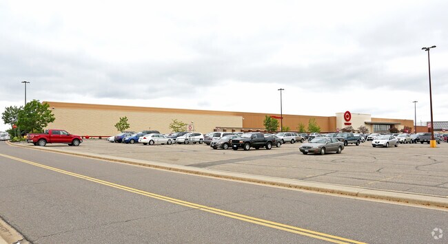
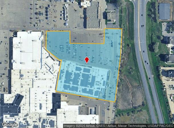
Property Record
4201 W Division St, Saint Cloud, MN 56301

NEARBY LISTINGS FOR SALE OR LEASE
Property Detail
4201 W Division St
St. Cloud, MN
Crossroads Addition Plat 3
82.46411.0028
LOTS 3 & 4 CROSSROADS ADDITION PLAT 3 SECTION 16 TOWNSHIP 124 RANGE 028 CROSSROADS ADDITION PLAT 3 SECTION 16 TOWNSHIP 124
Commercialnec
Stearns
X
Minnesota
27145C0640E
3-4
2025
8.32 AC
2025
Stearns County
000501
Minneapolis/St Paul
DEMOGRAPHICS near 4201 W Division St
1 Mile
3 Mile
5 Mile
2024 Total Population
6,932
63,657
111,261
2029 Population
7,212
65,834
115,004
Pop Growth 2024-2029
+ 4.04%
+ 3.42%
+ 3.36%
Average Age
40
37
37
2024 Total Households
2,953
25,307
44,167
HH Growth 2024-2029
+ 4.17%
+ 3.60%
+ 3.41%
Median Household Inc
$51,207
$53,126
$55,720
Avg Household Size
2.30
2.30
2.30
2024 Avg HH Vehicles
2.00
2.00
2.00
Median Home Value
$155,704
$182,451
$195,425
Median Year Built
1977
1981
1985
Nearby Places
Map Layers
Map Styles
 Street
 Aerial
- Restaurants
- Banks
- Shops
- Fitness
- Groceries
PUBLIC TRANSPORTATION
COMMUTER RAIL
St. Cloud Amtrak Station (Empire Builder - Amtrak)
DRIVE
WALK
Distance
St. Cloud Amtrak Station (Empire Builder - Amtrak)
8 min
3.4 mi
Freight Ports
Port Milwaukee
DRIVE
WALK
Distance
Port Milwaukee
451 min
405.4 mi
Nearby Properties
Address
Land Use
TOTAL SIZE
Lot Size
Zoning
Address
Land Use
TOTAL SIZE
Lot Size
Zoning
16.60 AC
MD
Address
Land Use
TOTAL SIZE
Lot Size
Zoning
38.97 AC
Address
Land Use
TOTAL SIZE
Lot Size
Zoning
639,000 SF
216.67 AC
PUD28
Address
Land Use
TOTAL SIZE
Lot Size
Zoning
113,316 SF
31.99 AC
Address
Land Use
TOTAL SIZE
Lot Size
Zoning
107,306 SF
2.11 AC
C4
Address
Land Use
TOTAL SIZE
Lot Size
Zoning
105,833 SF
4.61 AC
C4
Address
Land Use
TOTAL SIZE
Lot Size
Zoning
52,983 SF
22 AC
Address
Land Use
TOTAL SIZE
Lot Size
Zoning
157,266 SF
0.94 AC
R2
Address
Land Use
TOTAL SIZE
Lot Size
Zoning
238,920 SF
5.40 AC
R3
Address
Land Use
TOTAL SIZE
Lot Size
Zoning
281,127 SF
3.10 AC
PUD95
Address
Land Use
TOTAL SIZE
Lot Size
Zoning
70,971 SF
11.40 AC
PUD57
Address
Land Use
TOTAL SIZE
Lot Size
Zoning
365,299 SF
28.68 AC
R1
Address
Land Use
TOTAL SIZE
Lot Size
Zoning
177,951 SF
8.26 AC
R3
Address
Land Use
TOTAL SIZE
Lot Size
Zoning
125,278 SF
11.01 AC
C5
Address
Land Use
TOTAL SIZE
Lot Size
Zoning
152,055 SF
2.33 AC
R3
Address
Land Use
TOTAL SIZE
Lot Size
Zoning
10.46 AC
Address
Land Use
TOTAL SIZE
Lot Size
Zoning
344,031 SF
64.88 AC
PUD28
Address
Land Use
TOTAL SIZE
Lot Size
Zoning
165,758 SF
3 AC
R3
Address
Land Use
TOTAL SIZE
Lot Size
Zoning
184,285 SF
13.37 AC
Address
Land Use
TOTAL SIZE
Lot Size
Zoning
628,000 SF
40.51 AC
PUD16
Address
Land Use
TOTAL SIZE
Lot Size
Zoning
115,298 SF
8.50 AC
R5
Address
Land Use
TOTAL SIZE
Lot Size
Zoning
5.34 AC
Address
Land Use
TOTAL SIZE
Lot Size
Zoning
233,354 SF
7.30 AC
R5
Address
Land Use
TOTAL SIZE
Lot Size
Zoning
158,809 SF
2.67 AC
R3
Address
Land Use
TOTAL SIZE
Lot Size
Zoning
232,274 SF
2.94 AC
R3
Address
Land Use
TOTAL SIZE
Lot Size
Zoning
113,268 SF
12 AC
PUD32
Address
Land Use
TOTAL SIZE
Lot Size
Zoning
19.83 AC
Address
Land Use
TOTAL SIZE
Lot Size
Zoning
157,500 SF
1.25 AC
C3
Address
Land Use
TOTAL SIZE
Lot Size
Zoning
146,285 SF
19.10 AC
Address
Land Use
TOTAL SIZE
Lot Size
Zoning
105,123 SF
36.87 AC
R1
The World's #1 Commercial Real Estate Marketplace
Connect with us
© 2026 CoStar Group
The information above has been obtained from sources believed reliable. While we do not doubt its accuracy we have not verified it and make no guarantee, warranty or representation about it. It is your responsibility to independently confirm its accuracy and completeness. Any projections, opinions, assumptions, or estimates used are for example only and do not represent the current or future performance of the property. The value of this transaction to you depends on tax and other factors which should be evaluated by your tax, financial, and legal advisors. You and your advisors should conduct a careful, independent investigation of the property to determine to your satisfaction the suitability of the property for your needs.