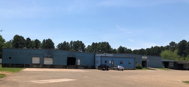
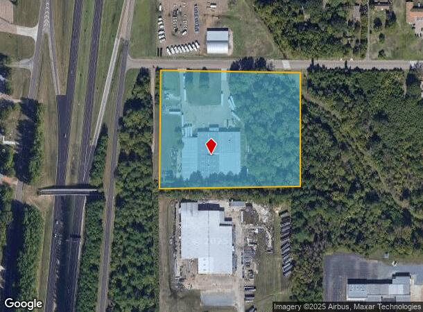
Property Record
4201 Waco St, Texarkana, TX 75501
NEARBY LISTINGS FOR SALE OR LEASE
Property Detail
4201 Waco St
03900003800
City Improvement Co Annex
Commercialnec
CITY IMPROVEMENT CO ANNEX LESS 96X 660 CARAUSTAR 2021-2433 03/08/21 BLK/TRACT 25 7.671 ACRES
AE
Bowie
48037C0365E
Texas
2024
7.67 AC
2025
Texas East Area
010400
Other Market Areas
58,400 SF
Texarkana, TX-AR
DEMOGRAPHICS near 4201 Waco St
1 Mile
3 Mile
5 Mile
2024 Total Population
2,016
30,067
73,327
2029 Population
2,010
30,203
73,649
Pop Growth 2024-2029
(0.30%)
+ 0.45%
+ 0.44%
Average Age
37
38
39
2024 Total Households
775
11,659
28,876
HH Growth 2024-2029
(0.13%)
+ 0.49%
+ 0.44%
Median Household Inc
$52,880
$36,906
$43,393
Avg Household Size
2.50
2.40
2.30
2024 Avg HH Vehicles
2.00
2.00
2.00
Median Home Value
$137,423
$118,392
$134,490
Median Year Built
1974
1979
1979
Nearby Places
Map Layers
Map Styles
 Street
 Aerial
- Restaurants
- Banks
- Shops
- Fitness
- Groceries
PUBLIC TRANSPORTATION
COMMUTER RAIL
DRIVE
WALK
Distance
8 min
3.8 mi
AIRPORT
Texarkana Regional-Webb Field
DRIVE
WALK
Distance
Texarkana Regional-Webb Field
18 min
7.9 mi
SALE & LEASE HISTORY
LISTING DATE
SALE/LEASE

Jul 05, 2019
For Sale
Nearby Properties
Address
Land Use
TOTAL SIZE
Lot Size
Zoning
Address
Land Use
TOTAL SIZE
Lot Size
Zoning
37.76 AC
Address
Land Use
TOTAL SIZE
Lot Size
Zoning
415,000 SF
56.08 AC
Address
Land Use
TOTAL SIZE
Lot Size
Zoning
Address
Land Use
TOTAL SIZE
Lot Size
Zoning
Address
Land Use
TOTAL SIZE
Lot Size
Zoning
11.66 AC
Address
Land Use
TOTAL SIZE
Lot Size
Zoning
3,642 SF
24.74 AC
Address
Land Use
TOTAL SIZE
Lot Size
Zoning
19,189 SF
Address
Land Use
TOTAL SIZE
Lot Size
Zoning
2.07 AC
Address
Land Use
TOTAL SIZE
Lot Size
Zoning
Address
Land Use
TOTAL SIZE
Lot Size
Zoning
8.19 AC
Address
Land Use
TOTAL SIZE
Lot Size
Zoning
533,299 SF
50.60 AC
Address
Land Use
TOTAL SIZE
Lot Size
Zoning
107,400 SF
5.83 AC
Address
Land Use
TOTAL SIZE
Lot Size
Zoning
100,327 SF
Address
Land Use
TOTAL SIZE
Lot Size
Zoning
166,777 SF
9 AC
Address
Land Use
TOTAL SIZE
Lot Size
Zoning
87,452 SF
2.32 AC
Address
Land Use
TOTAL SIZE
Lot Size
Zoning
190,026 SF
30.86 AC
Address
Land Use
TOTAL SIZE
Lot Size
Zoning
62,256 SF
9.67 AC
Address
Land Use
TOTAL SIZE
Lot Size
Zoning
32.42 AC
Address
Land Use
TOTAL SIZE
Lot Size
Zoning
82,125 SF
13.71 AC
Address
Land Use
TOTAL SIZE
Lot Size
Zoning
124,978 SF
36.18 AC
Address
Land Use
TOTAL SIZE
Lot Size
Zoning
175,650 SF
15.56 AC
Address
Land Use
TOTAL SIZE
Lot Size
Zoning
125,400 SF
9.47 AC
Address
Land Use
TOTAL SIZE
Lot Size
Zoning
160,484 SF
10.01 AC
Address
Land Use
TOTAL SIZE
Lot Size
Zoning
89,848 SF
7.15 AC
Address
Land Use
TOTAL SIZE
Lot Size
Zoning
96,827 SF
11.16 AC
Address
Land Use
TOTAL SIZE
Lot Size
Zoning
70,448 SF
7.61 AC
Address
Land Use
TOTAL SIZE
Lot Size
Zoning
152,914 SF
7.69 AC
Address
Land Use
TOTAL SIZE
Lot Size
Zoning
122,640 SF
18.68 AC
Address
Land Use
TOTAL SIZE
Lot Size
Zoning
100,000 SF
5.92 AC
Address
Land Use
TOTAL SIZE
Lot Size
Zoning
74,246 SF
1.34 AC
The World's #1 Commercial Real Estate Marketplace
Connect with us
© 2025 CoStar Group
The information above has been obtained from sources believed reliable. While we do not doubt its accuracy we have not verified it and make no guarantee, warranty or representation about it. It is your responsibility to independently confirm its accuracy and completeness. Any projections, opinions, assumptions, or estimates used are for example only and do not represent the current or future performance of the property. The value of this transaction to you depends on tax and other factors which should be evaluated by your tax, financial, and legal advisors. You and your advisors should conduct a careful, independent investigation of the property to determine to your satisfaction the suitability of the property for your needs.