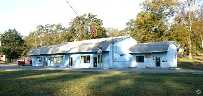
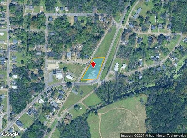
Property Record
4202 Huntsville Ave, Brighton, AL 35020
NEARBY LISTINGS FOR SALE OR LEASE
Property Detail
4202 Huntsville Ave
Birmingham-Hoover, AL
Deacys Sub *
30-00-34-2-002-002.000
LOTS 36-37-38 & 39 DEACYS SUB OF LOTS 4-5 BL 1 W D SMITH EST
Vacantlandnec
Jefferson
AE
Alabama
01073C0537H
36
2023
0.76 AC
2024
Bessemer
0136013002
Birmingham
DEMOGRAPHICS near 4202 Huntsville Ave
1 Mile
3 Mile
5 Mile
2024 Total Population
5,409
38,540
92,583
2029 Population
5,462
38,266
91,634
Pop Growth 2024-2029
+ 0.98%
(0.71%)
(1.03%)
Average Age
41
41
40
2024 Total Households
2,159
15,468
37,134
HH Growth 2024-2029
+ 0.79%
(0.82%)
(1.15%)
Median Household Inc
$35,465
$42,062
$45,167
Avg Household Size
2.40
2.40
2.40
2024 Avg HH Vehicles
1.00
2.00
2.00
Median Home Value
$68,986
$109,965
$118,603
Median Year Built
1964
1963
1965
Nearby Places
Map Layers
Map Styles
 Street
 Aerial
- Restaurants
- Banks
- Shops
- Fitness
- Groceries
PUBLIC TRANSPORTATION
AIRPORT
Birmingham-Shuttlesworth International
DRIVE
WALK
Distance
Birmingham-Shuttlesworth International
24 min
18.5 mi
Freight Ports
Port of Mobile
DRIVE
WALK
Distance
Port of Mobile
282 min
240.3 mi
Nearby Properties
Address
Land Use
TOTAL SIZE
Lot Size
Zoning
Address
Land Use
TOTAL SIZE
Lot Size
Zoning
75,840 SF
20.10 AC
I3
Address
Land Use
TOTAL SIZE
Lot Size
Zoning
321,783 SF
19.40 AC
MXD
Address
Land Use
TOTAL SIZE
Lot Size
Zoning
224,184 SF
65.60 AC
I3
Address
Land Use
TOTAL SIZE
Lot Size
Zoning
1,244,986 SF
I2
Address
Land Use
TOTAL SIZE
Lot Size
Zoning
2,573,547 SF
112 AC
I2
Address
Land Use
TOTAL SIZE
Lot Size
Zoning
460,483 SF
20 AC
I3
Address
Land Use
TOTAL SIZE
Lot Size
Zoning
118,309 SF
88.50 AC
I3
Address
Land Use
TOTAL SIZE
Lot Size
Zoning
187,200 SF
22 AC
I3
Address
Land Use
TOTAL SIZE
Lot Size
Zoning
116,442 SF
2.67 AC
B6
Address
Land Use
TOTAL SIZE
Lot Size
Zoning
195,495 SF
28.97 AC
B3
Address
Land Use
TOTAL SIZE
Lot Size
Zoning
553,137 SF
87 AC
I2
Address
Land Use
TOTAL SIZE
Lot Size
Zoning
68,191 SF
16.20 AC
I3
Address
Land Use
TOTAL SIZE
Lot Size
Zoning
68,191 SF
12.50 AC
I3
Address
Land Use
TOTAL SIZE
Lot Size
Zoning
191,664 SF
14.73 AC
R4
Address
Land Use
TOTAL SIZE
Lot Size
Zoning
88.50 AC
I3
Address
Land Use
TOTAL SIZE
Lot Size
Zoning
136,115 SF
14.90 AC
C3
Address
Land Use
TOTAL SIZE
Lot Size
Zoning
145,300 SF
25 AC
R3
Address
Land Use
TOTAL SIZE
Lot Size
Zoning
288,000 SF
39.40 AC
I2-I
Address
Land Use
TOTAL SIZE
Lot Size
Zoning
219,210 SF
19.40 AC
M2
Address
Land Use
TOTAL SIZE
Lot Size
Zoning
230,088 SF
I3
Address
Land Use
TOTAL SIZE
Lot Size
Zoning
66,928 SF
5.70 AC
B2-R
Address
Land Use
TOTAL SIZE
Lot Size
Zoning
77,902 SF
44 AC
I3
Address
Land Use
TOTAL SIZE
Lot Size
Zoning
1,090,237 SF
28.10 AC
I4
Address
Land Use
TOTAL SIZE
Lot Size
Zoning
66,900 SF
3.78 AC
I4
Address
Land Use
TOTAL SIZE
Lot Size
Zoning
58,822 SF
7.80 AC
B3
Address
Land Use
TOTAL SIZE
Lot Size
Zoning
1,200 SF
13.40 AC
R3
Address
Land Use
TOTAL SIZE
Lot Size
Zoning
69,344 SF
2.30 AC
B-1
Address
Land Use
TOTAL SIZE
Lot Size
Zoning
26,234 SF
3.30 AC
B2
Address
Land Use
TOTAL SIZE
Lot Size
Zoning
157,183 SF
6.50 AC
B2
Address
Land Use
TOTAL SIZE
Lot Size
Zoning
366,421 SF
21 AC
I3
The World's #1 Commercial Real Estate Marketplace
Connect with us
© 2025 CoStar Group
The information above has been obtained from sources believed reliable. While we do not doubt its accuracy we have not verified it and make no guarantee, warranty or representation about it. It is your responsibility to independently confirm its accuracy and completeness. Any projections, opinions, assumptions, or estimates used are for example only and do not represent the current or future performance of the property. The value of this transaction to you depends on tax and other factors which should be evaluated by your tax, financial, and legal advisors. You and your advisors should conduct a careful, independent investigation of the property to determine to your satisfaction the suitability of the property for your needs.