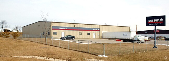
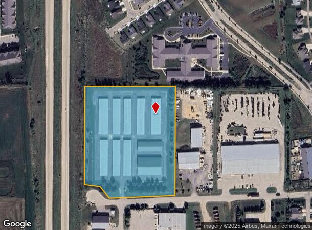
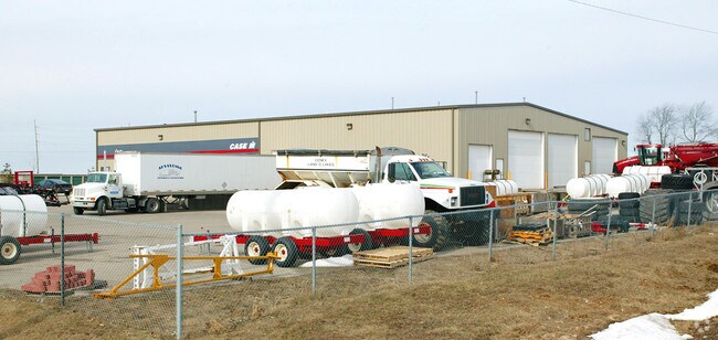
Property Record
4202 Reardon Rd, Deforest, WI 53532
NEARBY LISTINGS FOR SALE OR LEASE
Property Detail
4202 Reardon Rd
Madison, WI
LOT 1 CSM 5012 CS22/214-216 R8626/71-8/14/86 DESCR AS SEC 33-9-10 PRT NW1/4NW1/4 7.626 ACRES EXC TO WDOT IN 4849157
0910-332-8561-1
Dane
Commercialnec
Wisconsin
X
1
55025C0254H
7.10 AC
2024
Outlying Dane East
2024
Milwaukee/Madison
013301
DEMOGRAPHICS near 4202 Reardon Rd
1 Mile
3 Mile
5 Mile
2024 Total Population
3,230
21,137
59,612
2029 Population
3,407
22,127
62,044
Pop Growth 2024-2029
+ 5.48%
+ 4.68%
+ 4.08%
Average Age
37
38
38
2024 Total Households
1,200
7,855
24,017
HH Growth 2024-2029
+ 5.58%
+ 4.75%
+ 4.23%
Median Household Inc
$128,967
$104,203
$90,281
Avg Household Size
2.70
2.70
2.40
2024 Avg HH Vehicles
2.00
2.00
2.00
Median Home Value
$396,979
$344,960
$329,809
Median Year Built
1992
1995
1995
Nearby Places
- Restaurants
- Banks
- Shops
- Fitness
- Groceries
PUBLIC TRANSPORTATION
AIRPORT
Dane County Regional/Truax Field
DRIVE
WALK
Distance
Dane County Regional/Truax Field
15 min
8.7 mi
Freight Ports
Port Milwaukee
DRIVE
WALK
Distance
Port Milwaukee
97 min
82.8 mi
Nearby Properties
Address
Land Use
TOTAL SIZE
Lot Size
Zoning
Address
Land Use
TOTAL SIZE
Lot Size
Zoning
385,400 SF
62.07 AC
IL
Address
Land Use
TOTAL SIZE
Lot Size
Zoning
48.24 AC
Address
Land Use
TOTAL SIZE
Lot Size
Zoning
Address
Land Use
TOTAL SIZE
Lot Size
Zoning
37.54 AC
Address
Land Use
TOTAL SIZE
Lot Size
Zoning
24.70 AC
Address
Land Use
TOTAL SIZE
Lot Size
Zoning
Address
Land Use
TOTAL SIZE
Lot Size
Zoning
Address
Land Use
TOTAL SIZE
Lot Size
Zoning
3.77 AC
Address
Land Use
TOTAL SIZE
Lot Size
Zoning
16.64 AC
Address
Land Use
TOTAL SIZE
Lot Size
Zoning
11.01 AC
C2
Address
Land Use
TOTAL SIZE
Lot Size
Zoning
13.27 AC
ETZ
Address
Land Use
TOTAL SIZE
Lot Size
Zoning
20.59 AC
C2
Address
Land Use
TOTAL SIZE
Lot Size
Zoning
3.60 AC
Address
Land Use
TOTAL SIZE
Lot Size
Zoning
2.59 AC
Address
Land Use
TOTAL SIZE
Lot Size
Zoning
8.19 AC
Address
Land Use
TOTAL SIZE
Lot Size
Zoning
14.75 AC
Address
Land Use
TOTAL SIZE
Lot Size
Zoning
12.30 AC
C2
Address
Land Use
TOTAL SIZE
Lot Size
Zoning
3.72 AC
R-4
Address
Land Use
TOTAL SIZE
Lot Size
Zoning
14.52 AC
ETZ
Address
Land Use
TOTAL SIZE
Lot Size
Zoning
Address
Land Use
TOTAL SIZE
Lot Size
Zoning
47,012 SF
10.92 AC
IG
Address
Land Use
TOTAL SIZE
Lot Size
Zoning
Address
Land Use
TOTAL SIZE
Lot Size
Zoning
11.41 AC
Address
Land Use
TOTAL SIZE
Lot Size
Zoning
38.60 AC
Address
Land Use
TOTAL SIZE
Lot Size
Zoning
7.71 AC
ETZ
Address
Land Use
TOTAL SIZE
Lot Size
Zoning
3.72 AC
C2
Address
Land Use
TOTAL SIZE
Lot Size
Zoning
6.63 AC
Address
Land Use
TOTAL SIZE
Lot Size
Zoning
8.13 AC
Address
Land Use
TOTAL SIZE
Lot Size
Zoning
6.60 AC
C2
Address
Land Use
TOTAL SIZE
Lot Size
Zoning
13.01 AC
C2
The World's #1 Commercial Real Estate Marketplace
Connect with us
© 2025 CoStar Group
The information above has been obtained from sources believed reliable. While we do not doubt its accuracy we have not verified it and make no guarantee, warranty or representation about it. It is your responsibility to independently confirm its accuracy and completeness. Any projections, opinions, assumptions, or estimates used are for example only and do not represent the current or future performance of the property. The value of this transaction to you depends on tax and other factors which should be evaluated by your tax, financial, and legal advisors. You and your advisors should conduct a careful, independent investigation of the property to determine to your satisfaction the suitability of the property for your needs.