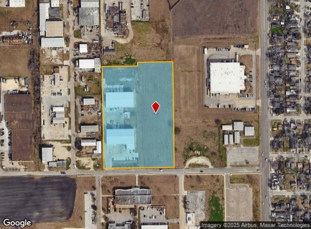
Property Record
4202 Santa Elena St, Corpus Christi, TX 78405

NEARBY LISTINGS FOR SALE OR LEASE
Property Detail
4202 Santa Elena St
Corpus Christi, TX
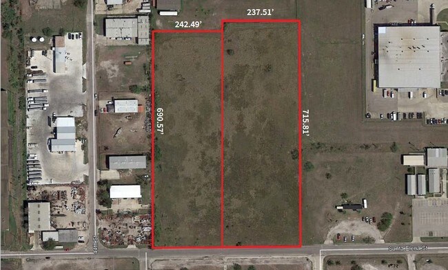
C C Industrial District #2
203329
C C INDUSTRIAL DIST 2 LTS W & X BK 10
Industrialgeneral
Nueces
X
Texas
48355C0315G
w&x
2024
7.75 AC
2025
West Side
001601
Corpus Christi
39,870 SF
DEMOGRAPHICS near 4202 Santa Elena St
1 Mile
3 Mile
5 Mile
2024 Total Population
7,243
64,836
112,806
2029 Population
7,181
64,498
111,762
Pop Growth 2024-2029
(0.86%)
(0.52%)
(0.93%)
Average Age
39
39
39
2024 Total Households
2,469
22,928
40,721
HH Growth 2024-2029
(0.97%)
(0.49%)
(0.92%)
Median Household Inc
$36,174
$35,099
$42,928
Avg Household Size
2.80
2.60
2.60
2024 Avg HH Vehicles
2.00
2.00
2.00
Median Home Value
$60,549
$73,748
$105,929
Median Year Built
1963
1959
1960
Nearby Places
- Restaurants
- Banks
- Shops
- Fitness
- Groceries
PUBLIC TRANSPORTATION
AIRPORT
Corpus Christi International
DRIVE
WALK
Distance
Corpus Christi International
11 min
5.4 mi
Freight Ports
Port of Corpus Christi
DRIVE
WALK
Distance
Port of Corpus Christi
7 min
4.2 mi
SALE & LEASE HISTORY
LISTING DATE
SALE/LEASE

Oct 24, 2024
For Sale
Apr 25, 2019
For Sale
Nearby Properties
Address
Land Use
TOTAL SIZE
Lot Size
Zoning
Address
Land Use
TOTAL SIZE
Lot Size
Zoning
382,448 SF
14.98 AC
Address
Land Use
TOTAL SIZE
Lot Size
Zoning
674,927 SF
10.54 AC
B4
Address
Land Use
TOTAL SIZE
Lot Size
Zoning
1 SF
62.73 AC
III
Address
Land Use
TOTAL SIZE
Lot Size
Zoning
15.10 AC
I3
Address
Land Use
TOTAL SIZE
Lot Size
Zoning
1 SF
13.71 AC
B5
Address
Land Use
TOTAL SIZE
Lot Size
Zoning
302,344 SF
5 AC
Address
Land Use
TOTAL SIZE
Lot Size
Zoning
1 SF
10.53 AC
I2
Address
Land Use
TOTAL SIZE
Lot Size
Zoning
72,106 SF
1.96 AC
B-5
Address
Land Use
TOTAL SIZE
Lot Size
Zoning
278,919 SF
39.27 AC
R1B
Address
Land Use
TOTAL SIZE
Lot Size
Zoning
105,979 SF
25 AC
I2SP92
Address
Land Use
TOTAL SIZE
Lot Size
Zoning
74,247 SF
6.39 AC
Address
Land Use
TOTAL SIZE
Lot Size
Zoning
75,120 SF
1.93 AC
B2
Address
Land Use
TOTAL SIZE
Lot Size
Zoning
67,009 SF
6.99 AC
R1B
Address
Land Use
TOTAL SIZE
Lot Size
Zoning
85,871 SF
18.68 AC
R1B
Address
Land Use
TOTAL SIZE
Lot Size
Zoning
11,109 SF
76.58 AC
R1B
Address
Land Use
TOTAL SIZE
Lot Size
Zoning
89,537 SF
11.35 AC
R1B
Address
Land Use
TOTAL SIZE
Lot Size
Zoning
177,545 SF
7.75 AC
B2
Address
Land Use
TOTAL SIZE
Lot Size
Zoning
52,121 SF
27.73 AC
Address
Land Use
TOTAL SIZE
Lot Size
Zoning
101,912 SF
13.89 AC
I-2
Address
Land Use
TOTAL SIZE
Lot Size
Zoning
74,261 SF
4.44 AC
R1B
Address
Land Use
TOTAL SIZE
Lot Size
Zoning
105.49 AC
R1B
Address
Land Use
TOTAL SIZE
Lot Size
Zoning
42,984 SF
5.20 AC
Address
Land Use
TOTAL SIZE
Lot Size
Zoning
145,296 SF
1.21 AC
B6
Address
Land Use
TOTAL SIZE
Lot Size
Zoning
72.29 AC
OCL
Address
Land Use
TOTAL SIZE
Lot Size
Zoning
94,600 SF
9.29 AC
R2
Address
Land Use
TOTAL SIZE
Lot Size
Zoning
129,210 SF
11.63 AC
R1B
Address
Land Use
TOTAL SIZE
Lot Size
Zoning
315,038 SF
1.38 AC
B-6
Address
Land Use
TOTAL SIZE
Lot Size
Zoning
73,595 SF
2.63 AC
B5
Address
Land Use
TOTAL SIZE
Lot Size
Zoning
123,098 SF
2.39 AC
A2
Address
Land Use
TOTAL SIZE
Lot Size
Zoning
94,524 SF
1.95 AC
SP
The World's #1 Commercial Real Estate Marketplace
Connect with us
© 2025 CoStar Group
The information above has been obtained from sources believed reliable. While we do not doubt its accuracy we have not verified it and make no guarantee, warranty or representation about it. It is your responsibility to independently confirm its accuracy and completeness. Any projections, opinions, assumptions, or estimates used are for example only and do not represent the current or future performance of the property. The value of this transaction to you depends on tax and other factors which should be evaluated by your tax, financial, and legal advisors. You and your advisors should conduct a careful, independent investigation of the property to determine to your satisfaction the suitability of the property for your needs.