Property Record
4203 Durham Rd, Kintnersville, PA 18930

NEARBY LISTINGS FOR SALE OR LEASE
-
-
View all Kintnersville listings for sale on LoopNet.com
Property Detail
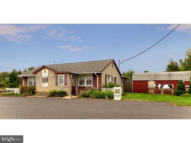
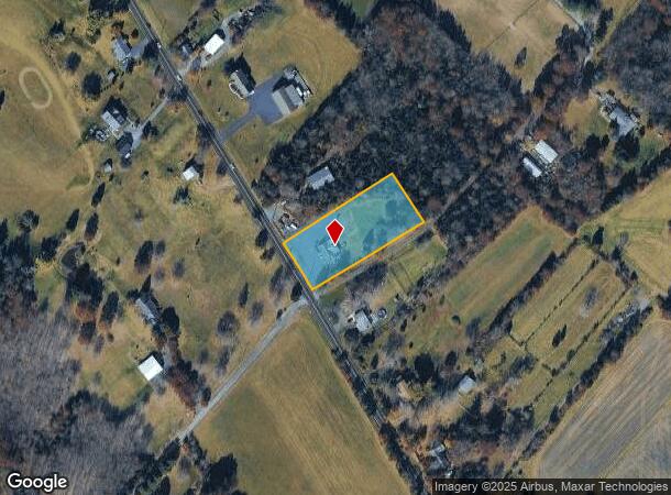
4203 Durham Rd
30-011-074-004
Ao Judd Co
Restaurantbuilding
1.2052A E S SR412 995 S T467
X
Bucks
42017C0068J
Pennsylvania
2024
1.21 AC
2025
Upper Bucks County
103700
Philadelphia
1,818 SF
Philadelphia-Camden-Wilmington, PA-NJ-DE-MD
DEMOGRAPHICS near 4203 Durham Rd
1 Mile
3 Mile
5 Mile
2024 Total Population
439
3,152
8,945
2029 Population
427
3,073
8,771
Pop Growth 2024-2029
(2.73%)
(2.51%)
(1.95%)
Average Age
47
48
48
2024 Total Households
179
1,304
3,709
HH Growth 2024-2029
(2.79%)
(2.53%)
(2.00%)
Median Household Inc
$103,289
$110,023
$111,083
Avg Household Size
2.50
2.40
2.40
2024 Avg HH Vehicles
2.00
2.00
3.00
Median Home Value
$386,904
$455,846
$498,411
Median Year Built
1959
1966
1970
Nearby Places
Map Layers
Map Styles
 Street
 Aerial
- Restaurants
- Banks
- Shops
- Fitness
- Groceries
PUBLIC TRANSPORTATION
AIRPORT
Lehigh Valley International
DRIVE
WALK
Distance
Lehigh Valley International
41 min
22.1 mi
Trenton Mercer
DRIVE
WALK
Distance
Trenton Mercer
51 min
29.9 mi
Freight Ports
Port of Philadelphia
DRIVE
WALK
Distance
Port of Philadelphia
68 min
40.2 mi
SALE & LEASE HISTORY
LISTING DATE
SALE/LEASE

Nov 01, 2024
For Sale
May 08, 2025
For Sale
Mar 12, 2019
For Sale
Jan 14, 2019
For Sale
Dec 12, 2018
For Sale
Nearby Properties
Address
Land Use
TOTAL SIZE
Lot Size
Zoning
Address
Land Use
TOTAL SIZE
Lot Size
Zoning
37,145 SF
13.69 AC
VC
Address
Land Use
TOTAL SIZE
Lot Size
Zoning
64.96 AC
VC
Address
Land Use
TOTAL SIZE
Lot Size
Zoning
12,476 SF
10.23 AC
R
Address
Land Use
TOTAL SIZE
Lot Size
Zoning
44,720 SF
8.45 AC
VC
Address
Land Use
TOTAL SIZE
Lot Size
Zoning
6,603 SF
45.40 AC
RR
Address
Land Use
TOTAL SIZE
Lot Size
Zoning
12,452 SF
15.94 AC
VR
Address
Land Use
TOTAL SIZE
Lot Size
Zoning
112.95 AC
RA
Address
Land Use
TOTAL SIZE
Lot Size
Zoning
11,572 SF
3.84 AC
VC
Address
Land Use
TOTAL SIZE
Lot Size
Zoning
17,287 SF
3.17 AC
VC
Address
Land Use
TOTAL SIZE
Lot Size
Zoning
20,400 SF
4.81 AC
C
Address
Land Use
TOTAL SIZE
Lot Size
Zoning
18,500 SF
9.20 AC
VC
Address
Land Use
TOTAL SIZE
Lot Size
Zoning
10,920 SF
1.72 AC
R
Address
Land Use
TOTAL SIZE
Lot Size
Zoning
15,918 SF
7.54 AC
VC
Address
Land Use
TOTAL SIZE
Lot Size
Zoning
18 AC
VC
Address
Land Use
TOTAL SIZE
Lot Size
Zoning
5,083 SF
67.54 AC
RA
Address
Land Use
TOTAL SIZE
Lot Size
Zoning
19,993 SF
4 AC
I
Address
Land Use
TOTAL SIZE
Lot Size
Zoning
12,088 SF
2.38 AC
VC
Address
Land Use
TOTAL SIZE
Lot Size
Zoning
9,100 SF
2.30 AC
VC
Address
Land Use
TOTAL SIZE
Lot Size
Zoning
11,000 SF
5.25 AC
I
Address
Land Use
TOTAL SIZE
Lot Size
Zoning
20,000 SF
102.16 AC
I
Address
Land Use
TOTAL SIZE
Lot Size
Zoning
9,415 SF
5.01 AC
VR
Address
Land Use
TOTAL SIZE
Lot Size
Zoning
6,987 SF
1.28 AC
VC
Address
Land Use
TOTAL SIZE
Lot Size
Zoning
6,404 SF
4.51 AC
VC
Address
Land Use
TOTAL SIZE
Lot Size
Zoning
14,275 SF
7.31 AC
R
Address
Land Use
TOTAL SIZE
Lot Size
Zoning
7,864 SF
2.06 AC
VC
Address
Land Use
TOTAL SIZE
Lot Size
Zoning
5,353 SF
3.92 AC
RA
Address
Land Use
TOTAL SIZE
Lot Size
Zoning
15,228 SF
1.97 AC
VC
Address
Land Use
TOTAL SIZE
Lot Size
Zoning
9,600 SF
5.31 AC
I
Address
Land Use
TOTAL SIZE
Lot Size
Zoning
7,030 SF
1.29 AC
R
Address
Land Use
TOTAL SIZE
Lot Size
Zoning
4,800 SF
10.45 AC
VC
The World's #1 Commercial Real Estate Marketplace
Connect with us
© 2025 CoStar Group
The information above has been obtained from sources believed reliable. While we do not doubt its accuracy we have not verified it and make no guarantee, warranty or representation about it. It is your responsibility to independently confirm its accuracy and completeness. Any projections, opinions, assumptions, or estimates used are for example only and do not represent the current or future performance of the property. The value of this transaction to you depends on tax and other factors which should be evaluated by your tax, financial, and legal advisors. You and your advisors should conduct a careful, independent investigation of the property to determine to your satisfaction the suitability of the property for your needs.