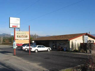
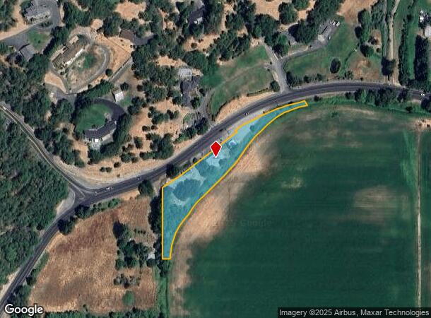
Property Record
4203 Upper River Rd, Grants Pass, OR 97526
Property Detail
4203 Upper River Rd
R318435
ACRES 2.00
Commercialnec
Josephine
AE
Oregon
41033C0484E
2 AC
2024
Medford/Grants Pass
2025
Other Market Areas
360800
Grants Pass, OR
1,888 SF
NEARBY LISTINGS FOR SALE OR LEASE
-
-
View all Grants Pass listings for sale on LoopNet.com
DEMOGRAPHICS near 4203 Upper River Rd
1 mile
3 mile
5 mile
2024 Total Population
1,004
19,301
54,596
2029 Population
1,000
19,378
54,596
Pop Growth 2024-2029
(0.40%)
+ 0.40%
0.00%
Average Age
49
46
45
2024 Total Households
416
7,948
22,151
HH Growth 2024-2029
(0.48%)
+ 0.42%
0.00%
Median Household Inc
$57,692
$47,721
$49,143
Avg Household Size
2.30
2.40
2.40
2024 Avg HH Vehicles
2.00
2.00
2.00
Median Home Value
$454,477
$346,397
$363,465
Median Year Built
1983
1989
1981
Nearby Places
Map Layers
Map Styles
 Street
 Aerial
Transit
 Traffic
 Biking
Places
Listings with unknown addresses are not visible on the map
- Restaurants
- Banks
- Shops
- Fitness
- Groceries
PUBLIC TRANSPORTATION
AIRPORT
Rogue Valley International - Medford
Drive
Walk
Distance
Rogue Valley International - Medford
43 min
30.6 mi
Freight Ports
Port of Coos Bay, OR
Drive
Walk
Distance
Port of Coos Bay, OR
191 min
140.9 mi
Nearby Properties
Address
Land Use
TOTAL SIZE
Lot Size
Zoning
Address
Land Use
TOTAL SIZE
Lot Size
Zoning
1,324,134 SF
9.03 AC
R-1-6
Address
Land Use
TOTAL SIZE
Lot Size
Zoning
41,944 SF
7.80 AC
R-3
Address
Land Use
TOTAL SIZE
Lot Size
Zoning
498 SF
40.34 AC
R-3
Address
Land Use
TOTAL SIZE
Lot Size
Zoning
3.56 AC
GC
Address
Land Use
TOTAL SIZE
Lot Size
Zoning
112,259 SF
6.40 AC
GC
Address
Land Use
TOTAL SIZE
Lot Size
Zoning
26,000 SF
9.12 AC
R-1-8
Address
Land Use
TOTAL SIZE
Lot Size
Zoning
4,363 SF
15.58 AC
GC
Address
Land Use
TOTAL SIZE
Lot Size
Zoning
59,641 SF
4.99 AC
GC
Address
Land Use
TOTAL SIZE
Lot Size
Zoning
52,746 SF
14.66 AC
R-1-8
Address
Land Use
TOTAL SIZE
Lot Size
Zoning
30,823 SF
2.69 AC
GC
Address
Land Use
TOTAL SIZE
Lot Size
Zoning
9.25 AC
GC
Address
Land Use
TOTAL SIZE
Lot Size
Zoning
5,710 SF
28.69 AC
R-1-8
Address
Land Use
TOTAL SIZE
Lot Size
Zoning
2.42 AC
R-1-12
Address
Land Use
TOTAL SIZE
Lot Size
Zoning
39,998 SF
1.70 AC
GC
Address
Land Use
TOTAL SIZE
Lot Size
Zoning
1.49 AC
GC
Address
Land Use
TOTAL SIZE
Lot Size
Zoning
22,000 SF
5.88 AC
BP
Address
Land Use
TOTAL SIZE
Lot Size
Zoning
2,014 SF
15.49 AC
R-2
Address
Land Use
TOTAL SIZE
Lot Size
Zoning
14,439 SF
2.94 AC
GC
Address
Land Use
TOTAL SIZE
Lot Size
Zoning
19 SF
4.63 AC
R-3
Address
Land Use
TOTAL SIZE
Lot Size
Zoning
25,204 SF
3.45 AC
BP
Address
Land Use
TOTAL SIZE
Lot Size
Zoning
1,440 SF
0.80 AC
R-3
Address
Land Use
TOTAL SIZE
Lot Size
Zoning
23,248 SF
3.42 AC
GC
Address
Land Use
TOTAL SIZE
Lot Size
Zoning
41,670 SF
1.65 AC
R-3
Address
Land Use
TOTAL SIZE
Lot Size
Zoning
17,664 SF
2.29 AC
BP
Address
Land Use
TOTAL SIZE
Lot Size
Zoning
1,564 SF
10.50 AC
R-3
Address
Land Use
TOTAL SIZE
Lot Size
Zoning
8,000 SF
4.20 AC
C-5
Address
Land Use
TOTAL SIZE
Lot Size
Zoning
1,600 SF
6.63 AC
BP
Address
Land Use
TOTAL SIZE
Lot Size
Zoning
1,176 SF
12.17 AC
R-2
Address
Land Use
TOTAL SIZE
Lot Size
Zoning
2,237 SF
10.18 AC
R-3
Address
Land Use
TOTAL SIZE
Lot Size
Zoning
4,324 SF
18.28 AC
FR
The World's #1 Commercial Real Estate Marketplace
Connect with us
© 2026 CoStar Group
The information above has been obtained from sources believed reliable. While we do not doubt its accuracy we have not verified it and make no guarantee, warranty or representation about it. It is your responsibility to independently confirm its accuracy and completeness. Any projections, opinions, assumptions, or estimates used are for example only and do not represent the current or future performance of the property. The value of this transaction to you depends on tax and other factors which should be evaluated by your tax, financial, and legal advisors. You and your advisors should conduct a careful, independent investigation of the property to determine to your satisfaction the suitability of the property for your needs.