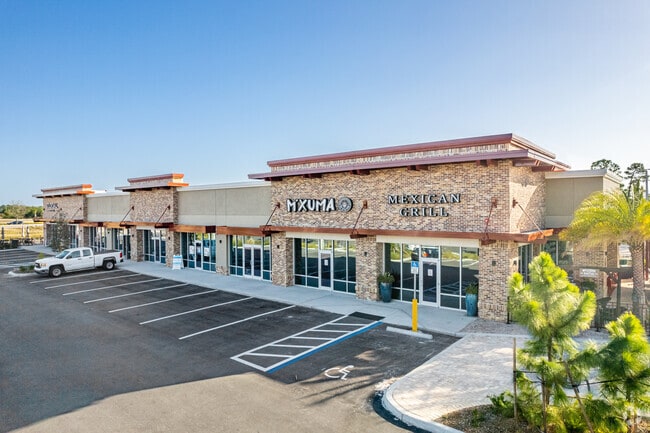
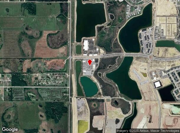
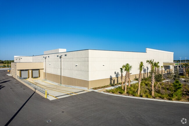
Property Record
42031 Cypress Pkwy, Punta Gorda, FL 33982
NEARBY LISTINGS FOR SALE OR LEASE
-
-
-
-
B Street Babcock Ranch Dr @ Curry Preserve Drive
Punta Gorda, FL 33982
Negotiable
1,200 - 23,000 SF
Retail
-
View all Punta Gorda listings for sale on LoopNet.com
Property Detail
42031 Cypress Pkwy
Punta Gorda, FL
Babcock Ranch Community Cypress Parkway
422631100002
BABCOCK RANCH COMMUNITY CYPRESS PARKWAY TRACT T6 12.96 AC M/L E1791/239 OOT1826/995 FJ1856/9 AGMT1941/20 RES2680/1365 3010/105 E4034/996 E4449/1751 4474/735 E4613/2136 E4613/2116 E4706/1290 E4706/1302 E4706/1321 E4709/94 (564721
Regionalshoppingcenterormallwithanchorstore
Charlotte
2024
Florida
2025
12.96 AC
010100
Charlotte County
87,530 SF
Southwest Florida
DEMOGRAPHICS near 42031 Cypress Pkwy
1 Mile
3 Mile
5 Mile
2024 Total Population
673
5,329
15,103
2029 Population
849
6,628
18,090
Pop Growth 2024-2029
+ 26.15%
+ 24.38%
+ 19.78%
Average Age
46
46
44
2024 Total Households
272
2,098
5,951
HH Growth 2024-2029
+ 26.47%
+ 24.83%
+ 19.71%
Median Household Inc
$89,772
$90,193
$70,095
Avg Household Size
2.40
2.40
2.40
2024 Avg HH Vehicles
2.00
2.00
2.00
Median Home Value
$361,841
$368,715
$303,079
Median Year Built
2010
2009
1985
Nearby Places
Map Layers
Map Styles
 Street
 Aerial
- Restaurants
- Banks
- Shops
- Fitness
- Groceries
PUBLIC TRANSPORTATION
AIRPORT
Southwest Florida International
DRIVE
WALK
Distance
Southwest Florida International
31 min
20.8 mi
Punta Gorda
DRIVE
WALK
Distance
Punta Gorda
35 min
26.2 mi
Freight Ports
Port Manatee
DRIVE
WALK
Distance
Port Manatee
115 min
97.9 mi
Nearby Properties
Address
Land Use
TOTAL SIZE
Lot Size
Zoning
Address
Land Use
TOTAL SIZE
Lot Size
Zoning
367,053 SF
17 AC
BOZD
Address
Land Use
TOTAL SIZE
Lot Size
Zoning
9,424 SF
6,734.78 AC
BOZD
Address
Land Use
TOTAL SIZE
Lot Size
Zoning
309.30 AC
MPD
Address
Land Use
TOTAL SIZE
Lot Size
Zoning
74,698 SF
8.33 AC
BOZD
Address
Land Use
TOTAL SIZE
Lot Size
Zoning
40,490 SF
1.95 AC
BOZD
Address
Land Use
TOTAL SIZE
Lot Size
Zoning
10,304 SF
141.77 AC
BOZD
Address
Land Use
TOTAL SIZE
Lot Size
Zoning
16.06 AC
BOZD
Address
Land Use
TOTAL SIZE
Lot Size
Zoning
18,224 SF
3.56 AC
BOZD
Address
Land Use
TOTAL SIZE
Lot Size
Zoning
11,223 SF
1.15 AC
BOZD
Address
Land Use
TOTAL SIZE
Lot Size
Zoning
85.73 AC
MPD
Address
Land Use
TOTAL SIZE
Lot Size
Zoning
31,657 SF
7.91 AC
BOZD
Address
Land Use
TOTAL SIZE
Lot Size
Zoning
116,525 SF
10 AC
BOZD
Address
Land Use
TOTAL SIZE
Lot Size
Zoning
49,980 SF
159.94 AC
II
Address
Land Use
TOTAL SIZE
Lot Size
Zoning
9,017 SF
1.86 AC
CR
Address
Land Use
TOTAL SIZE
Lot Size
Zoning
1,600 SF
477 AC
ES
Address
Land Use
TOTAL SIZE
Lot Size
Zoning
10,725 SF
80 AC
AG
Address
Land Use
TOTAL SIZE
Lot Size
Zoning
6,030 SF
0.24 AC
BOZD
Address
Land Use
TOTAL SIZE
Lot Size
Zoning
702 SF
6.42 AC
BOZD
Address
Land Use
TOTAL SIZE
Lot Size
Zoning
5,547 SF
0.30 AC
BOZD
Address
Land Use
TOTAL SIZE
Lot Size
Zoning
185.23 AC
MPD
Address
Land Use
TOTAL SIZE
Lot Size
Zoning
19,421 SF
7.11 AC
AG-2
Address
Land Use
TOTAL SIZE
Lot Size
Zoning
6,936 SF
154.71 AC
BOZD
Address
Land Use
TOTAL SIZE
Lot Size
Zoning
12,524 SF
33.01 AC
BOZD
Address
Land Use
TOTAL SIZE
Lot Size
Zoning
61.85 AC
BOZD
Address
Land Use
TOTAL SIZE
Lot Size
Zoning
10,604 SF
79.30 AC
AG-2
Address
Land Use
TOTAL SIZE
Lot Size
Zoning
1.98 AC
BOZD
Address
Land Use
TOTAL SIZE
Lot Size
Zoning
17,581 SF
5 AC
IG
Address
Land Use
TOTAL SIZE
Lot Size
Zoning
1,260 SF
5 AC
IG
Address
Land Use
TOTAL SIZE
Lot Size
Zoning
5,054 SF
0.23 AC
BOZD
The World's #1 Commercial Real Estate Marketplace
Connect with us
© 2026 CoStar Group
The information above has been obtained from sources believed reliable. While we do not doubt its accuracy we have not verified it and make no guarantee, warranty or representation about it. It is your responsibility to independently confirm its accuracy and completeness. Any projections, opinions, assumptions, or estimates used are for example only and do not represent the current or future performance of the property. The value of this transaction to you depends on tax and other factors which should be evaluated by your tax, financial, and legal advisors. You and your advisors should conduct a careful, independent investigation of the property to determine to your satisfaction the suitability of the property for your needs.