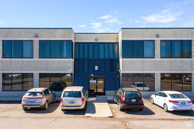
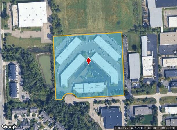
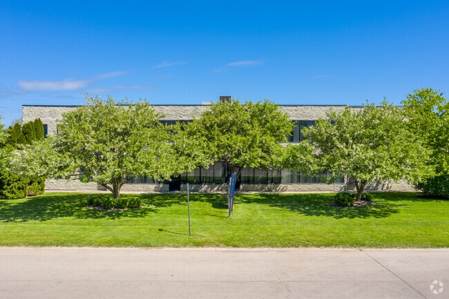
Property Record
42000 Koppernick Rd, Canton, MI 48187
NEARBY LISTINGS FOR SALE OR LEASE
-
-
View all Canton listings for lease on LoopNet.com
Property Detail
42000 Koppernick Rd
71-008-99-0001-021
Mayfair Village
Industrialgeneral
02Q1G1 PT OF SE 1/4 SEC 2 T2S R8E DESC AS BEG S00DEG 33M 13S E 1322.66FT AND S88DEG 41M 26S W 1381.33FT FROM E 1/4 COR SEC 2
AE
Wayne
26163C0204E
Michigan
2024
9.88 AC
2025
Southern I-275
563300
Detroit
132,171 SF
Detroit-Warren-Dearborn, MI
DEMOGRAPHICS near 42000 Koppernick Rd
1 Mile
3 Mile
5 Mile
2024 Total Population
8,481
85,543
201,293
2029 Population
8,043
81,975
193,139
Pop Growth 2024-2029
(5.16%)
(4.17%)
(4.05%)
Average Age
42
41
42
2024 Total Households
3,487
35,469
82,356
HH Growth 2024-2029
(5.13%)
(4.18%)
(4.00%)
Median Household Inc
$91,527
$90,718
$90,031
Avg Household Size
2.40
2.40
2.40
2024 Avg HH Vehicles
2.00
2.00
2.00
Median Home Value
$257,025
$278,172
$272,549
Median Year Built
1976
1976
1977
Nearby Places
- Restaurants
- Banks
- Shops
- Fitness
- Groceries
PUBLIC TRANSPORTATION
AIRPORT
Detroit Metro Wayne County
DRIVE
WALK
Distance
Detroit Metro Wayne County
22 min
15.6 mi
Windsor International
DRIVE
WALK
Distance
Windsor International
56 min
35.9 mi
Freight Ports
Port of Toledo
DRIVE
WALK
Distance
Port of Toledo
72 min
57.3 mi
SALE & LEASE HISTORY
LISTING DATE
SALE/LEASE

Sep 25, 2016
For Lease
May 22, 2017
For Lease
Nearby Properties
Address
Land Use
TOTAL SIZE
Lot Size
Zoning
Address
Land Use
TOTAL SIZE
Lot Size
Zoning
1,005,040 SF
Address
Land Use
TOTAL SIZE
Lot Size
Zoning
400,857 SF
27.44 AC
RP
Address
Land Use
TOTAL SIZE
Lot Size
Zoning
37.30 AC
MR
Address
Land Use
TOTAL SIZE
Lot Size
Zoning
517,265 SF
116.72 AC
Address
Land Use
TOTAL SIZE
Lot Size
Zoning
176,796 SF
17.08 AC
C-2
Address
Land Use
TOTAL SIZE
Lot Size
Zoning
167,491 SF
18.59 AC
Address
Land Use
TOTAL SIZE
Lot Size
Zoning
408,122 SF
23.31 AC
MR
Address
Land Use
TOTAL SIZE
Lot Size
Zoning
21.71 AC
MR
Address
Land Use
TOTAL SIZE
Lot Size
Zoning
311,556 SF
23.17 AC
C-3
Address
Land Use
TOTAL SIZE
Lot Size
Zoning
114,894 SF
4.94 AC
ARC
Address
Land Use
TOTAL SIZE
Lot Size
Zoning
352,514 SF
26.40 AC
Address
Land Use
TOTAL SIZE
Lot Size
Zoning
24.63 AC
MR
Address
Land Use
TOTAL SIZE
Lot Size
Zoning
20.91 AC
Address
Land Use
TOTAL SIZE
Lot Size
Zoning
361,807 SF
18.77 AC
M-2
Address
Land Use
TOTAL SIZE
Lot Size
Zoning
225,164 SF
25.66 AC
IND
Address
Land Use
TOTAL SIZE
Lot Size
Zoning
169,489 SF
14.51 AC
R-6
Address
Land Use
TOTAL SIZE
Lot Size
Zoning
283,710 SF
IND
Address
Land Use
TOTAL SIZE
Lot Size
Zoning
221,508 SF
26.03 AC
IND
Address
Land Use
TOTAL SIZE
Lot Size
Zoning
113,292 SF
15.79 AC
IND
Address
Land Use
TOTAL SIZE
Lot Size
Zoning
123,225 SF
9 AC
CJ/ARC
Address
Land Use
TOTAL SIZE
Lot Size
Zoning
Address
Land Use
TOTAL SIZE
Lot Size
Zoning
954,882 SF
47.92 AC
LI-2
Address
Land Use
TOTAL SIZE
Lot Size
Zoning
169,968 SF
12.46 AC
MR
Address
Land Use
TOTAL SIZE
Lot Size
Zoning
249,795 SF
21.17 AC
Address
Land Use
TOTAL SIZE
Lot Size
Zoning
186,967 SF
9.75 AC
Address
Land Use
TOTAL SIZE
Lot Size
Zoning
11.40 AC
MR
Address
Land Use
TOTAL SIZE
Lot Size
Zoning
172,094 SF
11.84 AC
M-2
Address
Land Use
TOTAL SIZE
Lot Size
Zoning
16.03 AC
MR
Address
Land Use
TOTAL SIZE
Lot Size
Zoning
147,968 SF
16.68 AC
Address
Land Use
TOTAL SIZE
Lot Size
Zoning
66,670 SF
11.20 AC
C-3
The World's #1 Commercial Real Estate Marketplace
Connect with us
© 2025 CoStar Group
The information above has been obtained from sources believed reliable. While we do not doubt its accuracy we have not verified it and make no guarantee, warranty or representation about it. It is your responsibility to independently confirm its accuracy and completeness. Any projections, opinions, assumptions, or estimates used are for example only and do not represent the current or future performance of the property. The value of this transaction to you depends on tax and other factors which should be evaluated by your tax, financial, and legal advisors. You and your advisors should conduct a careful, independent investigation of the property to determine to your satisfaction the suitability of the property for your needs.