Property Record
4205 W Columbia Rd, Mason, MI 48854

NEARBY LISTINGS FOR SALE OR LEASE
-
-
View all Mason listings for lease on LoopNet.com
Property Detail
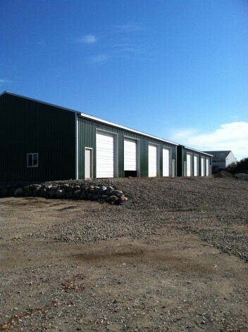
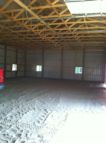
4205 W Columbia Rd
09-09-11-200-009
BEG AT N 1/4 COR OF SEC 11 -N89D 48' 10E ALNG N SEC LN 146.85 FT -S00D 11' 50"E 275 FT -N89D 48' 10"E 165 FT -N00D 11' 50"W
Agriculturalland
Ingham
X
Michigan
26065C0235D
10.83 AC
2024
Mason/SE Ingham County
2025
West Michigan
006401
Lansing-East Lansing, MI
DEMOGRAPHICS near 4205 W Columbia Rd
1 Mile
3 Mile
5 Mile
2024 Total Population
1,047
6,906
30,450
2029 Population
1,030
6,793
30,120
Pop Growth 2024-2029
(1.62%)
(1.64%)
(1.08%)
Average Age
39
40
41
2024 Total Households
370
2,706
12,521
HH Growth 2024-2029
(1.89%)
(1.74%)
(1.06%)
Median Household Inc
$90,582
$81,020
$72,059
Avg Household Size
2.90
2.50
2.40
2024 Avg HH Vehicles
2.00
2.00
2.00
Median Home Value
$224,691
$185,399
$175,758
Median Year Built
1993
1986
1978
Nearby Places
Map Layers
Map Styles
 Street
 Aerial
- Restaurants
- Banks
- Shops
- Fitness
- Groceries
PUBLIC TRANSPORTATION
AIRPORT
Capital Region International
DRIVE
WALK
Distance
Capital Region International
28 min
15.9 mi
Freight Ports
Port of Toledo
DRIVE
WALK
Distance
Port of Toledo
137 min
105.8 mi
SALE & LEASE HISTORY
LISTING DATE
SALE/LEASE

Oct 18, 2020
For Lease
Nearby Properties
Address
Land Use
TOTAL SIZE
Lot Size
Zoning
Address
Land Use
TOTAL SIZE
Lot Size
Zoning
146,160 SF
88.98 AC
I-1
Address
Land Use
TOTAL SIZE
Lot Size
Zoning
15,000 SF
Address
Land Use
TOTAL SIZE
Lot Size
Zoning
107,580 SF
Address
Land Use
TOTAL SIZE
Lot Size
Zoning
269,915 SF
Address
Land Use
TOTAL SIZE
Lot Size
Zoning
137,084 SF
6.86 AC
M1
Address
Land Use
TOTAL SIZE
Lot Size
Zoning
55.34 AC
MH
Address
Land Use
TOTAL SIZE
Lot Size
Zoning
Address
Land Use
TOTAL SIZE
Lot Size
Zoning
6,768 SF
228.81 AC
A-1
Address
Land Use
TOTAL SIZE
Lot Size
Zoning
216 SF
6.17 AC
RM
Address
Land Use
TOTAL SIZE
Lot Size
Zoning
31.63 AC
MH
Address
Land Use
TOTAL SIZE
Lot Size
Zoning
64,640 SF
3.42 AC
M1
Address
Land Use
TOTAL SIZE
Lot Size
Zoning
42,954 SF
3.11 AC
C2
Address
Land Use
TOTAL SIZE
Lot Size
Zoning
8,288 SF
2.72 AC
RM
Address
Land Use
TOTAL SIZE
Lot Size
Zoning
6,768 SF
228.53 AC
Address
Land Use
TOTAL SIZE
Lot Size
Zoning
39,176 SF
4.96 AC
C2
Address
Land Use
TOTAL SIZE
Lot Size
Zoning
3,840 SF
7.67 AC
A-1
Address
Land Use
TOTAL SIZE
Lot Size
Zoning
31,172 SF
10.11 AC
M2
Address
Land Use
TOTAL SIZE
Lot Size
Zoning
16,000 SF
6.63 AC
C-3
Address
Land Use
TOTAL SIZE
Lot Size
Zoning
15,484 SF
2.45 AC
B-2
Address
Land Use
TOTAL SIZE
Lot Size
Zoning
3,873 SF
5.53 AC
M1
Address
Land Use
TOTAL SIZE
Lot Size
Zoning
19,157 SF
1.48 AC
C2
Address
Land Use
TOTAL SIZE
Lot Size
Zoning
600 SF
7.42 AC
B-1
Address
Land Use
TOTAL SIZE
Lot Size
Zoning
300,000 SF
Address
Land Use
TOTAL SIZE
Lot Size
Zoning
34,390 SF
2.38 AC
C2
Address
Land Use
TOTAL SIZE
Lot Size
Zoning
56,417 SF
9.60 AC
IM
Address
Land Use
TOTAL SIZE
Lot Size
Zoning
21,400 SF
4.07 AC
M2
Address
Land Use
TOTAL SIZE
Lot Size
Zoning
4,200 SF
3.34 AC
M2
Address
Land Use
TOTAL SIZE
Lot Size
Zoning
2,066 SF
0.92 AC
C2
Address
Land Use
TOTAL SIZE
Lot Size
Zoning
33,930 SF
3.29 AC
IA
Address
Land Use
TOTAL SIZE
Lot Size
Zoning
39,074 SF
The World's #1 Commercial Real Estate Marketplace
Connect with us
© 2025 CoStar Group
The information above has been obtained from sources believed reliable. While we do not doubt its accuracy we have not verified it and make no guarantee, warranty or representation about it. It is your responsibility to independently confirm its accuracy and completeness. Any projections, opinions, assumptions, or estimates used are for example only and do not represent the current or future performance of the property. The value of this transaction to you depends on tax and other factors which should be evaluated by your tax, financial, and legal advisors. You and your advisors should conduct a careful, independent investigation of the property to determine to your satisfaction the suitability of the property for your needs.