Property Record
4209 E Sh 71 E, Bastrop, TX 78602

Property Detail
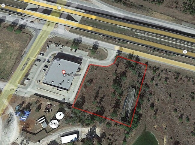
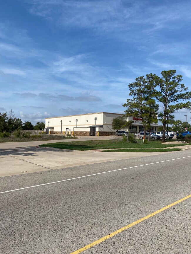
4209 E Sh 71 E
Austin-Round Rock-San Marcos, TX
TAHITIAN VILLAGE, UNIT 1, LOT 3, ACRES 1.424, (SUBDIVISION OF A PORTION OF CLUB HOUSE AREA)
105103
BASTROP
Residentialacreage
Texas
B and X Area of moderate flood hazard, usually the area between the limits of the 100-year and 500-year floods.
3
2024
1.42 AC
2025
Bastrop County
950401
Austin
NEARBY LISTINGS FOR SALE OR LEASE
DEMOGRAPHICS near 4209 E Sh 71 E
1 mile
3 mile
5 mile
2025 Total Population
2,107
14,457
26,878
2030 Population
2,427
16,676
30,886
Pop Growth 2025-2030
+ 15.19%
+ 15.35%
+ 14.91%
Average Age
41
41
41
2025 Total Households
871
5,707
10,222
HH Growth 2025-2030
+ 15.61%
+ 15.86%
+ 15.52%
Median Household Inc
$84,817
$79,965
$80,673
Avg Household Size
2.40
2.40
2.50
2025 Avg HH Vehicles
2.00
2.00
2.00
Median Home Value
$362,623
$360,275
$349,093
Median Year Built
2003
2004
2004
Nearby Places
Map Layers
Map Styles
 Street
 Aerial
Transit
 Traffic
 Biking
Places
Listings with unknown addresses are not visible on the map
- Restaurants
- Banks
- Shops
- Fitness
- Groceries
PUBLIC TRANSPORTATION
AIRPORT
Austin-Bergstrom International
Drive
Walk
Distance
Austin-Bergstrom International
41 min
28.5 mi
SALE & LEASE HISTORY
LISTING DATE
SALE/LEASE

Aug 25, 2022
For Sale
Nearby Properties
Address
Land Use
TOTAL SIZE
Lot Size
Zoning
Address
Land Use
TOTAL SIZE
Lot Size
Zoning
140,496 SF
8.05 AC
Address
Land Use
TOTAL SIZE
Lot Size
Zoning
140,878 SF
8.31 AC
Address
Land Use
TOTAL SIZE
Lot Size
Zoning
180,568 SF
23.98 AC
Address
Land Use
TOTAL SIZE
Lot Size
Zoning
105,020 SF
13.43 AC
Address
Land Use
TOTAL SIZE
Lot Size
Zoning
65,206 SF
2.55 AC
Address
Land Use
TOTAL SIZE
Lot Size
Zoning
169,350 SF
25.30 AC
Address
Land Use
TOTAL SIZE
Lot Size
Zoning
173,350 SF
10.58 AC
Address
Land Use
TOTAL SIZE
Lot Size
Zoning
69,508 SF
4.10 AC
Address
Land Use
TOTAL SIZE
Lot Size
Zoning
47,126 SF
3.33 AC
Address
Land Use
TOTAL SIZE
Lot Size
Zoning
62,734 SF
2.55 AC
Address
Land Use
TOTAL SIZE
Lot Size
Zoning
27,936 SF
5 AC
Address
Land Use
TOTAL SIZE
Lot Size
Zoning
53,318 SF
5.36 AC
Address
Land Use
TOTAL SIZE
Lot Size
Zoning
44,692 SF
2.75 AC
Address
Land Use
TOTAL SIZE
Lot Size
Zoning
17,869 SF
7.71 AC
Address
Land Use
TOTAL SIZE
Lot Size
Zoning
21,610 SF
281.75 AC
Address
Land Use
TOTAL SIZE
Lot Size
Zoning
33,628 SF
3.74 AC
Address
Land Use
TOTAL SIZE
Lot Size
Zoning
28,022 SF
9.19 AC
Address
Land Use
TOTAL SIZE
Lot Size
Zoning
59,561 SF
4.57 AC
Address
Land Use
TOTAL SIZE
Lot Size
Zoning
1,680 SF
43.63 AC
Address
Land Use
TOTAL SIZE
Lot Size
Zoning
31,002 SF
1.56 AC
Address
Land Use
TOTAL SIZE
Lot Size
Zoning
52,188 SF
2.88 AC
Address
Land Use
TOTAL SIZE
Lot Size
Zoning
63,545 SF
15.73 AC
Address
Land Use
TOTAL SIZE
Lot Size
Zoning
13,558 SF
0.94 AC
Address
Land Use
TOTAL SIZE
Lot Size
Zoning
40,102 SF
3.55 AC
Address
Land Use
TOTAL SIZE
Lot Size
Zoning
28,855 SF
2.55 AC
Address
Land Use
TOTAL SIZE
Lot Size
Zoning
58,728 SF
11.39 AC
Address
Land Use
TOTAL SIZE
Lot Size
Zoning
59,471 SF
5.85 AC
Address
Land Use
TOTAL SIZE
Lot Size
Zoning
15,827 SF
1.87 AC
The World's #1 Commercial Real Estate Marketplace
Connect with us
© 2026 CoStar Group
The information above has been obtained from sources believed reliable. While we do not doubt its accuracy we have not verified it and make no guarantee, warranty or representation about it. It is your responsibility to independently confirm its accuracy and completeness. Any projections, opinions, assumptions, or estimates used are for example only and do not represent the current or future performance of the property. The value of this transaction to you depends on tax and other factors which should be evaluated by your tax, financial, and legal advisors. You and your advisors should conduct a careful, independent investigation of the property to determine to your satisfaction the suitability of the property for your needs.