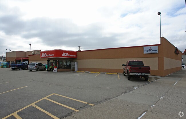
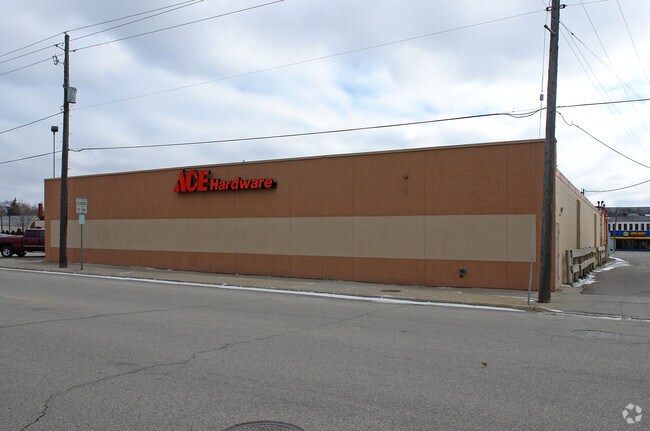
Property Record
421 2Nd Ave Nw, Faribault, MN 55021

Save to a Folder
{{folder.Name}}
{{folder.ListingIds.length}} Properties
{{folder.ListingIds.length}} Property
Create a New Folder
Property Detail
421 2Nd Ave Nw
18.31.1.26.204
LOT 3 BLOCK 35 OF ORIGINAL TOWN FARIBAULT ORIG TOWN L3-4 & L5 B35 EX E2FT L3 B35
Storebuilding
Rice
B and X Area of moderate flood hazard, usually the area between the limits of the 100-year and 500-year floods.
Minnesota
2026
3
2026
0.74 AC
070702
Other Market Areas
17,293 SF
Faribault-Northfield, MN
NEARBY LISTINGS FOR SALE OR LEASE
DEMOGRAPHICS near 421 2Nd Ave Nw
1 mile
3 mile
5 mile
2025 Total Population
9,273
25,739
27,905
2030 Population
9,445
26,258
28,501
Pop Growth 2025-2030
+ 1.85%
+ 2.02%
+ 2.14%
Average Age
39
39
40
2025 Total Households
3,403
9,094
9,964
HH Growth 2025-2030
+ 2.15%
+ 2.23%
+ 2.38%
Median Household Inc
$48,854
$57,607
$61,462
Avg Household Size
2.40
2.50
2.50
2025 Avg HH Vehicles
2.00
2.00
2.00
Median Home Value
$205,299
$242,679
$254,242
Median Year Built
1960
1973
1974
Nearby Places
Map Layers
Map Styles
 Street
 Aerial
Layers
 Traffic
 Biking
Places
Listings with unknown addresses are not visible on the map
- Restaurants
- Banks
- Shops
- Fitness
- Groceries
Nearby Properties
Address
Land Use
TOTAL SIZE
Lot Size
Zoning
Address
Land Use
TOTAL SIZE
Lot Size
Zoning
85,904 SF
131 AC
Address
Land Use
TOTAL SIZE
Lot Size
Zoning
334,226 SF
44.17 AC
Address
Land Use
TOTAL SIZE
Lot Size
Zoning
130,872 SF
11.59 AC
Address
Land Use
TOTAL SIZE
Lot Size
Zoning
19,800 SF
40.71 AC
Address
Land Use
TOTAL SIZE
Lot Size
Zoning
59,322 SF
28 AC
Address
Land Use
TOTAL SIZE
Lot Size
Zoning
287,239 SF
26.50 AC
Address
Land Use
TOTAL SIZE
Lot Size
Zoning
187,983 SF
73.90 AC
Address
Land Use
TOTAL SIZE
Lot Size
Zoning
320,000 SF
20.04 AC
Address
Land Use
TOTAL SIZE
Lot Size
Zoning
94,471 SF
27.70 AC
Address
Land Use
TOTAL SIZE
Lot Size
Zoning
122,064 SF
2.87 AC
Address
Land Use
TOTAL SIZE
Lot Size
Zoning
14,726 SF
19.50 AC
Address
Land Use
TOTAL SIZE
Lot Size
Zoning
86,334 SF
34.30 AC
Address
Land Use
TOTAL SIZE
Lot Size
Zoning
104,074 SF
3.50 AC
Address
Land Use
TOTAL SIZE
Lot Size
Zoning
41,174 SF
2.79 AC
Address
Land Use
TOTAL SIZE
Lot Size
Zoning
78,705 SF
7.40 AC
Address
Land Use
TOTAL SIZE
Lot Size
Zoning
1,948 SF
7.95 AC
Address
Land Use
TOTAL SIZE
Lot Size
Zoning
228,532 SF
16.73 AC
Address
Land Use
TOTAL SIZE
Lot Size
Zoning
59,468 SF
29 AC
Address
Land Use
TOTAL SIZE
Lot Size
Zoning
305,145 SF
17.32 AC
Address
Land Use
TOTAL SIZE
Lot Size
Zoning
89,616 SF
4.58 AC
Address
Land Use
TOTAL SIZE
Lot Size
Zoning
97,588 SF
1.93 AC
Address
Land Use
TOTAL SIZE
Lot Size
Zoning
92,888 SF
2.11 AC
Address
Land Use
TOTAL SIZE
Lot Size
Zoning
77,282 SF
3.60 AC
Address
Land Use
TOTAL SIZE
Lot Size
Zoning
77,282 SF
5.10 AC
Address
Land Use
TOTAL SIZE
Lot Size
Zoning
82,651 SF
23.67 AC
Address
Land Use
TOTAL SIZE
Lot Size
Zoning
49,703 SF
4.03 AC
Address
Land Use
TOTAL SIZE
Lot Size
Zoning
26,866 SF
2.80 AC
Address
Land Use
TOTAL SIZE
Lot Size
Zoning
69,209 SF
36.05 AC
Address
Land Use
TOTAL SIZE
Lot Size
Zoning
83,289 SF
1.60 AC
Address
Land Use
TOTAL SIZE
Lot Size
Zoning
63,394 SF
3.60 AC
The World's #1 Commercial Real Estate Marketplace
Connect with us
© 2026 CoStar Group
The information above has been obtained from sources believed reliable. While we do not doubt its accuracy we have not verified it and make no guarantee, warranty or representation about it. It is your responsibility to independently confirm its accuracy and completeness. Any projections, opinions, assumptions, or estimates used are for example only and do not represent the current or future performance of the property. The value of this transaction to you depends on tax and other factors which should be evaluated by your tax, financial, and legal advisors. You and your advisors should conduct a careful, independent investigation of the property to determine to your satisfaction the suitability of the property for your needs.