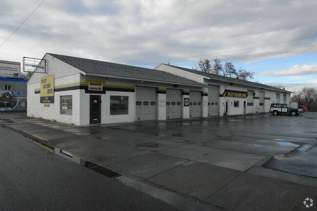
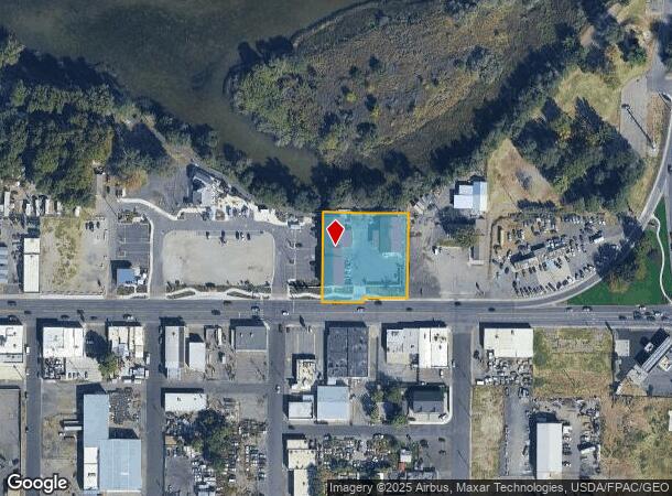
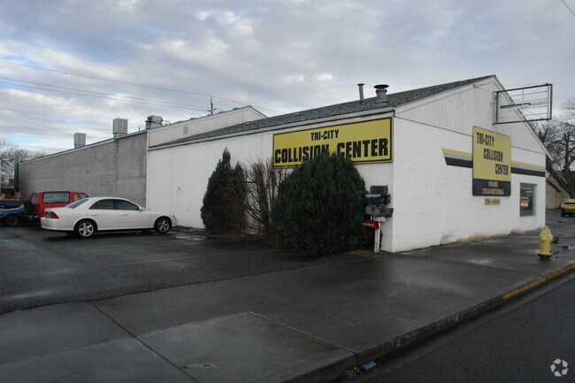
Property Record
421 E Columbia Dr, Kennewick, WA 99336
NEARBY LISTINGS FOR SALE OR LEASE
Property Detail
421 E Columbia Dr
Other Market Areas
Replat Of Columbia Gardens
Kennewick-Richland, WA
SECTION 31, TOWNSHIP 9 NORTH, RANGE 30 EAST, QUARTER SW: THE WEST 90 FEET OF LOT 16 AND THE SOUTH 20 FEET OF THAT PORTION OF TRACT 7, LYING EAST OF THE NORTHERLY EXTENSION OF THE EAST LINE OF THE WEST 90 FEET OF SAID LOT 16, REPLAT OF COLUMBIA GARDEN
131903030016002
Benton
Industrialgeneral
Washington
2024
16
2024
1.04 AC
011300
Yakima/Kennewick
12,288 SF
DEMOGRAPHICS near 421 E Columbia Dr
1 Mile
3 Mile
5 Mile
2024 Total Population
5,329
79,822
138,940
2029 Population
5,720
86,020
149,621
Pop Growth 2024-2029
+ 7.34%
+ 7.76%
+ 7.69%
Average Age
36
35
36
2024 Total Households
1,878
25,885
46,300
HH Growth 2024-2029
+ 7.35%
+ 7.77%
+ 7.70%
Median Household Inc
$49,939
$58,062
$68,770
Avg Household Size
2.70
3.00
2.90
2024 Avg HH Vehicles
2.00
2.00
2.00
Median Home Value
$180,539
$249,662
$304,959
Median Year Built
1957
1971
1977
Nearby Places
Map Layers
Map Styles
 Street
 Aerial
- Restaurants
- Banks
- Shops
- Fitness
- Groceries
PUBLIC TRANSPORTATION
COMMUTER RAIL
Pasco Amtrak Station (Empire Builder - Amtrak)
DRIVE
WALK
Distance
Pasco Amtrak Station (Empire Builder - Amtrak)
6 min
2.5 mi
AIRPORT
Tri-Cities
DRIVE
WALK
Distance
Tri-Cities
10 min
5.2 mi
Freight Ports
Port of Tacoma
DRIVE
WALK
Distance
Port of Tacoma
273 min
237.5 mi
Nearby Properties
Address
Land Use
TOTAL SIZE
Lot Size
Zoning
Address
Land Use
TOTAL SIZE
Lot Size
Zoning
1,049,518 SF
104.40 AC
Address
Land Use
TOTAL SIZE
Lot Size
Zoning
2,863,808 SF
28.33 AC
Address
Land Use
TOTAL SIZE
Lot Size
Zoning
294,855 SF
35.04 AC
KENNEWICK
Address
Land Use
TOTAL SIZE
Lot Size
Zoning
377,541 SF
24.58 AC
Address
Land Use
TOTAL SIZE
Lot Size
Zoning
153,320 SF
7.37 AC
Address
Land Use
TOTAL SIZE
Lot Size
Zoning
113,585 SF
15.43 AC
Address
Land Use
TOTAL SIZE
Lot Size
Zoning
114,673 SF
6.58 AC
Address
Land Use
TOTAL SIZE
Lot Size
Zoning
84,951 SF
4.39 AC
Address
Land Use
TOTAL SIZE
Lot Size
Zoning
172,573 SF
15.30 AC
Address
Land Use
TOTAL SIZE
Lot Size
Zoning
84,680 SF
3 AC
Address
Land Use
TOTAL SIZE
Lot Size
Zoning
61,400 SF
11.50 AC
Address
Land Use
TOTAL SIZE
Lot Size
Zoning
164,172 SF
9.37 AC
35
Address
Land Use
TOTAL SIZE
Lot Size
Zoning
67,635 SF
5.95 AC
Address
Land Use
TOTAL SIZE
Lot Size
Zoning
149,281 SF
10.79 AC
Address
Land Use
TOTAL SIZE
Lot Size
Zoning
67,748 SF
3.87 AC
Address
Land Use
TOTAL SIZE
Lot Size
Zoning
241,912 SF
12.99 AC
Address
Land Use
TOTAL SIZE
Lot Size
Zoning
110,740 SF
18.15 AC
Address
Land Use
TOTAL SIZE
Lot Size
Zoning
584,810 SF
Address
Land Use
TOTAL SIZE
Lot Size
Zoning
55,809 SF
10.79 AC
Address
Land Use
TOTAL SIZE
Lot Size
Zoning
20,919 SF
58.49 AC
KENNEWICK
Address
Land Use
TOTAL SIZE
Lot Size
Zoning
103,115 SF
8.38 AC
Address
Land Use
TOTAL SIZE
Lot Size
Zoning
47,064 SF
13.70 AC
KENNEWICK
Address
Land Use
TOTAL SIZE
Lot Size
Zoning
80,604 SF
4.30 AC
Address
Land Use
TOTAL SIZE
Lot Size
Zoning
75,542 SF
6.36 AC
Address
Land Use
TOTAL SIZE
Lot Size
Zoning
125,508 SF
3.49 AC
Address
Land Use
TOTAL SIZE
Lot Size
Zoning
114,726 SF
7.59 AC
Address
Land Use
TOTAL SIZE
Lot Size
Zoning
101,720 SF
4.92 AC
33
Address
Land Use
TOTAL SIZE
Lot Size
Zoning
86,712 SF
4.15 AC
Address
Land Use
TOTAL SIZE
Lot Size
Zoning
147,847 SF
8.47 AC
Address
Land Use
TOTAL SIZE
Lot Size
Zoning
33,680 SF
2.60 AC
The World's #1 Commercial Real Estate Marketplace
Connect with us
© 2025 CoStar Group
The information above has been obtained from sources believed reliable. While we do not doubt its accuracy we have not verified it and make no guarantee, warranty or representation about it. It is your responsibility to independently confirm its accuracy and completeness. Any projections, opinions, assumptions, or estimates used are for example only and do not represent the current or future performance of the property. The value of this transaction to you depends on tax and other factors which should be evaluated by your tax, financial, and legal advisors. You and your advisors should conduct a careful, independent investigation of the property to determine to your satisfaction the suitability of the property for your needs.