Property Record
421 Hartman Bridge Rd, Strasburg, PA 17579

NEARBY LISTINGS FOR SALE OR LEASE
-
-
View all Strasburg listings for sale on LoopNet.com
Property Detail
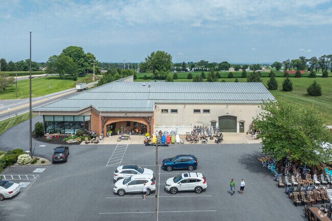
421 Hartman Bridge Rd
Lancaster, PA
Mable M Edwards
580-75359-0-0000
421 HARTMAN BRIDGE RD
Storebuilding
Lancaster
X
Pennsylvania
42071C0535F
1
2024
8.50 AC
2025
Lancaster County
014000
Philadelphia
21,169 SF
DEMOGRAPHICS near 421 Hartman Bridge Rd
1 Mile
3 Mile
5 Mile
2024 Total Population
3,396
9,460
35,528
2029 Population
3,399
9,445
35,486
Pop Growth 2024-2029
+ 0.09%
(0.16%)
(0.12%)
Average Age
40
39
40
2024 Total Households
1,240
3,283
12,765
HH Growth 2024-2029
+ 0.16%
(0.12%)
(0.13%)
Median Household Inc
$82,401
$83,976
$84,974
Avg Household Size
2.70
2.80
2.70
2024 Avg HH Vehicles
2.00
2.00
2.00
Median Home Value
$265,348
$288,882
$305,627
Median Year Built
1970
1970
1980
Nearby Places
Map Layers
Map Styles
 Street
 Aerial
- Restaurants
- Banks
- Shops
- Fitness
- Groceries
PUBLIC TRANSPORTATION
COMMUTER RAIL
DRIVE
WALK
Distance
19 min
9.7 mi
AIRPORT
Harrisburg International
DRIVE
WALK
Distance
Harrisburg International
54 min
40.3 mi
Freight Ports
Port Newark Container Terminal
DRIVE
WALK
Distance
Port Newark Container Terminal
73 min
40.7 mi
Nearby Properties
Address
Land Use
TOTAL SIZE
Lot Size
Zoning
Address
Land Use
TOTAL SIZE
Lot Size
Zoning
333,041 SF
159.39 AC
RV
Address
Land Use
TOTAL SIZE
Lot Size
Zoning
289,398 SF
35.20 AC
C-2
Address
Land Use
TOTAL SIZE
Lot Size
Zoning
221,609 SF
62.37 AC
HC
Address
Land Use
TOTAL SIZE
Lot Size
Zoning
113,272 SF
13.80 AC
RC
Address
Land Use
TOTAL SIZE
Lot Size
Zoning
36,494 SF
7 AC
R-2
Address
Land Use
TOTAL SIZE
Lot Size
Zoning
51,824 SF
2.33 AC
Address
Land Use
TOTAL SIZE
Lot Size
Zoning
123,614 SF
8.99 AC
C-2
Address
Land Use
TOTAL SIZE
Lot Size
Zoning
53,275 SF
5.01 AC
C-2
Address
Land Use
TOTAL SIZE
Lot Size
Zoning
46,926 SF
3.12 AC
Address
Land Use
TOTAL SIZE
Lot Size
Zoning
41,534 SF
1.96 AC
Address
Land Use
TOTAL SIZE
Lot Size
Zoning
47,022 SF
3.28 AC
C-2
Address
Land Use
TOTAL SIZE
Lot Size
Zoning
39,670 SF
5.23 AC
C-2
Address
Land Use
TOTAL SIZE
Lot Size
Zoning
21,185 SF
6.88 AC
C-2
Address
Land Use
TOTAL SIZE
Lot Size
Zoning
56,614 SF
6.20 AC
C-2
Address
Land Use
TOTAL SIZE
Lot Size
Zoning
55,546 SF
9.70 AC
C-2
Address
Land Use
TOTAL SIZE
Lot Size
Zoning
51,450 SF
7.60 AC
C-2
Address
Land Use
TOTAL SIZE
Lot Size
Zoning
44,862 SF
4.30 AC
Address
Land Use
TOTAL SIZE
Lot Size
Zoning
20,436 SF
2.15 AC
Address
Land Use
TOTAL SIZE
Lot Size
Zoning
24,798 SF
6.90 AC
Address
Land Use
TOTAL SIZE
Lot Size
Zoning
40,001 SF
4.20 AC
C-2
Address
Land Use
TOTAL SIZE
Lot Size
Zoning
27,317 SF
1.90 AC
C-2
Address
Land Use
TOTAL SIZE
Lot Size
Zoning
106,553 SF
7.41 AC
C-2
Address
Land Use
TOTAL SIZE
Lot Size
Zoning
12,815 SF
132.60 AC
A
Address
Land Use
TOTAL SIZE
Lot Size
Zoning
6,793 SF
156.70 AC
A
Address
Land Use
TOTAL SIZE
Lot Size
Zoning
2.17 AC
Address
Land Use
TOTAL SIZE
Lot Size
Zoning
8,489 SF
108.90 AC
A
Address
Land Use
TOTAL SIZE
Lot Size
Zoning
36,368 SF
5.90 AC
C2
Address
Land Use
TOTAL SIZE
Lot Size
Zoning
7,038 SF
90.30 AC
A
Address
Land Use
TOTAL SIZE
Lot Size
Zoning
34,137 SF
3.50 AC
C-2
Address
Land Use
TOTAL SIZE
Lot Size
Zoning
5,852 SF
132 AC
A
The World's #1 Commercial Real Estate Marketplace
Connect with us
© 2026 CoStar Group
The information above has been obtained from sources believed reliable. While we do not doubt its accuracy we have not verified it and make no guarantee, warranty or representation about it. It is your responsibility to independently confirm its accuracy and completeness. Any projections, opinions, assumptions, or estimates used are for example only and do not represent the current or future performance of the property. The value of this transaction to you depends on tax and other factors which should be evaluated by your tax, financial, and legal advisors. You and your advisors should conduct a careful, independent investigation of the property to determine to your satisfaction the suitability of the property for your needs.