Property Record
120 S Juniper St, Kannapolis, NC 28081
This Property Is For Sale
NEARBY LISTINGS FOR SALE OR LEASE
Property Detail
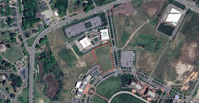
120 S Juniper St
Charlotte
Ncrckannapolis Downtown
Charlotte-Concord-Gastonia, NC-SC
P/O PARCEL B NC RESEARCH CAMPUS
5614-51-2906-0000
Cabarrus
Scientificpharmaceuticalmedicalresearchfacility
North Carolina
2025
27.57 AC
2025
Cabarrus County
041201
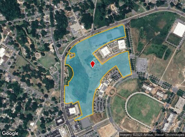
DEMOGRAPHICS near 120 S Juniper St
1 Mile
3 Mile
5 Mile
2024 Total Population
8,317
49,131
83,233
2029 Population
8,938
52,425
88,688
Pop Growth 2024-2029
+ 7.47%
+ 6.70%
+ 6.55%
Average Age
37
39
39
2024 Total Households
3,307
19,281
32,893
HH Growth 2024-2029
+ 7.59%
+ 6.87%
+ 6.72%
Median Household Inc
$61,135
$59,332
$63,449
Avg Household Size
2.50
2.50
2.50
2024 Avg HH Vehicles
2.00
2.00
2.00
Median Home Value
$249,139
$249,690
$269,258
Median Year Built
1957
1975
1984
Nearby Places
Map Layers
Map Styles
 Street
 Aerial
- Restaurants
- Banks
- Shops
- Fitness
- Groceries
PUBLIC TRANSPORTATION
COMMUTER RAIL
Kannapolis Station (Piedmont - North Carolina by Train (NC Train))
DRIVE
WALK
Distance
Kannapolis Station (Piedmont - North Carolina by Train (NC Train))
4 min
17 min
0.9 mi
AIRPORT
Concord-Padgett Regional
DRIVE
WALK
Distance
Concord-Padgett Regional
25 min
14.5 mi
Charlotte/Douglas International
DRIVE
WALK
Distance
Charlotte/Douglas International
51 min
34.8 mi
Freight Ports
Port of Wilmington
DRIVE
WALK
Distance
Port of Wilmington
266 min
203.8 mi
Nearby Properties
Address
Land Use
TOTAL SIZE
Lot Size
Zoning
Address
Land Use
TOTAL SIZE
Lot Size
Zoning
276,070 SF
CC
Address
Land Use
TOTAL SIZE
Lot Size
Zoning
114,382 SF
24.64 AC
R4
Address
Land Use
TOTAL SIZE
Lot Size
Zoning
176,676 SF
31.80 AC
R4
Address
Land Use
TOTAL SIZE
Lot Size
Zoning
128,064 SF
2.68 AC
CC
Address
Land Use
TOTAL SIZE
Lot Size
Zoning
121,156 SF
3.57 AC
CC
Address
Land Use
TOTAL SIZE
Lot Size
Zoning
106,804 SF
1.81 AC
CC
Address
Land Use
TOTAL SIZE
Lot Size
Zoning
83,152 SF
7.11 AC
CC
Address
Land Use
TOTAL SIZE
Lot Size
Zoning
176,075 SF
2.35 AC
CC
Address
Land Use
TOTAL SIZE
Lot Size
Zoning
114,250 SF
18.50 AC
RM-2
Address
Land Use
TOTAL SIZE
Lot Size
Zoning
5,308 SF
15.16 AC
RC
Address
Land Use
TOTAL SIZE
Lot Size
Zoning
85,422 SF
6.30 AC
R8
Address
Land Use
TOTAL SIZE
Lot Size
Zoning
67,862 SF
1.77 AC
CC
Address
Land Use
TOTAL SIZE
Lot Size
Zoning
12,010 SF
0.40 AC
CC
Address
Land Use
TOTAL SIZE
Lot Size
Zoning
66,194 SF
2.94 AC
CC
Address
Land Use
TOTAL SIZE
Lot Size
Zoning
101,014 SF
1.84 AC
CC
Address
Land Use
TOTAL SIZE
Lot Size
Zoning
56,923 SF
2 AC
CC
Address
Land Use
TOTAL SIZE
Lot Size
Zoning
68,257 SF
8.26 AC
R8
Address
Land Use
TOTAL SIZE
Lot Size
Zoning
64,554 SF
2.67 AC
CC
Address
Land Use
TOTAL SIZE
Lot Size
Zoning
26,069 SF
12.33 AC
C-1
Address
Land Use
TOTAL SIZE
Lot Size
Zoning
22,898 SF
10 AC
R18
Address
Land Use
TOTAL SIZE
Lot Size
Zoning
115,509 SF
4.90 AC
R8
Address
Land Use
TOTAL SIZE
Lot Size
Zoning
84,608 SF
23.75 AC
R8
Address
Land Use
TOTAL SIZE
Lot Size
Zoning
12,415 SF
25.46 AC
R8
Address
Land Use
TOTAL SIZE
Lot Size
Zoning
269,700 SF
76.24 AC
Address
Land Use
TOTAL SIZE
Lot Size
Zoning
13,689 SF
8.56 AC
R4
Address
Land Use
TOTAL SIZE
Lot Size
Zoning
78,771 SF
CC
Address
Land Use
TOTAL SIZE
Lot Size
Zoning
50,366 SF
1.64 AC
CC
Address
Land Use
TOTAL SIZE
Lot Size
Zoning
175,140 SF
1.12 AC
CC
Address
Land Use
TOTAL SIZE
Lot Size
Zoning
43,607 SF
14.75 AC
GC
Address
Land Use
TOTAL SIZE
Lot Size
Zoning
10,056 SF
10.11 AC
R8
The World's #1 Commercial Real Estate Marketplace
Connect with us
© 2025 CoStar Group
The information above has been obtained from sources believed reliable. While we do not doubt its accuracy we have not verified it and make no guarantee, warranty or representation about it. It is your responsibility to independently confirm its accuracy and completeness. Any projections, opinions, assumptions, or estimates used are for example only and do not represent the current or future performance of the property. The value of this transaction to you depends on tax and other factors which should be evaluated by your tax, financial, and legal advisors. You and your advisors should conduct a careful, independent investigation of the property to determine to your satisfaction the suitability of the property for your needs.