Property Record
421 N Main St, River Falls, WI 54022


Save to a Folder
{{folder.Name}}
{{folder.ListingIds.length}} Properties
{{folder.ListingIds.length}} Property
Create a New Folder
Property Detail
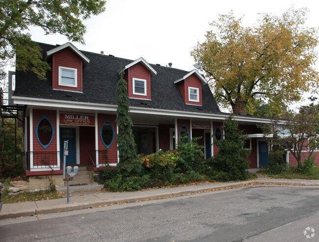
421 N Main St
Minneapolis-St. Paul-Bloomington, MN-WI
OL 48 & 49 AMENDED ASSESSORS PLAT EX .09 A FOR HWY PER V 294 P 695 (421 N MAIN)
276-01097-0100
Pierce
Commercialnec
Wisconsin
AE The base floodplain where base flood elevations are provided. AE Zones are now used on new format FIRMs instead of A1-A30 Zones.
48
2025
0.21 AC
2025
Pierce County
960400
Minneapolis/St Paul
NEARBY LISTINGS FOR SALE OR LEASE
DEMOGRAPHICS near 421 N Main St
1 mile
3 mile
5 mile
2025 Total Population
9,131
19,456
22,330
2030 Population
9,442
20,173
23,172
Pop Growth 2025-2030
+ 3.41%
+ 3.69%
+ 3.77%
Average Age
34
37
37
2025 Total Households
3,150
7,162
8,192
HH Growth 2025-2030
+ 4.60%
+ 4.36%
+ 4.35%
Median Household Inc
$74,367
$83,393
$89,240
Avg Household Size
2.30
2.40
2.40
2025 Avg HH Vehicles
2.00
2.00
2.00
Median Home Value
$316,821
$348,885
$364,782
Median Year Built
1980
1989
1990
Nearby Places
Map Layers
Map Styles
 Street
 Aerial
Layers
 Traffic
 Biking
Places
Listings with unknown addresses are not visible on the map
- Restaurants
- Banks
- Shops
- Fitness
- Groceries
PUBLIC TRANSPORTATION
AIRPORT
Minneapolis-St Paul International/Wold-Chamberlain
Drive
Walk
Distance
Minneapolis-St Paul International/Wold-Chamberlain
52 min
39.3 mi
Nearby Properties
Address
Land Use
TOTAL SIZE
Lot Size
Zoning
Address
Land Use
TOTAL SIZE
Lot Size
Zoning
5.75 AC
Address
Land Use
TOTAL SIZE
Lot Size
Zoning
3.22 AC
Address
Land Use
TOTAL SIZE
Lot Size
Zoning
5.51 AC
Address
Land Use
TOTAL SIZE
Lot Size
Zoning
7.59 AC
Address
Land Use
TOTAL SIZE
Lot Size
Zoning
Address
Land Use
TOTAL SIZE
Lot Size
Zoning
Address
Land Use
TOTAL SIZE
Lot Size
Zoning
Address
Land Use
TOTAL SIZE
Lot Size
Zoning
Address
Land Use
TOTAL SIZE
Lot Size
Zoning
3.28 AC
Address
Land Use
TOTAL SIZE
Lot Size
Zoning
Address
Land Use
TOTAL SIZE
Lot Size
Zoning
Address
Land Use
TOTAL SIZE
Lot Size
Zoning
5.63 AC
Address
Land Use
TOTAL SIZE
Lot Size
Zoning
Address
Land Use
TOTAL SIZE
Lot Size
Zoning
Address
Land Use
TOTAL SIZE
Lot Size
Zoning
1.38 AC
Address
Land Use
TOTAL SIZE
Lot Size
Zoning
1.82 AC
Address
Land Use
TOTAL SIZE
Lot Size
Zoning
2.61 AC
Address
Land Use
TOTAL SIZE
Lot Size
Zoning
5.78 AC
Address
Land Use
TOTAL SIZE
Lot Size
Zoning
Address
Land Use
TOTAL SIZE
Lot Size
Zoning
4.77 AC
Address
Land Use
TOTAL SIZE
Lot Size
Zoning
1.40 AC
Address
Land Use
TOTAL SIZE
Lot Size
Zoning
1.37 AC
Address
Land Use
TOTAL SIZE
Lot Size
Zoning
1.27 AC
Address
Land Use
TOTAL SIZE
Lot Size
Zoning
0.42 AC
Address
Land Use
TOTAL SIZE
Lot Size
Zoning
0.70 AC
Address
Land Use
TOTAL SIZE
Lot Size
Zoning
0.55 AC
Address
Land Use
TOTAL SIZE
Lot Size
Zoning
0.24 AC
Address
Land Use
TOTAL SIZE
Lot Size
Zoning
4.28 AC
Address
Land Use
TOTAL SIZE
Lot Size
Zoning
0.54 AC
Address
Land Use
TOTAL SIZE
Lot Size
Zoning
0.48 AC
The World's #1 Commercial Real Estate Marketplace
Connect with us
© 2026 CoStar Group
The information above has been obtained from sources believed reliable. While we do not doubt its accuracy we have not verified it and make no guarantee, warranty or representation about it. It is your responsibility to independently confirm its accuracy and completeness. Any projections, opinions, assumptions, or estimates used are for example only and do not represent the current or future performance of the property. The value of this transaction to you depends on tax and other factors which should be evaluated by your tax, financial, and legal advisors. You and your advisors should conduct a careful, independent investigation of the property to determine to your satisfaction the suitability of the property for your needs.