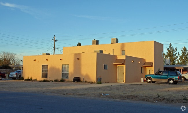
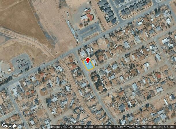
Property Record
421 Panahi Rd, El Paso, TX 79927

NEARBY LISTINGS FOR SALE OR LEASE
Property Detail
421 Panahi Rd
El Paso
Friedman Estates #1
El Paso, TX
21 FRIEDMAN ESTATES #2 LOT 28
F800-002-0210-0280
El Paso
Quadruplex
Texas
2024
28
2025
0.22 AC
010410
Outer Socorro
2,862 SF
DEMOGRAPHICS near 421 Panahi Rd
1 Mile
3 Mile
5 Mile
2024 Total Population
8,626
36,071
70,635
2029 Population
8,935
36,291
71,368
Pop Growth 2024-2029
+ 3.58%
+ 0.61%
+ 1.04%
Average Age
35
36
36
2024 Total Households
2,555
10,790
21,031
HH Growth 2024-2029
+ 3.48%
+ 0.56%
+ 1.01%
Median Household Inc
$43,346
$40,514
$42,638
Avg Household Size
3.30
3.30
3.30
2024 Avg HH Vehicles
2.00
2.00
2.00
Median Home Value
$134,403
$118,639
$114,675
Median Year Built
1997
1995
1995
Nearby Places
Map Layers
Map Styles
 Street
 Aerial
- Restaurants
- Banks
- Shops
- Fitness
- Groceries
PUBLIC TRANSPORTATION
AIRPORT
El Paso International
DRIVE
WALK
Distance
El Paso International
36 min
19.2 mi
Freight Ports
Port of Corpus Christi
DRIVE
WALK
Distance
Port of Corpus Christi
667 min
679.1 mi
Nearby Properties
Address
Land Use
TOTAL SIZE
Lot Size
Zoning
Address
Land Use
TOTAL SIZE
Lot Size
Zoning
393,206 SF
66.48 AC
SU
Address
Land Use
TOTAL SIZE
Lot Size
Zoning
953,000 SF
45.97 AC
M2
Address
Land Use
TOTAL SIZE
Lot Size
Zoning
392,214 SF
29.67 AC
Address
Land Use
TOTAL SIZE
Lot Size
Zoning
618,222 SF
25.18 AC
M2
Address
Land Use
TOTAL SIZE
Lot Size
Zoning
127,840 SF
17.66 AC
Address
Land Use
TOTAL SIZE
Lot Size
Zoning
450,900 SF
20.46 AC
M2
Address
Land Use
TOTAL SIZE
Lot Size
Zoning
131,564 SF
18.62 AC
Address
Land Use
TOTAL SIZE
Lot Size
Zoning
475,547 SF
26.82 AC
Address
Land Use
TOTAL SIZE
Lot Size
Zoning
84,207 SF
20 AC
Address
Land Use
TOTAL SIZE
Lot Size
Zoning
138,279 SF
17.42 AC
Address
Land Use
TOTAL SIZE
Lot Size
Zoning
85,524 SF
12 AC
Address
Land Use
TOTAL SIZE
Lot Size
Zoning
242,991 SF
8.81 AC
M2
Address
Land Use
TOTAL SIZE
Lot Size
Zoning
77,284 SF
12.75 AC
Address
Land Use
TOTAL SIZE
Lot Size
Zoning
45,091 SF
5.25 AC
Address
Land Use
TOTAL SIZE
Lot Size
Zoning
35,577 SF
4.75 AC
C3
Address
Land Use
TOTAL SIZE
Lot Size
Zoning
202.01 AC
Address
Land Use
TOTAL SIZE
Lot Size
Zoning
71,400 SF
4.27 AC
Address
Land Use
TOTAL SIZE
Lot Size
Zoning
72,444 SF
3.77 AC
Address
Land Use
TOTAL SIZE
Lot Size
Zoning
22,600 SF
3.08 AC
Address
Land Use
TOTAL SIZE
Lot Size
Zoning
168,471 SF
9.13 AC
Address
Land Use
TOTAL SIZE
Lot Size
Zoning
88,645 SF
4.87 AC
Address
Land Use
TOTAL SIZE
Lot Size
Zoning
77,290 SF
4.05 AC
C2
Address
Land Use
TOTAL SIZE
Lot Size
Zoning
19,805 SF
2.66 AC
Address
Land Use
TOTAL SIZE
Lot Size
Zoning
14,980 SF
1.94 AC
C1
Address
Land Use
TOTAL SIZE
Lot Size
Zoning
14,790 SF
1.99 AC
C2
Address
Land Use
TOTAL SIZE
Lot Size
Zoning
45,471 SF
4.01 AC
C2
Address
Land Use
TOTAL SIZE
Lot Size
Zoning
23,400 SF
3.52 AC
Address
Land Use
TOTAL SIZE
Lot Size
Zoning
25,000 SF
1.85 AC
C2
Address
Land Use
TOTAL SIZE
Lot Size
Zoning
54,675 SF
3.24 AC
Address
Land Use
TOTAL SIZE
Lot Size
Zoning
8,496 SF
2.70 AC
C1
The World's #1 Commercial Real Estate Marketplace
Connect with us
© 2025 CoStar Group
The information above has been obtained from sources believed reliable. While we do not doubt its accuracy we have not verified it and make no guarantee, warranty or representation about it. It is your responsibility to independently confirm its accuracy and completeness. Any projections, opinions, assumptions, or estimates used are for example only and do not represent the current or future performance of the property. The value of this transaction to you depends on tax and other factors which should be evaluated by your tax, financial, and legal advisors. You and your advisors should conduct a careful, independent investigation of the property to determine to your satisfaction the suitability of the property for your needs.