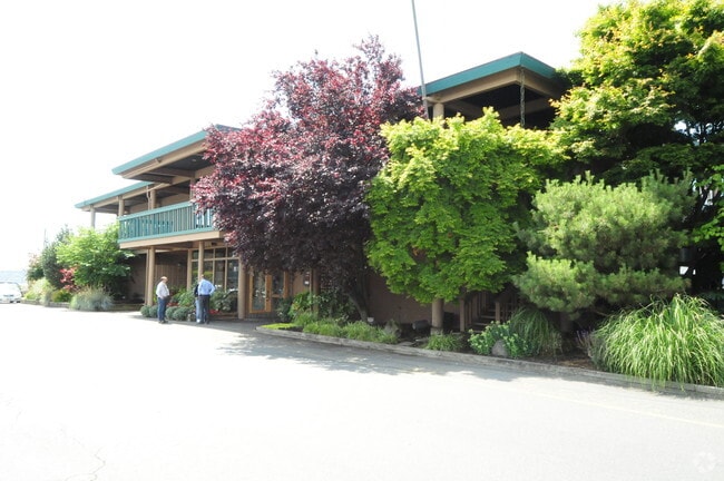
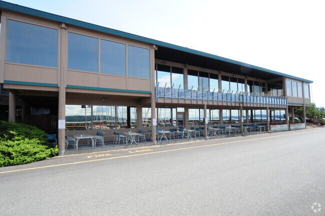
Property Record
421 S 227Th St, Des Moines, WA 98198


NEARBY LISTINGS FOR SALE OR LEASE
Property Detail
421 S 227Th St
Seattle-Tacoma-Bellevue, WA
Des Moines City Of
200660-1240
CITY OF DES MOINES PORTIONS VACATED BLKS 83 & 84 & OF VACATED STREETS & ALLEYS ADJOINING AND PORTION OF SECOND CLASS TIDELANDS TO LINE OF EXTREME LOW TIDE LYING ADJACENT TO GOVT LOT 2 IN NW QTR STR 17-22-04 DAF: BEGINNING AT INTERSECTION OF E LINE SA
Restaurantbuilding
King
AE
Washington
53033C0964G
s
2025
1.60 AC
2024
SeaTac/Burien
029001
Seattle/Puget Sound
14,408 SF
DEMOGRAPHICS near 421 S 227Th St
1 Mile
3 Mile
5 Mile
2024 Total Population
8,079
62,779
163,639
2029 Population
8,072
63,018
164,833
Pop Growth 2024-2029
(0.09%)
+ 0.38%
+ 0.73%
Average Age
45
40
40
2024 Total Households
3,436
22,566
60,474
HH Growth 2024-2029
(0.26%)
+ 0.17%
+ 0.61%
Median Household Inc
$80,517
$80,372
$78,193
Avg Household Size
2.20
2.60
2.60
2024 Avg HH Vehicles
2.00
2.00
2.00
Median Home Value
$577,713
$491,104
$497,560
Median Year Built
1975
1976
1977
Nearby Places
Map Layers
Map Styles
 Street
 Aerial
- Restaurants
- Banks
- Shops
- Fitness
- Groceries
PUBLIC TRANSPORTATION
COMMUTER RAIL
Kent Station (Sounder South Line - Central Puget Sound Regional Transit Authority Rail (Link Light Rail/Sounder))
DRIVE
WALK
Distance
Kent Station (Sounder South Line - Central Puget Sound Regional Transit Authority Rail (Link Light Rail/Sounder))
12 min
6.2 mi
Kent Station (Seattle - Tacoma/Lakewood - Sound Transit)
DRIVE
WALK
Distance
Kent Station (Seattle - Tacoma/Lakewood - Sound Transit)
12 min
6.2 mi
AIRPORT
Seattle-Tacoma International
DRIVE
WALK
Distance
Seattle-Tacoma International
15 min
6.0 mi
Freight Ports
Port of Tacoma
DRIVE
WALK
Distance
Port of Tacoma
26 min
17.9 mi
Nearby Properties
Address
Land Use
TOTAL SIZE
Lot Size
Zoning
Address
Land Use
TOTAL SIZE
Lot Size
Zoning
342,484 SF
58.76 AC
I2
Address
Land Use
TOTAL SIZE
Lot Size
Zoning
358,292 SF
18.98 AC
I-C
Address
Land Use
TOTAL SIZE
Lot Size
Zoning
435,187 SF
31.48 AC
I2
Address
Land Use
TOTAL SIZE
Lot Size
Zoning
297,018 SF
11.48 AC
MCR
Address
Land Use
TOTAL SIZE
Lot Size
Zoning
436,880 SF
25.62 AC
AVC
Address
Land Use
TOTAL SIZE
Lot Size
Zoning
245,078 SF
6.32 AC
MCR
Address
Land Use
TOTAL SIZE
Lot Size
Zoning
348,445 SF
14.93 AC
B-P
Address
Land Use
TOTAL SIZE
Lot Size
Zoning
156,248 SF
15.64 AC
R-SE
Address
Land Use
TOTAL SIZE
Lot Size
Zoning
299,975 SF
11.26 AC
PR-C
Address
Land Use
TOTAL SIZE
Lot Size
Zoning
293,349 SF
3.54 AC
B-P
Address
Land Use
TOTAL SIZE
Lot Size
Zoning
195,216 SF
8.85 AC
MR-M
Address
Land Use
TOTAL SIZE
Lot Size
Zoning
245,520 SF
9.98 AC
B-P
Address
Land Use
TOTAL SIZE
Lot Size
Zoning
248,499 SF
11.50 AC
PR-C
Address
Land Use
TOTAL SIZE
Lot Size
Zoning
192,960 SF
18.02 AC
MR-M
Address
Land Use
TOTAL SIZE
Lot Size
Zoning
191,592 SF
14.13 AC
MR-M
Address
Land Use
TOTAL SIZE
Lot Size
Zoning
215,040 SF
12.19 AC
MR-M
Address
Land Use
TOTAL SIZE
Lot Size
Zoning
271,708 SF
11.51 AC
I2
Address
Land Use
TOTAL SIZE
Lot Size
Zoning
19,008 SF
12.79 AC
RBX
Address
Land Use
TOTAL SIZE
Lot Size
Zoning
130,340 SF
14.98 AC
UM-3600
Address
Land Use
TOTAL SIZE
Lot Size
Zoning
166,656 SF
18.24 AC
UM-3600
Address
Land Use
TOTAL SIZE
Lot Size
Zoning
376,472 SF
0.28 AC
CB-C
Address
Land Use
TOTAL SIZE
Lot Size
Zoning
190,219 SF
21.40 AC
RS-7200
Address
Land Use
TOTAL SIZE
Lot Size
Zoning
116,365 SF
2.64 AC
UH-UCR
Address
Land Use
TOTAL SIZE
Lot Size
Zoning
159,360 SF
8.88 AC
I-C
Address
Land Use
TOTAL SIZE
Lot Size
Zoning
368,054 SF
9.33 AC
PR-C
Address
Land Use
TOTAL SIZE
Lot Size
Zoning
266,605 SF
1.58 AC
PR-C
Address
Land Use
TOTAL SIZE
Lot Size
Zoning
158,110 SF
8.91 AC
UM-2400
Address
Land Use
TOTAL SIZE
Lot Size
Zoning
138,900 SF
5.22 AC
MR-M
Address
Land Use
TOTAL SIZE
Lot Size
Zoning
147,056 SF
8.46 AC
UH-900
The World's #1 Commercial Real Estate Marketplace
Connect with us
© 2026 CoStar Group
The information above has been obtained from sources believed reliable. While we do not doubt its accuracy we have not verified it and make no guarantee, warranty or representation about it. It is your responsibility to independently confirm its accuracy and completeness. Any projections, opinions, assumptions, or estimates used are for example only and do not represent the current or future performance of the property. The value of this transaction to you depends on tax and other factors which should be evaluated by your tax, financial, and legal advisors. You and your advisors should conduct a careful, independent investigation of the property to determine to your satisfaction the suitability of the property for your needs.