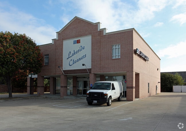
Property Record
4210 Dalrock Rd, Rowlett, TX 75088

Property Detail
4210 Dalrock Rd
Dallas-Fort Worth-Arlington, TX
KYONG SONG ADDITION, BLOCK 1, LOT 1R, ACRES .527, (REPLAT 2007)
50189
Rockwall
Commercialnec
Texas
B and X Area of moderate flood hazard, usually the area between the limits of the 100-year and 500-year floods.
1r
2024
0.53 AC
2025
Sachse/Rowlett
040301
Dallas/Ft Worth
3,000 SF
NEARBY LISTINGS FOR SALE OR LEASE
DEMOGRAPHICS near 4210 Dalrock Rd
1 mile
3 mile
5 mile
2025 Total Population
11,361
49,198
143,928
2030 Population
12,531
53,433
158,616
Pop Growth 2025-2030
+ 10.30%
+ 8.61%
+ 10.21%
Average Age
40
40
40
2025 Total Households
3,832
17,869
50,936
HH Growth 2025-2030
+ 10.26%
+ 9.14%
+ 10.39%
Median Household Inc
$95,564
$102,512
$101,378
Avg Household Size
2.90
2.70
2.80
2025 Avg HH Vehicles
2.00
2.00
2.00
Median Home Value
$333,595
$369,278
$378,188
Median Year Built
1993
1995
1997
Nearby Places
Map Layers
Map Styles
 Street
 Aerial
Transit
 Traffic
 Biking
Places
Listings with unknown addresses are not visible on the map
- Restaurants
- Banks
- Shops
- Fitness
- Groceries
PUBLIC TRANSPORTATION
AIRPORT
Dallas Love Field
Drive
Walk
Distance
Dallas Love Field
38 min
24.6 mi
Dallas-Fort Worth International
Drive
Walk
Distance
Dallas-Fort Worth International
51 min
41.4 mi
SALE & LEASE HISTORY
LISTING DATE
SALE/LEASE

May 15, 2020
For Sale
Apr 06, 2019
For Sale
Nearby Properties
Address
Land Use
TOTAL SIZE
Lot Size
Zoning
Address
Land Use
TOTAL SIZE
Lot Size
Zoning
559,567 SF
10.85 AC
Z80
Address
Land Use
TOTAL SIZE
Lot Size
Zoning
252,909 SF
11.73 AC
Address
Land Use
TOTAL SIZE
Lot Size
Zoning
283,096 SF
10.18 AC
Z80
Address
Land Use
TOTAL SIZE
Lot Size
Zoning
454,141 SF
4.86 AC
Address
Land Use
TOTAL SIZE
Lot Size
Zoning
260,782 SF
16.30 AC
Z77
Address
Land Use
TOTAL SIZE
Lot Size
Zoning
228,458 SF
5.56 AC
Z236
Address
Land Use
TOTAL SIZE
Lot Size
Zoning
427,231 SF
9.96 AC
Z38
Address
Land Use
TOTAL SIZE
Lot Size
Zoning
313,217 SF
3.61 AC
Z205
Address
Land Use
TOTAL SIZE
Lot Size
Zoning
282,628 SF
4.03 AC
Address
Land Use
TOTAL SIZE
Lot Size
Zoning
710,600 SF
3.91 AC
Z80
Address
Land Use
TOTAL SIZE
Lot Size
Zoning
178,125 SF
10.50 AC
Z77
Address
Land Use
TOTAL SIZE
Lot Size
Zoning
495,735 SF
2.92 AC
Z80
Address
Land Use
TOTAL SIZE
Lot Size
Zoning
138,183 SF
4.76 AC
Z80
Address
Land Use
TOTAL SIZE
Lot Size
Zoning
144,725 SF
12.89 AC
Address
Land Use
TOTAL SIZE
Lot Size
Zoning
227,296 SF
2.14 AC
Address
Land Use
TOTAL SIZE
Lot Size
Zoning
196,981 SF
8.92 AC
Address
Land Use
TOTAL SIZE
Lot Size
Zoning
43,600 SF
62.86 AC
Z306
Address
Land Use
TOTAL SIZE
Lot Size
Zoning
85,912 SF
5.93 AC
Address
Land Use
TOTAL SIZE
Lot Size
Zoning
420,500 SF
33.25 AC
Address
Land Use
TOTAL SIZE
Lot Size
Zoning
244,338 SF
4.44 AC
Address
Land Use
TOTAL SIZE
Lot Size
Zoning
271,051 SF
10.28 AC
Z01
Address
Land Use
TOTAL SIZE
Lot Size
Zoning
108,429 SF
2.06 AC
Address
Land Use
TOTAL SIZE
Lot Size
Zoning
99,800 SF
10.10 AC
C
Address
Land Use
TOTAL SIZE
Lot Size
Zoning
92,413 SF
4.98 AC
Z85
Address
Land Use
TOTAL SIZE
Lot Size
Zoning
151,893 SF
5.40 AC
Z308
Address
Land Use
TOTAL SIZE
Lot Size
Zoning
82,847 SF
4.87 AC
Z236
Address
Land Use
TOTAL SIZE
Lot Size
Zoning
78,017 SF
1.75 AC
Z236
Address
Land Use
TOTAL SIZE
Lot Size
Zoning
80,042 SF
6.42 AC
Address
Land Use
TOTAL SIZE
Lot Size
Zoning
140,000 SF
12.76 AC
Address
Land Use
TOTAL SIZE
Lot Size
Zoning
57,303 SF
7.68 AC
The World's #1 Commercial Real Estate Marketplace
Connect with us
© 2026 CoStar Group
The information above has been obtained from sources believed reliable. While we do not doubt its accuracy we have not verified it and make no guarantee, warranty or representation about it. It is your responsibility to independently confirm its accuracy and completeness. Any projections, opinions, assumptions, or estimates used are for example only and do not represent the current or future performance of the property. The value of this transaction to you depends on tax and other factors which should be evaluated by your tax, financial, and legal advisors. You and your advisors should conduct a careful, independent investigation of the property to determine to your satisfaction the suitability of the property for your needs.